
Kongens Nytorv station
Encyclopedia
Kongens Nytorv Station is a rapid transit station on the Copenhagen Metro
, Copenhagen
, Denmark
. It is located under Kongens Nytorv
plaza, in fare zone 1.
and the M2
, serve Kongens Nytorv. Both operate westbound towards Vanløse
and eastbound towards Vestamager
on the M1 and Lufthavnen
on the M2. When the City Circle Line is completed in 2018, Kongens Nytorv will act as a connection between the existing metro lines and the new M3 and M4.
Copenhagen Metro
Copenhagen Metro is a rapid transit system serving Copenhagen, Frederiksberg and Tårnby in Denmark. The system opened between 2002 and 2007, and has two lines, M1 and M2. The driverless light metro supplements the larger S-train rapid transit system, and is integrated with DSB local trains and...
, Copenhagen
Copenhagen
Copenhagen is the capital and largest city of Denmark, with an urban population of 1,199,224 and a metropolitan population of 1,930,260 . With the completion of the transnational Øresund Bridge in 2000, Copenhagen has become the centre of the increasingly integrating Øresund Region...
, Denmark
Denmark
Denmark is a Scandinavian country in Northern Europe. The countries of Denmark and Greenland, as well as the Faroe Islands, constitute the Kingdom of Denmark . It is the southernmost of the Nordic countries, southwest of Sweden and south of Norway, and bordered to the south by Germany. Denmark...
. It is located under Kongens Nytorv
Kongens Nytorv
Kongens Nytorv is a public square in Copenhagen, Denmark, centrally located at the end of the pedestrian street Strøget. The finest and largest square of the city, it was laid out by Christian V in 1670 in connection with a major extension of the fortified city, and has an equestrian statue of...
plaza, in fare zone 1.
Station layout
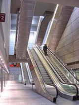
Kongens Nytorv is built and designed in the same style as other underground stations on the Copenhangen Metro. There are two main levels below ground level; the first is a few steps down from the street. At this level, passengers take an escalator down to a mezzanine switchback that makes them turn around and go down another escalator to reach platform level. There is also a lift that transports passengers to the platform. There are two entrances to the station as well: the southwestern corner of the intersection of Kongens Nytorv, Lille Kongensgade, Holmens Kanal, and Store Kongensgade and the other inside the Magasin du Nord department store.Service
Currently, both Copenhagen Metro lines, the M1M1 (Copenhagen)
M1 of the Copenhagen Metro, colored green on the map, runs from Vanløse to Vestamager. It connects the Ørestad neighborhood of Copenhagen, Denmark, to the city center. The line is elevated while traveling through Øresund, while it runs in a tunnel below the city center...
and the M2
M2 (Copenhagen)
M2 is a line of the Copenhagen Metro, colored yellow on the map. It runs from Vanløse to Lufthavnen through the center of Copenhagen, sharing track with the M1 from Vanløse to Christianshavn. The line was built along with M1 as part of the redevelopment of Ørestad. The principle of the line was...
, serve Kongens Nytorv. Both operate westbound towards Vanløse
Vanløse station
Vanløse Station is an S-train and Copenhagen Metro station in the Vanløse district of Copenhagen, Denmark. The metro station at street level is the eastern terminus of lines M1 and M2. S-trains on the Frederikssund radial stop at an upper level to the south of the Metro station...
and eastbound towards Vestamager
Vestamager station
Vestamager Station is a rapid transit station on the Copenhagen Metro, Denmark. It is the terminus of the M1 line. Opened in 2002, it is located in fare zone 3, in Ørestad Syd, also called the Vestamager District. The station is close to Kalvebod Fælled and next to the metro's Control and...
on the M1 and Lufthavnen
Lufthavnen Station
Lufthavnen Station is a rapid transit station of the Copenhagen Metro, located at Copenhagen Airport on the island of Amager. The station is the terminus of the M2 line and is located in fare zone 4....
on the M2. When the City Circle Line is completed in 2018, Kongens Nytorv will act as a connection between the existing metro lines and the new M3 and M4.