

Kohala, Hawaii
Encyclopedia

Hawaii (island)
The Island of Hawaii, also called the Big Island or Hawaii Island , is a volcanic island in the North Pacific Ocean...
in the Hawaiian Archipelago
Hawaiian Islands
The Hawaiian Islands are an archipelago of eight major islands, several atolls, numerous smaller islets, and undersea seamounts in the North Pacific Ocean, extending some 1,500 miles from the island of Hawaii in the south to northernmost Kure Atoll...
. In ancient Hawaii
Ancient Hawaii
Ancient Hawaii refers to the period of Hawaiian human history preceding the unification of the Kingdom of Hawaii by Kamehameha the Great in 1810. After being first settled by Polynesian long-distance navigators sometime between AD 300–800, a unique culture developed. Diversified agroforestry and...
it was often ruled by an independent High Chief called the Alii Nui
Alii Aimoku of Hawaii
The following is a list of alii aimoku of Hawaii. "Alii aimoku" refers to the ruler of the island. alii refers to the ruling class of ancient Hawaii...
. In modern times it is divided into two districts of Hawaii County
Hawaii County, Hawaii
Hawaii County is a county located in the U.S. state of Hawaii in the Hawaiian Islands. It is coterminous with the Island of Hawaii, often called the "Big Island" to distinguish it from the state as a whole. As of the 2010 Census the population was 185,079. The county seat is Hilo. There are no...
: North Kohala and South Kohala. Locals commonly use the name singularly when referring to the area surrounding the towns of Hāwī and Kapaau. The dry western shore is commonly known as the Kohala Coast, which has golf courses and seaside resorts.
Description
The area was named after the dominating geological feature Kohala MountainKohala (mountain)
Kohala is the oldest of five volcanoes that make up the island of Hawaii. Kohala is an estimated one million years old—so old that it experienced, and recorded, a reversal of magnetic field 780,000 years ago. It is believed to have breached sea level more than 500,000 years ago and to...
, the oldest of Hawaii Island's five major volcanic mountains. The current districts cover the north and western sides of the mountain, 20°7′55"N 155°47′38"W.
It was one of the five ancient divisions of the island called moku.
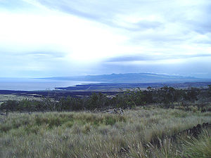
The natural habitats in Kohala range across a wide rainfall gradient in a very short distance - from less than 5 inches (127 mm) a year on the coast near Kawaihae
Kawaihae
Kawaihae is an unincorporated community on the west side of the island of Hawaii in the U.S. state of Hawaii, north of Kailua-Kona. Its harbor includes a fuel depot, shipping terminal and military landing site. Outside of the man-made breakwall of the harbor is a popular surf spot and the Pua...
to more than 150 inches (3,810 mm) year near the summit of Kohala Mountain, a distance of just 11 miles (17.7 km). Near the coast are remnants of dry forests
Hawaiian tropical dry forests
The Hawaiian tropical dry forests are a tropical dry broadleaf forest ecoregion in the Hawaiian Islands. They cover an area of on the leeward side of the main islands and the summits of Niihau and Kahoolawe. These forests are either seasonal or sclerophyllous. Annual rainfall is less than and...
, and near the summit is a cloud forest
Cloud forest
A cloud forest, also called a fog forest, is a generally tropical or subtropical evergreen montane moist forest characterized by a persistent, frequent or seasonal low-level cloud cover, usually at the canopy level. Cloud forests often exhibit an abundance of mosses covering the ground and...
, a type of rainforest that obtains some of its moisture from "cloud drip" in addition to precipitation.
This precipitation allowed the northeast coast to be developed into sugarcane plantations
Sugar plantations in Hawaii
Sugarcane was introduced to Hawaii by its first inhabitants in approximately 600 AD and was observed by Captain Cook upon arrival in the islands in 1778. Sugar quickly turned into a big business and generated rapid population growth in the islands with 337,000 people immigrating over the span of a...
, including one founded by Rev. Elias Bond
Elias Bond
The Bond District is a collection of historic buildings located in the district of North Kohala on the island of Hawaii.The district has three sections: the homestead of missionaries Ellen and Reverend Elias Bond , Kalahikiola Church, and the Kohala Seminary.-Ellen and Elias Bond:Elias Bond was...
used to fund his church and girls' seminary.
Kamehameha I
Kamehameha I , also known as Kamehameha the Great, conquered the Hawaiian Islands and formally established the Kingdom of Hawaii in 1810. By developing alliances with the major Pacific colonial powers, Kamehameha preserved Hawaii's independence under his rule...
, the first King of the unified Hawaiian Islands, was born in North Kohala west of Hāwī, at an ancient site called the Mookini Heiau, preserved within Kohala Historical Sites State Monument. The original Kamehameha Statue
Kamehameha Statue
Several Kamehameha Statues honor the monarch who founded the Kingdom of Hawaii.-Gould's work:One stands prominently in front of Aliiolani Hale in Honolulu, Hawaii. The statue had its origins in 1878 when Walter M. Gibson, a member of the Hawaiian government at the time, wanted to commemorate the...
stands in front of the community center in Kapaau, and duplicates are found at Aliiolani Hale
Aliiolani Hale
Aliiōlani Hale is a building located in downtown Honolulu, Hawaii, currently used as the home of the Hawaii State Supreme Court. It is the former seat of government of the Kingdom of Hawaii and the Republic of Hawaii....
in Honolulu, and in the US Capitol in Washington, D.C.
Other parks include Hapuna Beach State Recreation Area
Hapuna Beach State Recreation Area
Hāpuna Beach State Recreation Area is a large park and sandy beach on the Big Island of Hawaii. The Hapuna Beach Prince Hotel is also located adjacent to the beach. Hāpuna is popular with residents and visitors....
, Samuel Spencer Beach, Puukoholā Heiau National Historic Site, Lapakahi State Historical Park
Lapakahi State Historical Park
Lapakahi State Historical Park is a large area of ruins from an Ancient Hawaiian fishing village in the North Kohala District on the Big Island of Hawaii.Off shore is the Lapakahi Marine Life Conservation District....
. and kēōkea Beach County Park.
The end of Akoni Pule Highway
Akoni Pule Highway
The Akoni Pule Highway, Hawaii State Highway Route 270, is the main road along the North Kohala Coast on the Island of Hawaii from Kawaihae to Upolu Point and then on to Pololū Valley Lookout.* Total miles = 27.0 -History:...
(Hawaii state route 270) provides access to Pololū Valley
Pololu Valley
Pololū is the Northernmost of a series of erosional valleys forming the east coast of Kohala Mountain on the Island of Hawaii. The word Pololū means long spear in the Hawaiian language.- Features :...
. The Hawaii Belt Road connects in the southern end of the Akoni Pule Highway to Kona
Kona District, Hawaii
Kona is the name of a moku or district on the Big Island of Hawaii in the State of Hawaii. In the current system of administration of Hawaii County, the moku of Kona is divided into North Kona District and South Kona District . The term "Kona" is sometimes used to refer to its largest town,...
in the south and Hāmākua
Hamakua
thumb|right|280px|Districts of [[Hawaii |Hawaii island]]: from northernmost, clockwise; [[Kohala, Hawaii|Kohala]], Hāmākua , [[Hilo, Hawaii|Hilo]], [[Puna, Hawaii|Puna]], [[Kau, Hawaii|Kaū]], [[Kona District, Hawaii|Kona]]...
to the east.
Kohala has two small airports. Upolu Airport
Upolu Airport
Upolu Airport is a regional airport of the State of Hawai'i in Hawai'i County. Located on the northern tip of the Big Island, Upolu Airport is northwest of the unincorporated town of Hawi.- Facilities and aircraft :...
is on Upolu Point
Upolu Point
Upolu Point is the most northern point on the island of Hawaii in the Hawaiian Islands. It is an extruding landform created by cooled lava from an old eruption from Kohala volcano. The main town on the extrusion is Hawi, Hawaii about 2 miles inland...
at the northern tip of the island.
Waimea-Kohala Airport
Waimea-Kohala Airport
Waimea-Kohala Airport is an airport located one nautical mile southwest of Kamuela , an unincorporated town in Hawai‘i County, Hawai‘i, United States....
is south of the town of Waimea, Hawaii County, Hawaii.
Neither has commercial flights.
Census-designated places of North and South Kohala
- Halaula
- Hāwī
- Kapaau
- Puako
- Waikoloa Village
- Waimea