
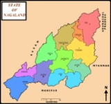
Kiphire
Encyclopedia

Kiphire district
Kiphire is the newly formed ninth district of Nagaland which was carved out of Tuensang District. As of 2011 it is the second least populous district of Nagaland , after Longleng.-Geography:...
, carved out of Tuensang district, in Nagaland
Nagaland
Nagaland is a state in the far north-eastern part of India. It borders the state of Assam to the west, Arunachal Pradesh and part of Assam to the north, Burma to the east and Manipur to the south. The state capital is Kohima, and the largest city is Dimapur...
, India
India
India , officially the Republic of India , is a country in South Asia. It is the seventh-largest country by geographical area, the second-most populous country with over 1.2 billion people, and the most populous democracy in the world...
. Kiphire is about 254 km from Kohima
Kohima
Kohima is the hilly capital of India's north eastern border state of Nagaland which shares its borders with Burma. It lies in Kohima District and is also one of the three Nagaland towns with Municipal council status along with Dimapur and Mokokchung....
, the capital of Nagaland.
It is the place where the Naga tribes of Sangtam (Eastern), Yimchunger and Sema tribes meet. The town is the nearest district headquarters to Mt. Saramati (3841 m or 12,602 ft), Nagaland's highest peak.