

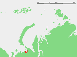
Khaypudyr Bay
Encyclopedia
Headlands and bays
Headlands and bays are two related features of the coastal environment.- Geology and geography :Headlands and bays are often found on the same coastline. A bay is surrounded by land on three sides, whereas a headland is surrounded by water on three sides. Headlands are characterized by high,...
in Russia
Russia
Russia or , officially known as both Russia and the Russian Federation , is a country in northern Eurasia. It is a federal semi-presidential republic, comprising 83 federal subjects...
, located in the Pechora Sea
Pechora Sea
Pechora Sea , is a sea at the northwest of Russia, the southeastern part of the Barents Sea. The western border of the sea is off Kolguyev Island, while the eastern border is the western coasts of Vaygach Island and the Yugorsky Peninsula, and the northern border the southern end of Novaya...
(Southeastern Barents Sea) between the coastline of the Yugorsky Peninsula
Yugorsky Peninsula
The Yugorsky Peninsula is a large peninsula in Nenets Autonomous Okrug, Russia. It is limited by the Khaypudyr Bay in the Pechora Sea to the west and by the Baydaratsk Bay in the Kara Sea to the north and east.Latitude : 68° 40' Longitude : 62° 15'...
and the lowlands and marshy areas in the mainland south of Dolgiy Island
Dolgiy Island
Dolgy Island is an island in the Pechora Sea, east of the Khaypudyr Bay. Long and narrow, this island is in length, with an average width of...
. Its latitude is 68° 30' N and the longitude 59° 30' E.
The Khaypudyr Bay has a smaller bay within a larger one. The length of the wider gulf is approximately of 80 km, mouth width - 60 km. The smaller inner bay is often considered to be the Khaypudyr Bay proper. Its shape is rounder and it is located on the southwest shore of the larger one. Its length is 33 km and the width of its northward-facing mouth is 15 km. Its waters are very shallow, with an average depth between 1 and 2 m only.
The surface water temperature is 7C during summertime. The gulf freezes up during winter. The rivers Naulyakha, Talotayakha, Moreyu and Korotaikha flow into the Khaypudyr Bay.
This bay and its surroundings belong to the Nenets Autonomous Okrug
Nenets Autonomous Okrug
Nenets Autonomous Okrug is a federal subject of Russia .It has an area of 176,700 km2 and population of 42,628 as of the preliminary results of the 2010 Census , 21,296 of whom live in Naryan-Mar, the administrative center.-Geography and ecology:The arctic ecology of this...
administrative region of the Russian Federation, which is an autonomous okrug of Arkhangelsk Oblast
Arkhangelsk Oblast
Arkhangelsk Oblast is a federal subject of Russia . It includes the Arctic archipelagos of Franz Josef Land and Novaya Zemlya, as well as the Solovetsky Islands in the White Sea....
.