
Kentucky Dam
Encyclopedia
Kentucky Dam is a hydroelectric dam on the Tennessee River
on the county line between Livingston County
and Marshall County
in the U.S. state
of Kentucky
. The dam is the lowermost of nine dams on the river owned and operated by the Tennessee Valley Authority
, which built the dam in the late 1930s and early 1940s to improve navigation on the lower part of the river and reduce flooding on the lower Ohio
and Mississippi
rivers. The dam impounds the Kentucky Lake
of 160000 acres (64,749.8 ha), which is the largest of TVA's reservoirs and the largest artificial lake by area in the Eastern United States. A canal connects Kentucky Lake to nearby Lake Barkley
, created by Barkley Dam
on the Cumberland River
. The lakes run parallel for more than 50 miles (80 km), with the Land Between the Lakes National Recreation Area located between them.
. After absorbing the Tennessee, the Ohio flows for another 46 miles (74 km) before emptying into the Mississippi River at Cairo, Illinois
. The dam is approximately 20 miles (32.2 km) north of the Kentucky-Tennessee
border and 10 miles (16.1 km) southeast of the Kentucky-Illinois
border. The city of Grand Rivers
is located northeast of the dam, and Gilbertsville
and Calvert City
are immediately downstream. Kentucky Lake stretches southward for 184 miles (296.1 km) across Kentucky and most of the length of Tennessee to the base of Pickwick Landing Dam
, near the Tennessee-Alabama
line, and includes parts of Livingston, Marshall, Lyon
, Calloway
, and Trigg
counties in Kentucky and parts of Humphreys
, Benton, Decatur, Stewart, Carroll
, Wayne
, Henderson, Henry, Perry, Houston, and Hardin
counties in Tennessee.
Barkley Dam, which is operated by the U.S. Army Corps of Engineers, is located along the Cumberland River
just opposite Lake City a few miles east of Kentucky Dam. The canal connecting Kentucky and Barkley Lakes joins Kentucky Lake approximately 3 miles (4.8 km) upstream from Kentucky Dam.
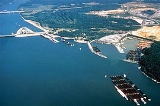
Kentucky Dam is serviced by a 600 by navigation lock
, soon to be supplemented by a larger 1200 by lock which will be better able to accommodate the long barge tows which navigate the river. A large industrial complex of chemical plants developed below the dam near Calvert City, Kentucky, due to the convenient barge transportation and inexpensive TVA electricity. The locks' lift raises and lowers vessels up to 75 feet (22.9 m) between Kentucky Lake and the lower part of the river.
 Throughout the 19th century, Congress passed a series of initiatives to improve navigation on the Tennessee River between the river's mouth and Florence, Alabama
. By the 1890s, a 5 feet (1.5 m) continuous channel had been secured, but was still deemed insufficient for major river traffic. The U.S. Army Corps of Engineers conducted an extensive survey of the lower river in the early 1900s, and recommended constructing a dam at Aurora Landing (roughly 20 miles (32.2 km) above the present site), but the project was never funded. In the 1930s, the Tennessee Valley Authority sought to create a continuous minimum 9 feet (2.7 m) channel along the entirety of the river from Paducah to Knoxville
. The Authority also sought to help control flooding on the lower Mississippi River, especially in the aftermath of the Ohio River flood of 1937
, as research had shown that 4% of the water in the lower Mississippi originates in the Tennessee River watershed. TVA surveyed the lower part of the river and considered the Aurora Landing site, but eventually settled on the present site at river mile 22.4. The Kentucky Dam project was authorized May 23, 1938, and construction began July 1, 1938.
 The construction of Kentucky Dam and its reservoir required the purchase 320244 acres (129,598.3 ha) of land, 48496 acres (19,625.7 ha) of which had to be cleared. 2,609 families, 3,390 graves, and 365 miles (587.4 km) of roads had to be relocated. 65 new bridges were built, 7 were rebuilt, and 3 were raised. The Illinois Central Railroad— which crossed a bridge just downstream from the dam— was rerouted to cross the top of the dam. The communities of Johnsonville and Springville in Tennessee and Birmingham in Kentucky were completely inundated, and a protective dike was constructed at Big Sandy, Tennessee
to protect the town from reservoir backwaters.
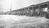
Kentucky Dam was completed and its gates closed on August 30, 1944, and its first generator went online September 14, 1944. The project cost nearly $118 million, making it the most expensive TVA dam project. Kentucky Dam's navigation lock was the first lock designed by TVA— the Corps of Engineers had designed the locks for previous TVA dam projects. The Corps of Engineers is designing the new lock, however, which was scheduled for completion in 2008.
Since Kentucky Dam is located in the New Madrid Seismic Zone
— which produced earthquakes of estimated magnitude 7.0 to 7.9 in 1811 — it is one of the few TVA dams built to withstand major earthquake
shocks. Emergency preparedness officials in Marshall County and McCracken County, Kentucky
(downstream from the dam) and a TVA spokesman discussed concerns of the public about the dam in 2005 in a local newspaper, The Paducah Sun
. The dam was regarded as well maintained. Experts suggested that any dam failure would probably occur in the earthen levees at the end of the concrete portion of the dam, and the subsequent release would start small and enlarge as water poured through it. It is not expected that a 50 feet (15.2 m) wall of water would suddenly go down the river. Instead, it would likely take at least six hours for the water level to rise above the Calvert City chemical plants. The floodwater should only reach the base of the Paducah floodwall.
The dam also carried a railroad line and two lanes of US 62
/641
at its crest. However, due to the planned lock expansion, two new crossings were built just downstream of the dam—a two-lane road bridge and a separate rail bridge. The new bridges were opened in late 2009.
Tennessee River
The Tennessee River is the largest tributary of the Ohio River. It is approximately 652 miles long and is located in the southeastern United States in the Tennessee Valley. The river was once popularly known as the Cherokee River, among other names...
on the county line between Livingston County
Livingston County, Kentucky
Livingston County is a county located in the U.S. state of Kentucky. As of 2000, the population was 9,804. Its county seat is Smithland. The county is named for Robert R. Livingston...
and Marshall County
Marshall County, Kentucky
Marshall County is a county located in the U.S. state of Kentucky. As of 2000, the population was 30,125. The 2007 Census Bureau population estimate was 31,258. Its county seat is Benton. It was a dry county until 2004, when residents of Calvert City voted to allow sales of liquor by the drink in...
in the U.S. state
U.S. state
A U.S. state is any one of the 50 federated states of the United States of America that share sovereignty with the federal government. Because of this shared sovereignty, an American is a citizen both of the federal entity and of his or her state of domicile. Four states use the official title of...
of Kentucky
Kentucky
The Commonwealth of Kentucky is a state located in the East Central United States of America. As classified by the United States Census Bureau, Kentucky is a Southern state, more specifically in the East South Central region. Kentucky is one of four U.S. states constituted as a commonwealth...
. The dam is the lowermost of nine dams on the river owned and operated by the Tennessee Valley Authority
Tennessee Valley Authority
The Tennessee Valley Authority is a federally owned corporation in the United States created by congressional charter in May 1933 to provide navigation, flood control, electricity generation, fertilizer manufacturing, and economic development in the Tennessee Valley, a region particularly affected...
, which built the dam in the late 1930s and early 1940s to improve navigation on the lower part of the river and reduce flooding on the lower Ohio
Ohio River
The Ohio River is the largest tributary, by volume, of the Mississippi River. At the confluence, the Ohio is even bigger than the Mississippi and, thus, is hydrologically the main stream of the whole river system, including the Allegheny River further upstream...
and Mississippi
Mississippi River
The Mississippi River is the largest river system in North America. Flowing entirely in the United States, this river rises in western Minnesota and meanders slowly southwards for to the Mississippi River Delta at the Gulf of Mexico. With its many tributaries, the Mississippi's watershed drains...
rivers. The dam impounds the Kentucky Lake
Kentucky Lake
Kentucky Lake is a major navigable reservoir along the Tennessee River in Kentucky and Tennessee. Created in 1944 by the Tennessee Valley Authority's impounding of the Tennessee River by Kentucky Dam, the lake is the largest artificial lake by surface area in the United States east of the...
of 160000 acres (64,749.8 ha), which is the largest of TVA's reservoirs and the largest artificial lake by area in the Eastern United States. A canal connects Kentucky Lake to nearby Lake Barkley
Lake Barkley
Lake Barkley, a reservoir in Livingston, Lyon, and Trigg counties in Kentucky and extending into Stewart and Houston counties in Tennessee, was impounded by the U.S. Army Corps of Engineers in 1966 upon the completion of Barkley Dam. Both the lake and the dam are named for Vice President Alben...
, created by Barkley Dam
Barkley Dam
Barkley Dam is a dam along the Cumberland River in Kentucky. Its construction, along with Kentucky Dam formed the Land Between the Lakes National Recreation Area by stopping the flow of the Cumberland and Tennessee Rivers, forming Lake Barkley and Kentucky Lake respectively.The dam and artificial...
on the Cumberland River
Cumberland River
The Cumberland River is a waterway in the Southern United States. It is long. It starts in Harlan County in far southeastern Kentucky between Pine and Cumberland mountains, flows through southern Kentucky, crosses into northern Tennessee, and then curves back up into western Kentucky before...
. The lakes run parallel for more than 50 miles (80 km), with the Land Between the Lakes National Recreation Area located between them.
Location
Kentucky Dam is located just over 22 miles (35.4 km) above the mouth of the Tennessee River, which empties into the Ohio River at Paducah, KentuckyPaducah, Kentucky
Paducah is the largest city in Kentucky's Jackson Purchase Region and the county seat of McCracken County, Kentucky, United States. It is located at the confluence of the Tennessee River and the Ohio River, halfway between the metropolitan areas of St. Louis, Missouri, to the west and Nashville,...
. After absorbing the Tennessee, the Ohio flows for another 46 miles (74 km) before emptying into the Mississippi River at Cairo, Illinois
Cairo, Illinois
Cairo is the southernmost city in the U.S. state of Illinois. It is the county seat of Alexander County. Cairo is located at the confluence of the Mississippi and Ohio rivers. The rivers converge at Fort Defiance State Park, an American Civil War fort that was commanded by General Ulysses S. Grant...
. The dam is approximately 20 miles (32.2 km) north of the Kentucky-Tennessee
Tennessee
Tennessee is a U.S. state located in the Southeastern United States. It has a population of 6,346,105, making it the nation's 17th-largest state by population, and covers , making it the 36th-largest by total land area...
border and 10 miles (16.1 km) southeast of the Kentucky-Illinois
Illinois
Illinois is the fifth-most populous state of the United States of America, and is often noted for being a microcosm of the entire country. With Chicago in the northeast, small industrial cities and great agricultural productivity in central and northern Illinois, and natural resources like coal,...
border. The city of Grand Rivers
Grand Rivers, Kentucky
Grand Rivers is a city in Livingston County, Kentucky, United States. The population was 343 at the 2000 census. It is part of the Paducah, KY-IL Micropolitan Statistical Area.-Geography:Grand Rivers is located at ....
is located northeast of the dam, and Gilbertsville
Gilbertsville, Kentucky
Gilbertsville is an unincorporated community in Marshall County, Kentucky, United States. Its elevation is 351 feet , and it is located at . It is known as the closest village to Kentucky Dam...
and Calvert City
Calvert City, Kentucky
Calvert City is a city in Marshall County, Kentucky, United States. The population was 2,701 at the 2000 census.-Geography:Calvert City is located at ....
are immediately downstream. Kentucky Lake stretches southward for 184 miles (296.1 km) across Kentucky and most of the length of Tennessee to the base of Pickwick Landing Dam
Pickwick Landing Dam
Pickwick Landing Dam is a hydroelectric dam on the Tennessee River in Hardin County, in the U.S. state of Tennessee. The dam is one of nine dams on the river owned and operated by the Tennessee Valley Authority, which built the dam in the 1930s as part of a New Deal-era initiative to create a...
, near the Tennessee-Alabama
Alabama
Alabama is a state located in the southeastern region of the United States. It is bordered by Tennessee to the north, Georgia to the east, Florida and the Gulf of Mexico to the south, and Mississippi to the west. Alabama ranks 30th in total land area and ranks second in the size of its inland...
line, and includes parts of Livingston, Marshall, Lyon
Lyon County, Kentucky
Lyon County is a county located in the U.S. state of Kentucky. As of 2000, the population was 8,080. Its county seat is Eddyville. Created from Caldwell County, Kentucky in 1854, the county was named for former Congressman Chittenden Lyon....
, Calloway
Calloway County, Kentucky
Calloway County is a county located in the U.S. state of Kentucky. It was formed in 1823. As of 2010, the population was 37,191. Its county seat is Murray, Kentucky. The county is named for Colonel Richard Callaway, one of the founders of Boonesborough...
, and Trigg
Trigg County, Kentucky
Trigg County is a county located in the U.S. state of Kentucky. It was formed in 1820. As of 2000, the population was 12,597. Its county seat is Cadiz. The county is named for Stephen Trigg, a frontier officer in the American Revolutionary War who died in the Battle of Blue Licks...
counties in Kentucky and parts of Humphreys
Humphreys County, Tennessee
Humphreys County is a county located in the U.S. state of Tennessee. As of 2000, the population was 17,929. The 2005 Census Estimate placed the population at 18,212. Its county seat is Waverly.-Geography:According to the U.S...
, Benton, Decatur, Stewart, Carroll
Carroll County, Tennessee
Carroll County is a county located in the U.S. state of Tennessee. As of 2010, the population was 28,522. Its county seat is Huntingdon. It was named for Governor William Carroll.-Geography:According to the U.S...
, Wayne
Wayne County, Tennessee
As of the census of 2010, there were 17,021 people, 5,822 households, and 4,321 families residing in the county. The population density was 23 people per square mile . There were 6,701 housing units at an average density of 9 per square mile...
, Henderson, Henry, Perry, Houston, and Hardin
Hardin County, Tennessee
Hardin County is a county located in the U.S. State of Tennessee. As of 2010, the population was 26,026. The Hardin County seat is Savannah. The county was named posthumously for Col. Joseph Hardin, a Revolutionary War soldier and a legislative representative for the Province of North Carolina and...
counties in Tennessee.
Barkley Dam, which is operated by the U.S. Army Corps of Engineers, is located along the Cumberland River
Cumberland River
The Cumberland River is a waterway in the Southern United States. It is long. It starts in Harlan County in far southeastern Kentucky between Pine and Cumberland mountains, flows through southern Kentucky, crosses into northern Tennessee, and then curves back up into western Kentucky before...
just opposite Lake City a few miles east of Kentucky Dam. The canal connecting Kentucky and Barkley Lakes joins Kentucky Lake approximately 3 miles (4.8 km) upstream from Kentucky Dam.
Capacity
Kentucky Dam is 206 feet (62.8 m) high, although over half the dam is submerged by water. At 8422 feet (2,567 m) long, Kentucky Dam is the longest dam on the Tennessee River and the longest in the TVA system. The dam has a generating capacity of 223,100 kilowatts, and its 24-bay spillway has a total discharge of 1050000 cuft/s. Kentucky Lake's 2064 miles (3,321.7 km) of shoreline, 160300 acres (64,871.2 ha) of water surface, and 4008000 acre.ft of flood storage are the most of any lake in the TVA system.Kentucky Dam is serviced by a 600 by navigation lock
Lock (water transport)
A lock is a device for raising and lowering boats between stretches of water of different levels on river and canal waterways. The distinguishing feature of a lock is a fixed chamber in which the water level can be varied; whereas in a caisson lock, a boat lift, or on a canal inclined plane, it is...
, soon to be supplemented by a larger 1200 by lock which will be better able to accommodate the long barge tows which navigate the river. A large industrial complex of chemical plants developed below the dam near Calvert City, Kentucky, due to the convenient barge transportation and inexpensive TVA electricity. The locks' lift raises and lowers vessels up to 75 feet (22.9 m) between Kentucky Lake and the lower part of the river.
Background and construction
Florence, Alabama
Florence is the county seat of Lauderdale County, Alabama, United States, in the northwestern corner of the state.According to the 2005 Census Bureau estimates, the city's population was 36,721....
. By the 1890s, a 5 feet (1.5 m) continuous channel had been secured, but was still deemed insufficient for major river traffic. The U.S. Army Corps of Engineers conducted an extensive survey of the lower river in the early 1900s, and recommended constructing a dam at Aurora Landing (roughly 20 miles (32.2 km) above the present site), but the project was never funded. In the 1930s, the Tennessee Valley Authority sought to create a continuous minimum 9 feet (2.7 m) channel along the entirety of the river from Paducah to Knoxville
Knoxville, Tennessee
Founded in 1786, Knoxville is the third-largest city in the U.S. state of Tennessee, U.S.A., behind Memphis and Nashville, and is the county seat of Knox County. It is the largest city in East Tennessee, and the second-largest city in the Appalachia region...
. The Authority also sought to help control flooding on the lower Mississippi River, especially in the aftermath of the Ohio River flood of 1937
Ohio River flood of 1937
The Ohio River flood of 1937 took place in late January and February 1937. With damage stretching from Pittsburgh to Cairo, Illinois, one million persons were left homeless, with 385 dead and property losses reaching $500 million...
, as research had shown that 4% of the water in the lower Mississippi originates in the Tennessee River watershed. TVA surveyed the lower part of the river and considered the Aurora Landing site, but eventually settled on the present site at river mile 22.4. The Kentucky Dam project was authorized May 23, 1938, and construction began July 1, 1938.
Big Sandy, Tennessee
Big Sandy is a town in Benton County, Tennessee, United States. The population was 518 at the 2000 census.-Geography:Big Sandy is located at ....
to protect the town from reservoir backwaters.
Kentucky Dam was completed and its gates closed on August 30, 1944, and its first generator went online September 14, 1944. The project cost nearly $118 million, making it the most expensive TVA dam project. Kentucky Dam's navigation lock was the first lock designed by TVA— the Corps of Engineers had designed the locks for previous TVA dam projects. The Corps of Engineers is designing the new lock, however, which was scheduled for completion in 2008.
Since Kentucky Dam is located in the New Madrid Seismic Zone
New Madrid Seismic Zone
The New Madrid Seismic Zone , sometimes called the New Madrid Fault Line, is a major seismic zone and a prolific source of intraplate earthquakes in the southern and midwestern United States, stretching to the southwest from New Madrid, Missouri.The New Madrid fault system was responsible for the...
— which produced earthquakes of estimated magnitude 7.0 to 7.9 in 1811 — it is one of the few TVA dams built to withstand major earthquake
Earthquake
An earthquake is the result of a sudden release of energy in the Earth's crust that creates seismic waves. The seismicity, seismism or seismic activity of an area refers to the frequency, type and size of earthquakes experienced over a period of time...
shocks. Emergency preparedness officials in Marshall County and McCracken County, Kentucky
McCracken County, Kentucky
McCracken County is a county located in the Jackson Purchase, the extreme western end of the U.S. state of Kentucky. As of 2000, the population was 65,514. The county seat, largest city, and only incorporated community is Paducah....
(downstream from the dam) and a TVA spokesman discussed concerns of the public about the dam in 2005 in a local newspaper, The Paducah Sun
The Paducah Sun
The Paducah Sun is a daily newspaper in Paducah, Kentucky owned by the family-run Paxton Media Group. The paper was formerly known as the Paducah Sun-Democrat. The publisher is Jim Paxton. Gary Adkisson is the general manager. Duke Conover is the executive editor.The Sun is the most-read newspaper...
. The dam was regarded as well maintained. Experts suggested that any dam failure would probably occur in the earthen levees at the end of the concrete portion of the dam, and the subsequent release would start small and enlarge as water poured through it. It is not expected that a 50 feet (15.2 m) wall of water would suddenly go down the river. Instead, it would likely take at least six hours for the water level to rise above the Calvert City chemical plants. The floodwater should only reach the base of the Paducah floodwall.
The dam also carried a railroad line and two lanes of US 62
U.S. Route 62
U.S. Route 62 runs from the US-Mexico border at El Paso, Texas to Niagara Falls, New York, near the United States-Canada border. It is the only east-west US Route that connects Mexico and Canada.Parts of U.S...
/641
U.S. Route 641
U.S. Route 641 is a spur of U.S. Route 41. It currently runs for 132 miles from Marion, Kentucky at U.S. Route 60 to Holladay, Tennessee at Interstate 40. Its passes through the states of Kentucky and Tennessee. US 641 does not, in any way, connect to its "parent" route, U.S. Route...
at its crest. However, due to the planned lock expansion, two new crossings were built just downstream of the dam—a two-lane road bridge and a separate rail bridge. The new bridges were opened in late 2009.
See also
- Dams and reservoirs of the Tennessee RiverDams and reservoirs of the Tennessee RiverThe Tennessee Valley Authority operates the Tennessee River system to provide a wide range of public benefits: year-round navigation, flood damage reduction, affordable electricity, improved water quality and water supply, recreation, and economic growth....
- List of crossings of the Tennessee River