
Kemmangundi
Encyclopedia
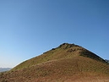
Kemmannugundi is a hill station
in Tarikere
taluk of Chikkamagaluru
district in the state of Karnataka
, India
. It is 1434m above sea level. This was the summer retreat of Krishnaraja Wodeyar IV and as a mark of respect to the king, it is also known as Sri Krishnarajendra Hill Station. The station is ringed by the Baba Budan Giri Range, with cascades, mountain streams, and lush vegetation, Kemmangundi’s has ornamental gardens and mountains and valleys views. There is a spectacular sunset view from the Raj Bhavan.
by road. The nearest National Highways, NH-206 or NH-48, connect to Bengaluru. There is another route via Mullayanagiri, a scenic drive.


700 to 1200 (for an up and down trip depending on the no of people).
, a deviation takes one to Kallathi falls. It is also known as Kallathigiri falls and Kalahasthi falls. Water cascades from a height of 122 metres and the temple here is attributed to times of the Vijayanagar
empire. According to a local legend, this place is associated with the Hindu
sage, Agastya
.
Hill station
A hill station is a town located at a higher elevation than the nearby plain or valley. The term was used mostly in colonial Asia , but also in Africa , for towns founded by European colonial rulers as refuges from the summer heat, up where temperatures are cooler...
in Tarikere
Tarikere
Tarikere is a taluk in Chikmagalur district in the state of Karnataka of India. The headquarters of Tarikere taluk is a town of the same name. The town has derived its name from number of water tanks by which the town is surrounded namely, Chikkere, Doddakere, Dalavikere,...
taluk of Chikkamagaluru
Chikkamagaluru
Chikmagalur is a town located in Chikkamagaluru district in the Indian state of Karnataka. Located in the foothills of Mullayanagiri range chikmagalur is famous for the coffee, it is known as the coffee land of karnataka. it has international school called ambar valley and a star resort by name...
district in the state of Karnataka
Karnataka
Karnataka , the land of the Kannadigas, is a state in South West India. It was created on 1 November 1956, with the passing of the States Reorganisation Act and this day is annually celebrated as Karnataka Rajyotsava...
, India
India
India , officially the Republic of India , is a country in South Asia. It is the seventh-largest country by geographical area, the second-most populous country with over 1.2 billion people, and the most populous democracy in the world...
. It is 1434m above sea level. This was the summer retreat of Krishnaraja Wodeyar IV and as a mark of respect to the king, it is also known as Sri Krishnarajendra Hill Station. The station is ringed by the Baba Budan Giri Range, with cascades, mountain streams, and lush vegetation, Kemmangundi’s has ornamental gardens and mountains and valleys views. There is a spectacular sunset view from the Raj Bhavan.
Origin of name
Kemmannugundi (or Kemmannagundi) derives its name from three Kannada words - Kempu (red), mannu (soil) and gundi (pit) and means a place with red soil.Road
Kemmannugundi is 53 km from Chickmagalore and 20 km from LingadahalliLingadahalli
Lingadahalli is a village in Tarikere Taluk, Chikkamagaluru District, Karnataka, India.-Demographics:Lingayatism is the major religion in the area...
by road. The nearest National Highways, NH-206 or NH-48, connect to Bengaluru. There is another route via Mullayanagiri, a scenic drive.
History
Kemmannugundi was established as the summer retreat of Krishnaraja Wodeyar IV. He later donated this resort to the Government of Karnataka. The Horticultural Department of Karnataka now develops and maintains the resort and its surroundings.Landmarks
Z point
Z point is a vantage point at Kemmangundi and can be reached by a steep uphill trek of about 45 minutes from Raj Bhavan and is another place from which to view the sunrise. Shanthi Falls near Kemmangundi can be visitedRose garden
Rose garden is a garden of roses maintained by the Horticultural Department. Many varieties of roses are cultivated there.Hebbe Falls
A downhill trek of about 8 km from Raj Bhavan takes one to Hebbe Falls where water streams down from a height of 168 meters in two stages to form Dodda Hebbe (Big Falls) and Chikka Hebbe (Small Falls). Jeeps are available from one particular point to Hebbe falls and they charge around INRINR
- Codes :INR is:* the ISO 4217 currency code of the Indian rupee * the Federal Aviation Administration location identifier of the McKinley National Park Airport, McKinley Park, Alaska, United States...
700 to 1200 (for an up and down trip depending on the no of people).
Kallathi falls
Kallathi falls is about 10 km. from Kemmangundi. On the road from Kemmangundi to TarikereTarikere
Tarikere is a taluk in Chikmagalur district in the state of Karnataka of India. The headquarters of Tarikere taluk is a town of the same name. The town has derived its name from number of water tanks by which the town is surrounded namely, Chikkere, Doddakere, Dalavikere,...
, a deviation takes one to Kallathi falls. It is also known as Kallathigiri falls and Kalahasthi falls. Water cascades from a height of 122 metres and the temple here is attributed to times of the Vijayanagar
Vijayanagara Empire
The Vijayanagara Empire , referred as the Kingdom of Bisnaga by the Portuguese, was an empire based in South Indian in the Deccan Plateau region. It was established in 1336 by Harihara I and his brother Bukka Raya I of the Yadava lineage. The empire rose to prominence as a culmination of attempts...
empire. According to a local legend, this place is associated with the Hindu
Hindu
Hindu refers to an identity associated with the philosophical, religious and cultural systems that are indigenous to the Indian subcontinent. As used in the Constitution of India, the word "Hindu" is also attributed to all persons professing any Indian religion...
sage, Agastya
Agastya
Agastya was a Tamil/Vedic Siddhar or sage. Agastya and his clan are also generally credited with uncovering many mantras of the Rig Veda, the earliest and most revered Hindu scripture, in the sense of first having the mantras revealed in his mind by the Supreme Brahman...
.