
Kekaha Kai State Park
Encyclopedia
Kona District, Hawaii
Kona is the name of a moku or district on the Big Island of Hawaii in the State of Hawaii. In the current system of administration of Hawaii County, the moku of Kona is divided into North Kona District and South Kona District . The term "Kona" is sometimes used to refer to its largest town,...
on the island of Hawaii
Hawaii (island)
The Island of Hawaii, also called the Big Island or Hawaii Island , is a volcanic island in the North Pacific Ocean...
. It includes Mahaiula Beach, Makalawena Beach and Kua Bay. The name comes from ke kaha kai which means "the shore line" in the Hawaiian language
Hawaiian language
The Hawaiian language is a Polynesian language that takes its name from Hawaii, the largest island in the tropical North Pacific archipelago where it developed. Hawaiian, along with English, is an official language of the state of Hawaii...
.
The northern section of the park is on Maniniowali beach at 19°48′36"N 156°2′24"W, which is normally called Kua Bay since it is easier to pronounce.
The wetland
Wetland
A wetland is an area of land whose soil is saturated with water either permanently or seasonally. Wetlands are categorised by their characteristic vegetation, which is adapted to these unique soil conditions....
area behind Makalawena beach (the shore of Puu Alii Bay)
is listed as a National Natural Landmark
National Natural Landmark
The National Natural Landmark program recognizes and encourages the conservation of outstanding examples of the natural history of the United States. It is the only natural areas program of national scope that identifies and recognizes the best examples of biological and geological features in...
.
It is known as Ōpaeula Pond (Hawaiian for "red shrimp
Halocaridina
Halocaridina rubra is a small red shrimp of the family Atyidae, with the common Hawaiian name .-Description and distribution:...
"), and was the site of an old fishing village of 7 or 8 houses, wiped out in the 1946 tsunami.
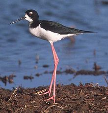
Its 12 acre (4.9 ha) provide one of the last remaining nesting grounds of the āeo (Hawaiian Stilt
Black-winged Stilt
The Black-winged Stilt or Common Stilt is a widely distributed very long-legged wader in the avocet and stilt family . Opinions differ as to whether the birds treated under the scientific name H. himantopus ought to be treated as a single species and if not, how many species to recognize...
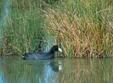
, Himantopus mexicanus knudseni), the alae keokeo (Hawaiian Coot
Hawaiian Coot
The Hawaiian Coot or alae keokeo is a species of bird in the rail family, Rallidae, that is endemic to Hawaii....
, Fulica alai), and the only known breeding area for the aukuu (Black-crowned Night Heron
Black-crowned Night Heron
The Black-crowned Night Heron commonly abbreviated to just Night Heron in Eurasia, is a medium-sized heron found throughout a large part of the world, except in the coldest regions and Australasia .-Description:Adults are...
, Nycticorax nycticorax hoactli) in Hawaii.
It is located at coordinates 19°47′32"N 156°1′31"W, in the privately-owned area between the two sections of the state park.
The park is open 9:00 am – 7:00 pm daily except Wednesdays.
A paved road 2.6 mi (4.2 km) North of Kona International Airport
Kona International Airport
Kona International Airport at Keāhole is an airport on the Island of Hawaii, in Kalaoa CDP, Hawaii County, Hawaii, United States. The airport serves leeward, or Western Hawaii island, including the town of Kailua-Kona and the major resorts of the North Kona and South Kohala districts.- History...
leads to Maniniowali (Kua Bay), and an unpaved lava road leads to Mahaiula.
The Mahaiula section has a sandy beach and dune with a picnic area. A 4.5 mi (7.2 km) hike north on the historic coastal trail, Ala Kahakai
Ala Kahakai National Historic Trail
Ala Kahakai National Historic Trail is a long trail located on the island of Hawaii. It is not yet a continuous "trail", but can be accessed at several broken segments along the coastline of the Big Island. The trail was established to access the traditional Ancient Hawaiian culture along with...
, connects Mahaiula and Kua Bay. A hike to the summit of Puu Kuili, a 342 ft (104.2 m) cinder cone
Cinder cone
According to the , Cinder Cone is the proper name of 1 cinder cone in Canada and 7 cinder cones in the United States:In Canada: Cinder Cone In the United States:...
, offers an excellent view of the coastline.