
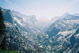
Kaweah Gap
Encyclopedia
The Kaweah Gap is the lowest east-west pass
through the Great Western Divide
, in Sequoia National Park
, California
, USA. The High Sierra Trail
is routed through this pass.
Mountain pass
A mountain pass is a route through a mountain range or over a ridge. If following the lowest possible route, a pass is locally the highest point on that route...
through the Great Western Divide
Great Western Divide
The Great Western Divide is a Sierra Nevada mountain range that forms part of the border between the Kings Canyon and Sequoia National Parks. The High Sierra Trail crosses the range at Kaweah Gap from Sequoia National Park.- References :...
, in Sequoia National Park
Sequoia National Park
Sequoia National Park is a national park in the southern Sierra Nevada east of Visalia, California, in the United States. It was established on September 25, 1890. The park spans . Encompassing a vertical relief of nearly , the park contains among its natural resources the highest point in the...
, California
California
California is a state located on the West Coast of the United States. It is by far the most populous U.S. state, and the third-largest by land area...
, USA. The High Sierra Trail
High Sierra Trail
The High Sierra Trail is a hiking trail in Sequoia National Park, California. The trail crosses the Sierra Nevada from west to east.From the plateau of the Giant Forest at Crescent Meadow the trail travels high on the northern wall of the canyon of the Middle Fork of the Kaweah River to Bearpaw...
is routed through this pass.