
Katol
Encyclopedia
Katol is a city and a municipal council
in Nagpur district
of Maharashtra
state, India
. It is the administrative headquarters of Katol taluka, one of the 14 talukas of this district. Being located in orange belt it is a major centre for orange trading.
, Katol had a population of 37,417. Males constitute 52% of the population and females 48%. Katol has an average literacy rate of 77%, higher than the national average of 59.5%: male literacy is 82%, and female literacy is 72%. In Katol, 12% of the population is under 6 years of age.
, and they still produce excellent oranges and mangoes.
 But cotton is the staple of Katol trade. In the year 1905-06 26,723 carts of raw uncleaned cotton were sold in the market, and that number is liable to be exceeded in years of heavy harvest, for the town draws produce from the rich valleys of the Jam and Wardha rivers and from many villages of the Amravati
and Wardha
Districts. There are now four ginning factories at work, and three of these have presses also. They are fitted with 216 gins, which in 1905-06 turned out 32,000 bales (or 512,000 maunds) of cleaned cotton.
Katol has, on the whole, the poorest soils of the four tahsils as regards composition, although it has all the kali soils of the first class in the District. The percentages of the various soils are 2 for kali, 55.9 for morand, 28.5 for khardi and 13.2; for bardi. Nevertheless, from an agricultural point of view Katol is the most advanced of the four tahsils, and its lands produce kharif crops as valuable as the wheat of the other tahsils. The cultivators are intelligent and enterprising to an unusual degree and spend much time and money on improvements to their fields. Of the 17000 acres (68.8 km²) of irrigated garden land at settlement 8000 acres (32.4 km²) were in Katol. Of the total area of 476000 acres (1,926.3 km²) at settlement, 358,000 were occupied and 332,000 were in cultivation. The actual area cropped has risen since the thirty years' settlement from 265000 acres (1,072.4 km²) to 337000 acres (1,363.8 km²) in 1906-07, an increase of 29 per cent. which is the largest in any tahsil. Of the total area 75 per cent. is occupied, 8.7 is scrub jungle,4.2 tree-forest, and 11.8 unculturable.
Once Katol and Kalmeshwar talukas in Nagpur district had enough groundwater to irrigate their orange orchards. But in the past decade or so, the water table has gone down to 700-900 feet in almost the entire belt and digging of bore wells has become totally uneconomical. Farmers here have now switched to conventional dry land farming of cotton and soyabean, with the area under orange cultivation reduced almost to half.
 Chandi
ka Devi Mandir — The temple is believed to have been built during the reign of one king Candrahasa, who is supposed to have ruled over this territory in the dim and distant past. The construction of the temple is. in the Hemadpanthi
style. It is situated in the old Basti. The 'Gabhara', which contains the idol of the goddess, measures 9.290 m.2 (10' x 10'). It is beautifully carved out of black rock and is in a standing position. On either side of the entrance to the 'Gabhara' are two images in standing posture which appear to be the bodyguards of the goddess Candika. Outside is the ' Sabhamandap' having windows on all the four sides which serve as inlets for the sunlight. In the centre exactly facing the goddess is a 'Honikunda' housed by a little dome. On the 'Mandap' wall, to the left of the goddess, is engraved the image of Lord Gajanan with exquisite skill. Against the outer side of the Mandap-walls are carved the images of animals, wild as well as domestic, and numerous deities which add a tinge of glory and glamour to the solid and grave structure of the building. The architectural designs speak eloquently of the architects of those times. In Navratra, Sardotsava is celebrated with great éclat when thousands of people gather to pay homage to the goddess.
Sharada Mandir — The idol is supposed to be ' Svayambhu'. It is a small building housing two images of the same goddess of unequal size. The images depict a sort of crude and rough architecture. In front of the temple is a tank of water of the size of a square measuring 37.161 m.2 (20' x 20'), whose water, it is said, never dries up. The place is venerated by the Hindus as a ' Tirtha Ksetra'. By the side of the tank is another small temple which houses the images of Maruti, Ganapati and Sivling. To the left of the Sarada Mandir is housed yet another Sivling by the side of which are three small samadhis of unknown persons. Two fairs, one on the occasion of Sardotsava and the other on Caitra Suddha 15th, are held when devotees of the goddess gather in large numbers.
Shiv Mandir — The Mandir is situated on the southern bank of a beautiful tank, now let on lease to the Government for pisciculture, with a lovely hillock at the hack and a giant pimpal tree in the front. The inner shrine or 'Gabhara' of the temple is 5.945 m.2 (8' x 8') with Ling occupying the central position. The Ling is donned with a brass plaque. On the wall facing the visitor are engraved the images of innumerable deities in beautiful and attractive designs. Outside is the 'Mandap' of the temple enclosed on all the four sides with walls having a single entrance in the front. It is used to deliver Kirtans and hold religious discourses in praise of the God. To the south of the temple of Siv there is a temple of Maruti whose image is about 3.048 metres (10 ft) tall. The idol of Maruti has become the major attraction to the people. The pimpal tree protects under its shade one more Sivling and an image of Nandi both carved out of black stone. The natural surroundings like the tank, the hillock and the pimpal tree provide an excellent setting and add charm and beauty to the temple. Especially the evenings, at the time of sunset, are lively and pleasant. It has become a good spot of recreation.
Municipal council
A municipal council is the local government of a municipality. Specifically the term can refer to the institutions of various countries that can be translated by this term...
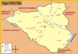
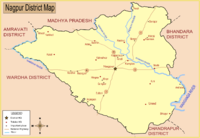
in Nagpur district
Nagpur District
Nagpur district is a district in the Vidarbha region of Maharashtra state in central India. The city of Nagpur is the district headquarters. The district is part of Nagpur Division....
of Maharashtra
Maharashtra
Maharashtra is a state located in India. It is the second most populous after Uttar Pradesh and third largest state by area in India...
state, India
India
India , officially the Republic of India , is a country in South Asia. It is the seventh-largest country by geographical area, the second-most populous country with over 1.2 billion people, and the most populous democracy in the world...
. It is the administrative headquarters of Katol taluka, one of the 14 talukas of this district. Being located in orange belt it is a major centre for orange trading.
Geography
Katol is located at 21.27°N 78.58°E. It has an average elevation of 417 metres (1368 ft).36 miles to the west of Nagpur with which it is connected by a fair road, which passes also through the town of Kalmeshwar. Beyond Katol this road goes to Warud in Amaravati District via Jalalkheda. Paradshinga the next village on this road is famous for late Saint Anusayamata temple. earlier this road was a mere surface track running into the Amraoti District. The town now includes the large adjoining village of Peth Budhwar, which lies on the Jam, a tributary of the Wardha river.The population of both was 7040 in 1891 and 7313 in 1901, but as the town is the trade centre of a wide cotton-growing tract it has grown considerably since last census. The old town-site is crowded, lying in a hollow and traversed only by narrow crooked lanes. But the recent trend of extension has been towards the higher ground on the south-east where the cotton factories stand.Demographics
As of 2001 India censusCensus
A census is the procedure of systematically acquiring and recording information about the members of a given population. It is a regularly occurring and official count of a particular population. The term is used mostly in connection with national population and housing censuses; other common...
, Katol had a population of 37,417. Males constitute 52% of the population and females 48%. Katol has an average literacy rate of 77%, higher than the national average of 59.5%: male literacy is 82%, and female literacy is 72%. In Katol, 12% of the population is under 6 years of age.
History
In Dvapara Yuga, during the reign of Raja Chandrahasa its name was Kuntalapur. Katol is also mentioned in the Ashwamedh canto of the Mahabharat as Kuntalapur. It possesses two of the Hemadpanthi temples which are said to date from the days of Rawan and to have been built in one night by his demons. The mud fort dates from the time of the Gond dynasty, and in the time of Dharmaji Bhonsla it was held by a Pindari confederacy which paid more or less regular tribute to the Raja and protected the country side from other raiding bands.Civic administration
The Corporation of Katol (previously Kuntlapur) is the Oldest Municipal Institution in India established on the year 1919. Katol is an ancient town but it reached the first stage of modern municipal development only in 1905 when it was notified as a Town-Fund area. For the first year its income was only Rs. 4761, but it has now risen to about Rs. 7176. Its prosperity depends chiefly on cotton-trading, and daring the past two years most of the municipal income has for that reason been expended on a cotton-market, now practically complete. This is a large enclosure of about 10 acres (40,468.6 m²), securely fenced, and provided with a weighing-shed, well, water-trough, young shade-trees, and an arc-light. Within the enclosure, round the central market square, several substantial shops are being erected by merchants.Trade
The weekly market of Katol has long been important and is now attended by from 6000 to 8000 people. Commodities of all kinds are dealt in but the bazar is more especially important as being the second largest cattle-market in the tahsil. In the month of Ashvin (October) the Saraswati fair (Navaratra) is held and is usually attended by about 20,000 people a day. In former days the gardens of the town were, noted for their growth of fine & world-famous ganjaGanja
Ganja is Azerbaijan's second-largest city with a population of around 313,300. It was named Yelizavetpol in the Russian Empire period. The city regained its original name—Ganja—from 1920–1935 during the first part of its incorporation into the Soviet Union. However, its name was changed again and...
, and they still produce excellent oranges and mangoes.
Amravati
Amravati is a city in the state of Maharashtra, India and the seventh most populous metropolitan area in Maharashtra. It is also the administrative headquarters of the Amravati district...
and Wardha
Wardha
Wardha is a city and a municipal council in Wardha district in the Indian state of Maharashtra. It is the administrative headquarters of Wardha district. Wardha gets its name from the Wardha River which flows at the North, West and South boundaries of district. Founded in 1866, the town is now an...
Districts. There are now four ginning factories at work, and three of these have presses also. They are fitted with 216 gins, which in 1905-06 turned out 32,000 bales (or 512,000 maunds) of cleaned cotton.
Agriculture
The Katol tahsil has a total area of 800 square miles (2,072 km²), of which 56 are comprised in Government forest. It is remarkable for the abrupt contrasts of stony upland and fertile plain which it presents. It is said of the Katol tahsil, as doubtless may have been said of stony regions in various parts of the world, that the Creator of the Universe, having completed the construction of the world, had a residue of rough materials, stones and rubbish, which he threw down on to the nearest tract of country to his hand at the time, and that this happened to be the Katol country, But these celestial rubbish heaps have proved a blessing to the country in which they have fallen. They have served to enclose and protect from erosion the deep lowland which they encircle, and the low country between them, embanked, as it were, by Nature's hard seems to increase rather than diminish in fertility. The prosperity, industry, and commercial activity generally prevailing in this tahsil, are the material evidences which shew that in this region of the District, Nature, despite a rugged exterior, has been not niggardly of her bounties.Katol has, on the whole, the poorest soils of the four tahsils as regards composition, although it has all the kali soils of the first class in the District. The percentages of the various soils are 2 for kali, 55.9 for morand, 28.5 for khardi and 13.2; for bardi. Nevertheless, from an agricultural point of view Katol is the most advanced of the four tahsils, and its lands produce kharif crops as valuable as the wheat of the other tahsils. The cultivators are intelligent and enterprising to an unusual degree and spend much time and money on improvements to their fields. Of the 17000 acres (68.8 km²) of irrigated garden land at settlement 8000 acres (32.4 km²) were in Katol. Of the total area of 476000 acres (1,926.3 km²) at settlement, 358,000 were occupied and 332,000 were in cultivation. The actual area cropped has risen since the thirty years' settlement from 265000 acres (1,072.4 km²) to 337000 acres (1,363.8 km²) in 1906-07, an increase of 29 per cent. which is the largest in any tahsil. Of the total area 75 per cent. is occupied, 8.7 is scrub jungle,4.2 tree-forest, and 11.8 unculturable.
Once Katol and Kalmeshwar talukas in Nagpur district had enough groundwater to irrigate their orange orchards. But in the past decade or so, the water table has gone down to 700-900 feet in almost the entire belt and digging of bore wells has become totally uneconomical. Farmers here have now switched to conventional dry land farming of cotton and soyabean, with the area under orange cultivation reduced almost to half.
Public Institutions
The educational institutions comprise an English middle school with 250 pupils, two branch schools and a girls, school. The buildings are now too small for the town's requirements and a large new school is shortly to be built on the plateau to the south-east across which the main road is to be diverted. Here too a new post and telegraph office is to be built and a new tahsil court. A portion of the open ground has been utilised for a Town Hall, now nearing completion, the funds for which were raised by subscription, and on another portion a small Club House is being erected. Close to these sites stands the present tahsili, which is to be converted into a police Station-house, and the dispensary, which has a male and a female ward with 6 beds attached to it.Ancient Temples
Chandi
Chandi or Chandika is the supreme Goddess of Devi Mahatmya also known as Chandi or Durga Sapthashati. Chandi is described as the Supreme reality who is a combination of Mahakali, Maha Lakshmi and Maha Saraswati...
ka Devi Mandir — The temple is believed to have been built during the reign of one king Candrahasa, who is supposed to have ruled over this territory in the dim and distant past. The construction of the temple is. in the Hemadpanthi
Hemadpanthi
Hemadpanthi Sculpture is an architectural form or a style, which is named after its introducer and founder, the prime minister named Hemadpant in the court of Seuna Yadavas of Devagiri. The period of discovery was during the 13th Century in Maharashtra. Main ingredients in the construction include...
style. It is situated in the old Basti. The 'Gabhara', which contains the idol of the goddess, measures 9.290 m.2 (10' x 10'). It is beautifully carved out of black rock and is in a standing position. On either side of the entrance to the 'Gabhara' are two images in standing posture which appear to be the bodyguards of the goddess Candika. Outside is the ' Sabhamandap' having windows on all the four sides which serve as inlets for the sunlight. In the centre exactly facing the goddess is a 'Honikunda' housed by a little dome. On the 'Mandap' wall, to the left of the goddess, is engraved the image of Lord Gajanan with exquisite skill. Against the outer side of the Mandap-walls are carved the images of animals, wild as well as domestic, and numerous deities which add a tinge of glory and glamour to the solid and grave structure of the building. The architectural designs speak eloquently of the architects of those times. In Navratra, Sardotsava is celebrated with great éclat when thousands of people gather to pay homage to the goddess.
Sharada Mandir — The idol is supposed to be ' Svayambhu'. It is a small building housing two images of the same goddess of unequal size. The images depict a sort of crude and rough architecture. In front of the temple is a tank of water of the size of a square measuring 37.161 m.2 (20' x 20'), whose water, it is said, never dries up. The place is venerated by the Hindus as a ' Tirtha Ksetra'. By the side of the tank is another small temple which houses the images of Maruti, Ganapati and Sivling. To the left of the Sarada Mandir is housed yet another Sivling by the side of which are three small samadhis of unknown persons. Two fairs, one on the occasion of Sardotsava and the other on Caitra Suddha 15th, are held when devotees of the goddess gather in large numbers.
Shiv Mandir — The Mandir is situated on the southern bank of a beautiful tank, now let on lease to the Government for pisciculture, with a lovely hillock at the hack and a giant pimpal tree in the front. The inner shrine or 'Gabhara' of the temple is 5.945 m.2 (8' x 8') with Ling occupying the central position. The Ling is donned with a brass plaque. On the wall facing the visitor are engraved the images of innumerable deities in beautiful and attractive designs. Outside is the 'Mandap' of the temple enclosed on all the four sides with walls having a single entrance in the front. It is used to deliver Kirtans and hold religious discourses in praise of the God. To the south of the temple of Siv there is a temple of Maruti whose image is about 3.048 metres (10 ft) tall. The idol of Maruti has become the major attraction to the people. The pimpal tree protects under its shade one more Sivling and an image of Nandi both carved out of black stone. The natural surroundings like the tank, the hillock and the pimpal tree provide an excellent setting and add charm and beauty to the temple. Especially the evenings, at the time of sunset, are lively and pleasant. It has become a good spot of recreation.