
Karuah, New South Wales
Encyclopedia
Karuah is a predominantly rural locality of both the Port Stephens and Great Lakes Councils in the Hunter Region of New South Wales
, Australia
. It is thought that the name means 'native plum tree' in the local Aboriginal
dialect.
into which the Karuah River feeds.
and straddles the Karuah River. Most of the village, which occupies only about 0.7 square kilometre (0.270271511014775 sq mi) of the suburb's total area of 74.7 km² (28.8 sq mi), lies within the Port Stephens LGA. It includes the largest Aboriginal community in the Port Stephens LGA and, at the 2006 Census, had a population of approximately 857. The rest of the suburb's population live in the rural properties which surround the village.
The Karuah bridge was built and opened in December 1957. In 2004, the Karuah Bypass was opened which, as part of the AusLink
program, speeds up car and truck travel times past the township.
The Karuah township has long been known for its oyster
s, and a number of oyster shops line the old Pacific Highway within the town.
New South Wales
New South Wales is a state of :Australia, located in the east of the country. It is bordered by Queensland, Victoria and South Australia to the north, south and west respectively. To the east, the state is bordered by the Tasman Sea, which forms part of the Pacific Ocean. New South Wales...
, Australia
Australia
Australia , officially the Commonwealth of Australia, is a country in the Southern Hemisphere comprising the mainland of the Australian continent, the island of Tasmania, and numerous smaller islands in the Indian and Pacific Oceans. It is the world's sixth-largest country by total area...
. It is thought that the name means 'native plum tree' in the local Aboriginal
Indigenous Australians
Indigenous Australians are the original inhabitants of the Australian continent and nearby islands. The Aboriginal Indigenous Australians migrated from the Indian continent around 75,000 to 100,000 years ago....
dialect.
Geography
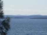
The suburb is split between the Port Stephens and Great Lakes councils with most (approximately 51%) located in the Port Stephens Council area. Karuah township is also split between the two councils with almost all of the township located in Port Stephens Council. The Karuah River, which runs approximately north to south through the centre of the suburb, forms the border between the two councils within the suburb. Karuah is located at the north-western corner of Port StephensPort Stephens
Port Stephens is a large natural harbour located about north-east of Sydney in New South Wales, Australia. It lies wholly within the Port Stephens Local Government Area although its northern shoreline forms the boundary between the Port Stephens and Great Lakes LGAs...
into which the Karuah River feeds.
Demographics
The largest settlement within the suburb is the village of Karuah, which is on the old Pacific HighwayPacific Highway (Australia)
The Pacific Highway is a major transport route along part of the east coast of Australia and is part of Australia's national route 1.It is 960 km long and links Sydney, the capital of New South Wales, to Brisbane, the capital of Queensland, along the coast, via Gosford, Newcastle, Taree, Port...
and straddles the Karuah River. Most of the village, which occupies only about 0.7 square kilometre (0.270271511014775 sq mi) of the suburb's total area of 74.7 km² (28.8 sq mi), lies within the Port Stephens LGA. It includes the largest Aboriginal community in the Port Stephens LGA and, at the 2006 Census, had a population of approximately 857. The rest of the suburb's population live in the rural properties which surround the village.
The Karuah bridge was built and opened in December 1957. In 2004, the Karuah Bypass was opened which, as part of the AusLink
AusLink
AusLink was an Australian Government land transport funding program, established in June 2004 and administered by the Department of Transport and Regional Services. In 2009 it was replaced with the Nation Building Program under the Nation Building Program Act 2009...
program, speeds up car and truck travel times past the township.
The Karuah township has long been known for its oyster
Oyster
The word oyster is used as a common name for a number of distinct groups of bivalve molluscs which live in marine or brackish habitats. The valves are highly calcified....
s, and a number of oyster shops line the old Pacific Highway within the town.