
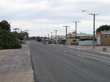
Karoonda, South Australia
Encyclopedia
Murray Mallee
The Murray Mallee is the grain-growing and sheep-farming area of South Australia bounded to the north and west by the Murray River, to the east by the Victorian border, and extending about 50 km south of the Mallee Highway....
region of South Australia
South Australia
South Australia is a state of Australia in the southern central part of the country. It covers some of the most arid parts of the continent; with a total land area of , it is the fourth largest of Australia's six states and two territories.South Australia shares borders with all of the mainland...
at geographic coordinates 35°05′S 139°53′E (60 km northeast of Murray Bridge
Murray Bridge, South Australia
Murray Bridge is the fourth most populous city in South Australia after Adelaide, Mount Gambier and Whyalla. It is located east-southeast of Adelaide and north of Meningie....
). Karoonda takes its name from the Aboriginal word for "winter camp".
It was founded on wheat
Wheat
Wheat is a cereal grain, originally from the Levant region of the Near East, but now cultivated worldwide. In 2007 world production of wheat was 607 million tons, making it the third most-produced cereal after maize and rice...
growing early in the 20th century (proclaimed on 11 December 1913), but the cleared land is also suitable for raising merino
Merino
The Merino is an economically influential breed of sheep prized for its wool. Merinos are regarded as having some of the finest and softest wool of any sheep...
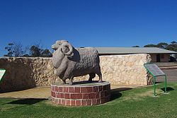
sheep. The Karoonda Development Group instigated and built this larger-than-life sculpture of a Merino ram in the park in the main street to emphasise this. There are even seats with rams heads dotted around the town. A number of other agricultural and horticultural industries are now also represented in the district. Each year the Karoonda Farm Fair is held, a two day event attracting over 10,000 visitors to the town.
Railways were built in 1911-1914 to open up the mallee, and Karoonda was a junction with branch lines to Waikerie
Waikerie, South Australia
Waikerie is a rural town in the Riverland region of South Australia on the south bank of the Murray River. At the 2006 census, Waikerie had a population of 1,744. The Sturt Highway passes to the south of the town at the top of the cliffs...
and Peebinga, both were closed in 1990, but the line from Tailem Bend
Tailem Bend, South Australia
Tailem Bend is a town on the Murray River in South Australia. The town was proclaimed in 1887, the year after the main railway came through. At the 2006 census, Tailem Bend had a population of 1,457....
to Loxton
Loxton, South Australia
Loxton is a town on the south bank of the River Murray in the Riverland region of South Australia. At the 2006 census, Loxton had a population of 3,431....
remains open and was converted from broad gauge
Broad gauge
Broad-gauge railways use a track gauge greater than the standard gauge of .- List :For list see: List of broad gauges, by gauge and country- History :...
to standard gauge
Standard gauge
The standard gauge is a widely-used track gauge . Approximately 60% of the world's existing railway lines are built to this gauge...
.
Karoonda briefly shot to international fame in 1930 when a meteorite
Karoonda meteorite
The Karoonda meteorite fell to earth on November 25, 1930 at 10:53 pm near the South Australian town of Karoonda.The CK chondrites were named for this meteorite.-External links:**...
fell to earth just to the east of the town on the night of 25 November.
Karoonda Area School was the first area school
Area school
In New Zealand and Australia, an area school is a school that takes children from kindergarten age all the way through to tertiary entrance exams . They tend to be built in small towns where the cost of separate primary and secondary schools cannot be justified....
in South Australia.
Karoonda is in the District Council of Karoonda East Murray
District Council of Karoonda East Murray
The District Council of Karoonda East Murray is a local government area in the Murray Mallee area of South Australia . The main council offices are in Karoonda.The council area covers 4,415 square kilometres and has a estimated population of 1193...
, the state electorate of Hammond and the federal Division of Barker
Division of Barker
The Division of Barker is an Australian Electoral Division in the south-east of South Australia.The division was created in 1903 and is named for Collet Barker, an early explorer of the region at the mouth of the Murray River...
.
Pioneer Park on East Terrace is being developed as a Malleelands Pioneer Railways and farm museum, with displays of harvest machinery , plows, railway rolling stock and facilities already in place. The Nature Trail & Bush Walk is adjacent.
Surrounding communities
| North: Perponda Perponda, South Australia Perponda is a settlement in South Australia. At the 2006 census, Perponda had a population of 192.... & Bowhill |
||
| West: Wynarka Wynarka, South Australia Wynarka is a very small town in South Australia southeast of Adelaide on the Karoonda Highway . Wynarka lies within the District Council of Karoonda East Murray.The name Wynarka is from the Aboriginal word meaning a strayer.... , Tailem Bend Tailem Bend, South Australia Tailem Bend is a town on the Murray River in South Australia. The town was proclaimed in 1887, the year after the main railway came through. At the 2006 census, Tailem Bend had a population of 1,457.... & Murray Bridge Murray Bridge, South Australia Murray Bridge is the fourth most populous city in South Australia after Adelaide, Mount Gambier and Whyalla. It is located east-southeast of Adelaide and north of Meningie.... |
Karoonda | East: Lowaldie, Borrika, Sandalwood Sandalwood, South Australia Sandalwood is a settlement in South Australia.... & Marama Marama, South Australia Marama is a town in the District Council of Karoonda East Murray near Karoonda. There is a town hall, post office and an automated telephone exchange. The postcode is 5307.... |
| South: Sherlock & Yumali Yumali, South Australia Yumali is a very small country town in South Australia 162km southeast of Adelaide on the Dukes Highway . Yumali belongs to the The Coorong District Council and is in the State electorate of Hammond and the Federal electorate of Barker.... |
South-East: Lameroo Lameroo, South Australia Lameroo is a town in the Murray Mallee region of South Australia. It is on the Mallee Highway about 40 km west of the Victorian border, or 210 km east of Adelaide. It is primarily a service town for the surrounding rural areas, growing grain and sheep... |