

Kamihayashi, Niigata
Encyclopedia
Villages of Japan
A is a local administrative unit in Japan.It is a local public body along with , , and . Geographically, a village's extent is contained within a prefecture....
located in Iwafune District
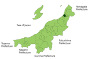
Iwafune District, Niigata
is a district located in Niigata, Japan.As of May 1, 2008, the district has an estimated population of 7,137. The total area is 309.47 km².The district currently has two villages.* Awashimaura* Sekikawa...
, Niigata
Niigata Prefecture
is a prefecture of Japan located on the island of Honshū on the coast of the Sea of Japan. The capital is the city of Niigata. The name "Niigata" literally means "new lagoon".- History :...
, Japan
Japan
Japan is an island nation in East Asia. Located in the Pacific Ocean, it lies to the east of the Sea of Japan, China, North Korea, South Korea and Russia, stretching from the Sea of Okhotsk in the north to the East China Sea and Taiwan in the south...
.
As of 2003, the village had an estimated population
Population
A population is all the organisms that both belong to the same group or species and live in the same geographical area. The area that is used to define a sexual population is such that inter-breeding is possible between any pair within the area and more probable than cross-breeding with individuals...
of 10,228 and a density
Population density
Population density is a measurement of population per unit area or unit volume. It is frequently applied to living organisms, and particularly to humans...
of 124.46 persons per km². The total area was 82.18 km².
On April 1, 2008 Kamihayashi, along with the towns of Sanpoku
Sanpoku, Niigata
was a town located in Iwafune District, Niigata, Japan.On April 1, 2008 Sanpoku, along with the town of Arakawa, and the villages of Asahi and Kamihayashi, all from Iwafune District, was merged into the city of Murakami....
and Arakawa
Arakawa, Niigata
was a town located in Iwafune District, Niigata, Japan.On April 1, 2008 Arakawa, along with the town of Sanpoku, and the villages of Asahi and Kamihayashi, all from Iwafune District, was merged into the city of Murakami....
, and the village of Asahi
Asahi, Niigata
was a village located in Iwafune District, Niigata, Japan.The village was named after the Asahi Mountains.As of 2005, the village had an estimated population of 11,836 and a density of 18.69 persons per km²...
, all from Iwafune District
Iwafune District, Niigata
is a district located in Niigata, Japan.As of May 1, 2008, the district has an estimated population of 7,137. The total area is 309.47 km².The district currently has two villages.* Awashimaura* Sekikawa...
, was merged into the city of Murakami
Murakami, Niigata
is a city located in northern Niigata, Japan.On April 1, 2008, the city merged with the towns of Sanpoku and Arakawa, and the villages of Asahi and Kamihayashi, all from Iwafune District....
.
Railway
- JR EastEast Japan Railway Companyis the largest passenger railway company in the world and one of the seven Japan Railways Group companies. The company name is officially abbreviated as JR East in English, and as in Japanese. The company's headquarters are in Yoyogi, Shibuya, Tokyo....
: Uetsu Main LineUetsu Main LineThe is a railway in the Tōhoku and Chūbu regions of Japan. Part of the East Japan Railway Company system, it connects Niitsu Station in the city of Niigata and Akita Station in Akita...
(Hirabayashi StationHirabayashi Station (Niigata)is a JR East railway station located in Murakami, Niigata Prefecture, Japan.-Adjacent stations:...
, Iwafunemachi StationIwafunemachi Stationis a JR East railway station located in Murakami, Niigata Prefecture, Japan.-Adjacent stations:...
)
Road
- Route 7Route 7 (Japan)National Route 7 is an important highway on the Sea of Japan side of the island of Honshū, Japan. It links the prefectural capitals of Niigata, Akita, and Aomori...
- Route 290Route 290 (Japan)National Route 290 is a national highway of Japan connecting Murakami, Niigata and Uonuma, Niigata in Japan, with a total length of 165.5 km ....
- Route 345Route 345 (Japan)National Route 345 is a national highway of Japan connecting Chūō-ku, Niigata and Yuza, Yamagata in Japan, with a total length of 212 km ....