

Kaitersberg
Encyclopedia
Bad Kötzting
-References:Notes...
in the Bavarian Forest
Bavarian Forest
thumb|The village of Zell in the Bavarian ForestThe Bavarian Forest is a wooded low-mountain region in Bavaria, Germany. It extends along the Czech border and is continued on the Czech side by the Šumava . Geographically the Bavarian Forest and Bohemian Forest are sections of the same mountain range...
in southern Germany
Germany
Germany , officially the Federal Republic of Germany , is a federal parliamentary republic in Europe. The country consists of 16 states while the capital and largest city is Berlin. Germany covers an area of 357,021 km2 and has a largely temperate seasonal climate...
. Its long ridge runs eastwards towards the Großer Arber.
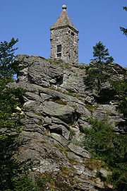
The highest peak on the ridge is the 1,132 metre high Großer Riedelstein
Großer Riedelstein
At sea level the Großer Riedelstein is the highest point on the Kaitersberg mountain ridge in the Bavarian Forest in southern Germany. Its rocky summit is decorated by a stone monument in memory of the poet, Maximilian Schmidt, known as "Forest Schmidt" .In summer the Großer Riedelstein is a...
with its Waldschmidt monument. On another peak, the Mittagstein
Mittagstein
The Mittagstein is a high mountain peak which rises in the middle of the Kaitersberg in the Bavarian Forest in southern Germany.On its forested summit is a chapel built in memory of those who have fallen in war. There is also a rocky viewpoint with views into the Zeller Valley and across to the...
, 1034 m (3,392.4 ft), is the Kötztinger Hütte, a restaurant and mountain hut. Other prominent peaks with odd rock formations made of gneiss
Gneiss
Gneiss is a common and widely distributed type of rock formed by high-grade regional metamorphic processes from pre-existing formations that were originally either igneous or sedimentary rocks.-Etymology:...
are the Kreuzfelsen
Kreuzfelsen
The Kreuzfelsen is a high rock outcrop, that forms the western cornerstone of the Kaitersberg mountain ridge in the Bavarian Forest in southern Germany...
, 999 m (3,277.6 ft), with its hilltop cross, and the Rauchröhren, (1044 m (3,425.2 ft). Below the Kreuzfelsen is "Highwayman Heigl's Cave" (Räuber-Heigl-Höhle), the hideout of Michael Heigl from Beckendorf, who threatened the area here in the 19th century.
The Rauchröhren offers demanding climbing area of up to 11th grade. Its rock pinnacle is the most difficult of the Bavarian Forest summits (IV).
Occasionally gliders fly above the Kaitersberg from the nearby airfield at Arnbruck
Arnbruck
Arnbruck is a municipality in the district of Regen, in Bavaria, Germany....
, looking for lift from the winds blowing up the slopes in order to gain height when there are no thermals.