
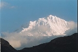
Kabru
Encyclopedia
Kabru is a mountain
in the Himalayas
on the border of India
and eastern Nepal
. It is part of a ridge that extends south from Kangchenjunga
.
 The main features of this ridge are as follows (north to south):
To the south west of Kabru south, there is a 6400 m saddle and a 6682 m summit known as Rathong. To its south east is the 6600 m Kabru Dome.
In 2004, a group of Serbia
n climbers unsuccessfully attempted the mountain. A series of avalanches forced the group to give up their goal.
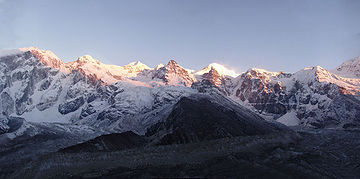
Mountain
Image:Himalaya_annotated.jpg|thumb|right|The Himalayan mountain range with Mount Everestrect 58 14 160 49 Chomo Lonzorect 200 28 335 52 Makalurect 378 24 566 45 Mount Everestrect 188 581 920 656 Tibetan Plateaurect 250 406 340 427 Rong River...
in the Himalayas
Himalayas
The Himalaya Range or Himalaya Mountains Sanskrit: Devanagari: हिमालय, literally "abode of snow"), usually called the Himalayas or Himalaya for short, is a mountain range in Asia, separating the Indian subcontinent from the Tibetan Plateau...
on the border of India
India
India , officially the Republic of India , is a country in South Asia. It is the seventh-largest country by geographical area, the second-most populous country with over 1.2 billion people, and the most populous democracy in the world...
and eastern Nepal
Nepal
Nepal , officially the Federal Democratic Republic of Nepal, is a landlocked sovereign state located in South Asia. It is located in the Himalayas and bordered to the north by the People's Republic of China, and to the south, east, and west by the Republic of India...
. It is part of a ridge that extends south from Kangchenjunga
Kangchenjunga
Kangchenjunga is the third highest mountain of the world with an elevation of and located along the India-Nepal border in the Himalayas.Kangchenjunga is also the name of the section of the Himalayas and means "The Five Treasures of Snows", as it contains five peaks, four of them over...
.
- Kangchenjunga south top, 8476 m, at 27°41′30"N 88°09′15"E
- A 6600–6700 m saddle, located at 27°39′51"N 88°09′39"E
- A 7349 m summit, known as Talung, at 27°39′18"N 88°07′51"E
- A 6983 m saddle, at 27°38′51"N 88°07′21"E
- A 7412 m summit, at 27°38′06"N 88°07′06"E. This point has sufficient prominenceTopographic prominenceIn topography, prominence, also known as autonomous height, relative height, shoulder drop , or prime factor , categorizes the height of the mountain's or hill's summit by the elevation between it and the lowest contour line encircling it and no higher summit...
to be classified as the highest point of a separate mountain, according to the definition used in List of highest mountains. It is confusingly referred to by some authorities as "Kabru IV", but it is not clear that this is correct, or that any "Kabru" name is correctly applied to this summit. According to the 1996 version of the Himalayan Journal (pp. 29–36), members of an Indian Army expedition reached this summit in May 1994. - A substantial "field of firn" measuring about 2 km from north to south, and 1 km from east to west. This is almost entirely over 7200 m, and the watershed divide that runs through this field does not drop below this height.
- A 7338 m summit, at 27°37′00"N 88°07′33"E, at the eastern boundary of the field of firn. This point, which is known as Kabru North, was reached by C.R.Cooke on 18 November 1935, without oxygen. It remained the highest solo climb until 1953. Although it is lower than the 7412 m summit, which Cooke did not ascend, it was considered at the time, and may still be considered, to be Kabru's highest point; the higher summit was considered to be an unnamed summit along the ridge to Kangchenjunga.
- An intervening c.7200 m saddle. Cooke's account implies that there are two intervening tops between this saddle and Kabru North.
- A 7318 m summit, at 27°36′30"N 88°06′42"E, known as Kabru South is the southernmost "7000 m peak" in the world. This was climbed by an Indian party in 1994.
To the south west of Kabru south, there is a 6400 m saddle and a 6682 m summit known as Rathong. To its south east is the 6600 m Kabru Dome.
In 2004, a group of Serbia
Serbia
Serbia , officially the Republic of Serbia , is a landlocked country located at the crossroads of Central and Southeast Europe, covering the southern part of the Carpathian basin and the central part of the Balkans...
n climbers unsuccessfully attempted the mountain. A series of avalanches forced the group to give up their goal.