

Joint Precision Approach and Landing System
Encyclopedia
The Joint Precision Approach and Landing System (JPALS) is a military, all-weather landing system based on real-time differential correction of the GPS
signal, augmented with a local area correction message, and transmitted to the user via secure means. The onboard receiver compares the current GPS-derived position with the local correction signal, deriving a highly accurate three-dimensional position capable of being used for all-weather approaches via an ILS
-style display. While JPALS is similar to Local Area Augmentation System
, but intended primarily for use by the military, some elements of JPALS may eventually see their way into civilian use to help protect high-value civilian operations against unauthorized signal alteration.
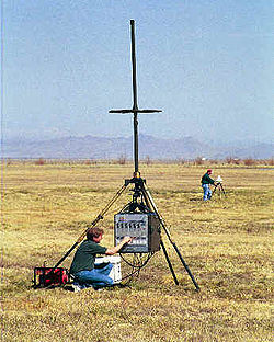 The development of JPALS was a result of two main military requirements. First, the military needs an all-service, highly mobile all-weather precision approach system, tailorable to a wide range of environments, from shipboard use to rapid installation at makeshift airfields. Second, they need a robust system that can maintain a high level of reliability in combat operations, particularly in its ability to effectively resist jamming.
LDGPS is further divided into three sub-categories: Fixed Base, Tactical, and Special Missions. Fixed Base is used for ongoing operations at military airfields around the world, while the Tactical system is portable, designed for relatively short-term, austere airfield operations. The Special Missions system is a highly portable system capable of rapid installation and use by Special Forces
.
, is better than CAT III ILS accuracy, and will provide horizontal and vertical resolutions of less than 1 m. Although the exact accuracy of JPALS will remain classified, it's estimated that JPALS will meet or exceed this accuracy for authorized users.
The naval version of JPALS transmits a signal that has a low probability of intercept. Therefore, it is unlikely that an enemy will detect the signal and trace it back to its source. The existing system, TACAN
, is not encrypted or concealed in any way, which can reveal the location of the ship on which it is installed. This is not acceptable in emissions control
(EMCON) or stealth conditions.
The increase in both accuracy and reliability will significantly enhance operations while reducing non-operational periods due to weather or adversarial efforts.
Global Positioning System
The Global Positioning System is a space-based global navigation satellite system that provides location and time information in all weather, anywhere on or near the Earth, where there is an unobstructed line of sight to four or more GPS satellites...
signal, augmented with a local area correction message, and transmitted to the user via secure means. The onboard receiver compares the current GPS-derived position with the local correction signal, deriving a highly accurate three-dimensional position capable of being used for all-weather approaches via an ILS
Instrument Landing System
An instrument landing system is a ground-based instrument approach system that provides precision guidance to an aircraft approaching and landing on a runway, using a combination of radio signals and, in many cases, high-intensity lighting arrays to enable a safe landing during instrument...
-style display. While JPALS is similar to Local Area Augmentation System
Local Area Augmentation System
The Local Area Augmentation System is an all-weather aircraft landing system based on real-time differential correction of the GPS signal. Local reference receivers located around the airport send data to a central location at the airport. This data is used to formulate a correction message, which...
, but intended primarily for use by the military, some elements of JPALS may eventually see their way into civilian use to help protect high-value civilian operations against unauthorized signal alteration.
History
Operation
JPALS encompasses two main categories: SRGPS and LDGPS. SRGPS provides highly accurate approach positioning for operations aboard ship, including aircraft carriers, helo and S/VTOL carriers, and other shipboard operations, primarily, but not limited to, helicopter operations.LDGPS is further divided into three sub-categories: Fixed Base, Tactical, and Special Missions. Fixed Base is used for ongoing operations at military airfields around the world, while the Tactical system is portable, designed for relatively short-term, austere airfield operations. The Special Missions system is a highly portable system capable of rapid installation and use by Special Forces
Special forces
Special forces, or special operations forces are terms used to describe elite military tactical teams trained to perform high-risk dangerous missions that conventional units cannot perform...
.
Accuracy
The accuracy of LAAS, or Local Area Augmentation SystemLocal Area Augmentation System
The Local Area Augmentation System is an all-weather aircraft landing system based on real-time differential correction of the GPS signal. Local reference receivers located around the airport send data to a central location at the airport. This data is used to formulate a correction message, which...
, is better than CAT III ILS accuracy, and will provide horizontal and vertical resolutions of less than 1 m. Although the exact accuracy of JPALS will remain classified, it's estimated that JPALS will meet or exceed this accuracy for authorized users.
Benefits
The main benefit of JPALS is that it's a system that can be taken anywhere, anytime, providing a safe and effective way to conduct 24/7, all-weather, anti-jam instrument landing system capability to all authorized users, worldwide. A secondary benefit is a significant reduction in cost over current systems.The naval version of JPALS transmits a signal that has a low probability of intercept. Therefore, it is unlikely that an enemy will detect the signal and trace it back to its source. The existing system, TACAN
Tactical Air Navigation
A tactical air navigation system, commonly referred to by the acronym TACAN, is a navigation system used by military aircraft. It provides the user with bearing and distance to a ground or ship-borne station. It is a more accurate version of the VOR/DME system that provides bearing and range...
, is not encrypted or concealed in any way, which can reveal the location of the ship on which it is installed. This is not acceptable in emissions control
EMCON
EMCON is a military condition in which electromagnetic emissions do not exceed a set limit. This helps to avoid electronic detection. The EMCON condition can be passed via an EMCON bill, directives, OP orders, message traffic or embarked or area commander.-External links:* ....
(EMCON) or stealth conditions.
The increase in both accuracy and reliability will significantly enhance operations while reducing non-operational periods due to weather or adversarial efforts.
See also
- Local Area Augmentation SystemLocal Area Augmentation SystemThe Local Area Augmentation System is an all-weather aircraft landing system based on real-time differential correction of the GPS signal. Local reference receivers located around the airport send data to a central location at the airport. This data is used to formulate a correction message, which...
is a similar system for civilian usage. - Wide Area Augmentation SystemWide Area Augmentation SystemThe Wide Area Augmentation System is an air navigation aid developed by the Federal Aviation Administration to augment the Global Positioning System , with the goal of improving its accuracy, integrity, and availability...
- Precision approach
- Instrument Landing SystemInstrument Landing SystemAn instrument landing system is a ground-based instrument approach system that provides precision guidance to an aircraft approaching and landing on a runway, using a combination of radio signals and, in many cases, high-intensity lighting arrays to enable a safe landing during instrument...
- Global Positioning SystemGlobal Positioning SystemThe Global Positioning System is a space-based global navigation satellite system that provides location and time information in all weather, anywhere on or near the Earth, where there is an unobstructed line of sight to four or more GPS satellites...
- Differential GPSDifferential GPSDifferential Global Positioning System is an enhancement to Global Positioning System that provides improved location accuracy, from the 15-meter nominal GPS accuracy to about 10 cm in case of the best implementations....