

Jermenovci
Encyclopedia
Village
A village is a clustered human settlement or community, larger than a hamlet with the population ranging from a few hundred to a few thousand , Though often located in rural areas, the term urban village is also applied to certain urban neighbourhoods, such as the West Village in Manhattan, New...
located in the Plandište
Plandište
Plandište is a village and municipality in South Banat District of Vojvodina, Serbia. The village has a population of 4,248, while Plandište municipality has 13,355 inhabitants...
municipality
Municipality
A municipality is essentially an urban administrative division having corporate status and usually powers of self-government. It can also be used to mean the governing body of a municipality. A municipality is a general-purpose administrative subdivision, as opposed to a special-purpose district...
, in the South Banat District
South Banat District
South Banat District is a northeastern district of Serbia with the seat of the district in Pančevo. It borders Romania to the east. The district lies in the region of Banat, in the autonomous province of Vojvodina...
of Serbia
Serbia
Serbia , officially the Republic of Serbia , is a landlocked country located at the crossroads of Central and Southeast Europe, covering the southern part of the Carpathian basin and the central part of the Balkans...
. It is situated in the Autonomous Province of Vojvodina
Vojvodina
Vojvodina, officially called Autonomous Province of Vojvodina is an autonomous province of Serbia. Its capital and largest city is Novi Sad...
. The village has a Hungarian ethnic majority.
History
At the time of its foundation in 1817, the village and the entire Bánát district territory ( named Banatski under Serbia since 1921 ) were part of the Hungarian Kingdom incorporated within the Austrian Empire, the governing rulers. Ürményháza was linked to the administrative county of Torontál (vármegye or county) in South Bánát district (Dél Bánsági Körzet). Draining of the marshlands prior to first human settlement necessitated the opening of the Maria Theresa Canal to bypass the future village of Ürményháza. In 1955, due to agricultural necessity to control recurrent flooding, this canal was widened and deepened to provide better drainage. With that improvement, the flow of water changed direction running from West to East. This important canal also changed its name to DTD Canal (Duna-Tisza-Duna-csatorna) and became a sector of this major waterway.The first settlers of Ürményháza were the handpicked 62 Roman Catholic Hungarian families that formed the nucleus population in 1817. These families had arrived from Majsa, Apátfalva, and Rákospuszta. 60 families received titled deeds for arable land and dwelling whereas 2 received deeds for housing land only. The original freehold title holders were primarily engaged in agriculture, animal husbandry and in growing of tobacco plant.
In 1856 the patriot from the War of Independence 1848-49, nevertheless infamous outlaw, rural bandit gang leader, the much feared but also loved by dirt poor peasantry Sándor Rózsa (betyár Rózsa Sándor < Hungarian version of Robin Hood>) who entered Hungarian national folklore, robbed with his gang the post office & national savings bank agency in Ürményháza. He escaped from the siege set by the gendarmes (csendõrs), but killed the local headborough/village judge, his very last mortal victim.
In 1867 the village in Southern Bánát, becomes part of the new Austro-Hungarian Empire. With the collapse of that Empire in 1918 followed by the Treaty of Trianon signed at Versailles on June 4, 1920, Bánát province territory (becoming Banatski) is ceded to the Serbian-Croatian-Slovenian Kingdom with the village changing its name or official appellation in 1921 to the new Serbian version name “Jermenovci”. In 1952 geologic surveys located crude oil in the vicinity. A large scale crude oil extraction industry is yet to be developed. The village is called Ürményháza by all Hungarians.As national statistics would attest, the population has grown greatly despite emigration to faraway lands but remained a predominantly ethnic Hungarian (Magyar) enclave to this date with its bilingual village folk holding Republic of Serbia citizenship. Jermenovci - Ürményháza is within South Banat District, one of the seven constituent provinces of the autonomous region of Voyvodina in the Republic of Serbia.
The name and its origin
Built on ingeniously dried and reclaimed vacant State property marshlands, the village was named “ Ürményháza” in 1817, in deference to its virtual founding father the nobleman and Crown Counsellor Ferenc Ürményi, the visionary public servant, the director of the Treasury’s Crown Lands Department in Temesvár, Transylvania ( Timisoara in today’s Romania).The original Hungarian " Ürményháza " name was changed to Jermenovci in 1921, following political alignment and cession of Bánát (Banatski since that date) to Serbia. Ürményháza had no connection with Armenians regardless of linguistic connotation that may exist in Serbian or German languages. The word "Örmény" means "Armenian" in Hungarian language, not the word " Ürmény" . In addition to being the village name, in Hungarian, Ürményháza means: “House of the Ürmény”, and Ürményi literally means: from Ürmény. Ürményháza or Ürményházi < both with upper case: Ü> are proper nouns, proper names whereas if written with the < lower case: ü > it is strictly the qualifying adjective indicating (from or of) Ürményháza as the village. However, in correct grammar, if the qualifying adjective is the very first word of a sentence, or of a caption, or of a local association's title then it must be shown in the upper case (like Ü, not ü).
Geography
The closest bigger places are PlandištePlandište
Plandište is a village and municipality in South Banat District of Vojvodina, Serbia. The village has a population of 4,248, while Plandište municipality has 13,355 inhabitants...
(8 km), Vršac
Vršac
Vršac is a town and municipality located in Serbia. In 2002 the town's total population was 36,623, while Vršac municipality had 54,369 inhabitants. Vršac is located in the Banat region, in the Vojvodina province of Serbia. It is part of the South Banat District.-Name:The name Vršac is of Serbian...
(21 km).
The village is 62 km North East from the capital, Belgrade
Belgrade
Belgrade is the capital and largest city of Serbia. It is located at the confluence of the Sava and Danube rivers, where the Pannonian Plain meets the Balkans. According to official results of Census 2011, the city has a population of 1,639,121. It is one of the 15 largest cities in Europe...
.
The Latitude
Latitude
In geography, the latitude of a location on the Earth is the angular distance of that location south or north of the Equator. The latitude is an angle, and is usually measured in degrees . The equator has a latitude of 0°, the North pole has a latitude of 90° north , and the South pole has a...
of the village is: N
North
North is a noun, adjective, or adverb indicating direction or geography.North is one of the four cardinal directions or compass points. It is the opposite of south and is perpendicular to east and west.By convention, the top side of a map is north....
45° 11' 18.24", and the Longitude
Longitude
Longitude is a geographic coordinate that specifies the east-west position of a point on the Earth's surface. It is an angular measurement, usually expressed in degrees, minutes and seconds, and denoted by the Greek letter lambda ....
is: E
East
East is a noun, adjective, or adverb indicating direction or geography.East is one of the four cardinal directions or compass points. It is the opposite of west and is perpendicular to north and south.By convention, the right side of a map is east....
21° 02' 22.40".
The village altitude
Altitude
Altitude or height is defined based on the context in which it is used . As a general definition, altitude is a distance measurement, usually in the vertical or "up" direction, between a reference datum and a point or object. The reference datum also often varies according to the context...
is at 75 metres.
Social Activities
Five associations cultivate and maintain strongly the Hungarian social and cultural heritage through the Ürményházi Ifjúsági Klub (Youth club) , the Polgárok Társulása (Citizens fellowship), the Ürményházi Hagyományápoló Kör (Heritage care circle), the Ürményházi Petőfi Sándor Művelődési Egyesület (Petőfi Sándor cultural association) and the Pipacs Nőegylet (Red Poppy Lady Embroiderers Club).The village is part of the Roman Catholic Communities Network (Katolikus Közösségek Hálozata)
of South Banat, and thus partake occasionally in social gettogethers of the districts involved
within the province. The village has robust ties in every field with Hungarian organisations in Vojvodina (Vajdaság), with Hungary and with pre-Trianon Hungarian communities outside Hungary through the bond of language, root culture, common heritage and ethnicity.
Notable Places and Activities
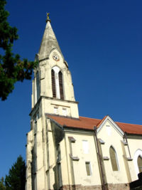
- R.C. Church of Szent Anna ( Church of St.Ann, Blessed Mother of the Virgin Mary ), Boldog Szűz Mária Édesanyja Szent Anna katolikus templom. Built in 1834-35, this church burned down but was reconstructed and reconsecrated in 1854.
- Mineral springs, confirmed therapeutic thermal and radio-active underground mud pools discovered in the area in 1973 yet to be developed
- Marginal crude oil industry visible through extraction pumps in the countryside
- Good fishing in the Duna-Tisza-Duna canal (D-T-D-csatorna)
Major Ethnic Groups
| Year | Total | Hungarians | Serbs Serbs The Serbs are a South Slavic ethnic group of the Balkans and southern Central Europe. Serbs are located mainly in Serbia, Montenegro and Bosnia and Herzegovina, and form a sizable minority in Croatia, the Republic of Macedonia and Slovenia. Likewise, Serbs are an officially recognized minority in... | Slovaks Slovaks The Slovaks, Slovak people, or Slovakians are a West Slavic people that primarily inhabit Slovakia and speak the Slovak language, which is closely related to the Czech language.Most Slovaks today live within the borders of the independent Slovakia... | Yugoslavs Yugoslavs Yugoslavs is a national designation used by a minority of South Slavs across the countries of the former Yugoslavia and in the diaspora... | Romanians Romanians The Romanians are an ethnic group native to Romania, who speak Romanian; they are the majority inhabitants of Romania.... | Roma | Undecided | Unknown |
| 1991 | 1,158 | 75.21% | 7.25% | 5.09% | 3.28% | 2.07% | 1.72% | >0,10% | 2.15% |
| 2002 | 1,033 | 69.11% | 10.93% | 6.19% | 1.93% | 1.83% | 1.64% | 4.54% | 2.03% |
Population Records
- 1961: 1,792
- 1971: 1,672
- 1981: 1,454
- 1991: 1,158
- 2002: 1,033
- 2010: 1,454
See also
- List of places in Serbia
- List of cities, towns and villages in Vojvodina