
Jeanville
Encyclopedia
Townland
A townland or bally is a small geographical division of land used in Ireland. The townland system is of Gaelic origin—most townlands are believed to pre-date the Norman invasion and most have names derived from the Irish language...
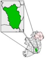
of Powerstown in the Barony of Gowran
Gowran
Gowran is a village and former town in County Kilkenny, Ireland. Gowran Park race course is located nearby. Gowran is located on the N9 national primary road where it is crossed by the R702 regional road.-History:...
near Goresbridge
Goresbridge
Goresbridge is a village on the R702 regional road in east County Kilkenny, Ireland, on the River Barrow.-History:Goresbridge is named for the New Bridge built in 1756 by Colonel Ralph Gore the first and last Earl of Ross. The bridge remains of significant importance in the area for its...
, County Kilkenny
County Kilkenny
County Kilkenny is a county in Ireland. It is part of the South-East Region and is also located in the province of Leinster. It is named after the city of Kilkenny. The territory of the county was the core part of the ancient Irish Kingdom of Osraige which in turn was the core of the Diocese of...
. Nearby is the village of Goresbridge
Goresbridge
Goresbridge is a village on the R702 regional road in east County Kilkenny, Ireland, on the River Barrow.-History:Goresbridge is named for the New Bridge built in 1756 by Colonel Ralph Gore the first and last Earl of Ross. The bridge remains of significant importance in the area for its...
and country estate of Mount Loftus
Mount Loftus
A country estate in Powerstown in County Kilkenny, Ireland. Originally home to the Loftus Baronets the baronetcy being extinct since the death of the third Baronet in 1864. A splendid set of entrance gates by William Turner of Stephen's Green can be seen on approach to the house....
.
History
Huguenot
The Huguenots were members of the Protestant Reformed Church of France during the 16th and 17th centuries. Since the 17th century, people who formerly would have been called Huguenots have instead simply been called French Protestants, a title suggested by their German co-religionists, the...
s in the area. Johnville House still exists today but does not use the earlier name.
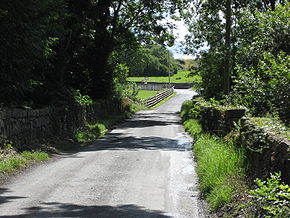
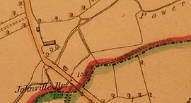
Johnville Bridge
The bridge still retains the original name of Johnville Bridge on all Ordnance Survey IrelandOrdnance Survey Ireland
Ordnance Survey Ireland is the national mapping agency of the Republic of Ireland and, together with the Ordnance Survey of Northern Ireland , succeeded, after 1922, the Irish operations of the United Kingdom Ordnance Survey. It is part of the Public service of the Republic of Ireland...
maps but is also unusual in design. This is because in close proximity to the Powerstown River, a branch tributary
Tributary
A tributary or affluent is a stream or river that flows into a main stem river or a lake. A tributary does not flow directly into a sea or ocean...
diverts water from the main stream closer to Johnville House before reconnecting with the Powerstown River. So the bridge is actually a set of two; one double arched bridge over the Powerstown River, and a single arched bridge over the tributary stream with the roadway being raised above the ground but still walled in on both sides. On the up-river side of the tributary there is a water filled depression known as the "Watering Hole" where a seasonal river joins on to the divert before flowing under the single arch section.