

Islandmagee
Encyclopedia
Peninsula
A peninsula is a piece of land that is bordered by water on three sides but connected to mainland. In many Germanic and Celtic languages and also in Baltic, Slavic and Hungarian, peninsulas are called "half-islands"....
on the east coast of County Antrim
County Antrim
County Antrim is one of six counties that form Northern Ireland, situated in the north-east of the island of Ireland. Adjoined to the north-east shore of Lough Neagh, the county covers an area of 2,844 km², with a population of approximately 616,000...
, Northern Ireland
Northern Ireland
Northern Ireland is one of the four countries of the United Kingdom. Situated in the north-east of the island of Ireland, it shares a border with the Republic of Ireland to the south and west...
, located between the towns of Larne
Larne
Larne is a substantial seaport and industrial market town on the east coast of County Antrim, Northern Ireland with a population of 18,228 people in the 2001 Census. As of 2011, there are about 31,000 residents in the greater Larne area. It has been used as a seaport for over 1,000 years, and is...
and Carrickfergus
Carrickfergus
Carrickfergus , known locally and colloquially as "Carrick", is a large town in County Antrim, Northern Ireland. It is located on the north shore of Belfast Lough, from Belfast. The town had a population of 27,201 at the 2001 Census and takes its name from Fergus Mór mac Eirc, the 6th century king...
. It is part of the Larne Borough Council
Larne Borough Council
Larne Borough Council is a Local Council in County Antrim in Northern Ireland. Its headquarters is in the town of Larne and the population of the area is nearly 31,000...
area and is a sparsely populated rural community with a long history since the mesolithic
Mesolithic
The Mesolithic is an archaeological concept used to refer to certain groups of archaeological cultures defined as falling between the Paleolithic and the Neolithic....
period.
As part of an agricultural crop rotation
Crop rotation
Crop rotation is the practice of growing a series of dissimilar types of crops in the same area in sequential seasons.Crop rotation confers various benefits to the soil. A traditional element of crop rotation is the replenishment of nitrogen through the use of green manure in sequence with cereals...
programme of old beans were grown to supply nitrogen to the soil. "Bean Eaters" became a nickname for the people of Islandmagee.
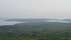
It is the site of Northern Ireland's main power station Ballylumford
Ballylumford power station
Ballylumford power station is a natural gas-fired power station in County Antrim, Northern Ireland. With its main plant generating 600 megawatts of electricity, it is Northern Ireland's largest power station and provides half of the country's power. Overall the station produces 1316MW...
.
History
The Bissett familyBissett family (Ireland)
The history of the Bissett family in Ireland can be studied independently from that of the originally identical family in Scotland, because of their unique experience following their arrival in Ulster in the early or mid-13th century...
held the tenancy of the peninsula in Elizabeth I's reign, their rent being an annual offering of goshawks, birds which bred on the rugged white chalk cliffs nearby.
Archaeology
- Islandmagee is the home of the Ballylumford DolmenBallylumford DolmenBallylumford Dolmen is situated on Islandmagee, County Antrim, Northern Ireland, near the north-west tip of the Islandmagee peninsula and near Ballylumford power station. It is known locally as the "Druid's Altar", and could be 4000 years old, or the remains of an even earlier passage grave...
. Known locally as the "Druid's Altar", this dolmen could be 4000 years old, or could be the remains of an even earlier passage grave. The dolmen consists of four upright stones, with a heavy capstone and a fallenstone within the structure. This may have been put there to block the entrance to the tomb. - NeolithicNeolithicThe Neolithic Age, Era, or Period, or New Stone Age, was a period in the development of human technology, beginning about 9500 BC in some parts of the Middle East, and later in other parts of the world. It is traditionally considered as the last part of the Stone Age...
houses have been excavated at BallyharryBallyharryBallyharry is an area of archaeological sites on Islandmagee, in County Antrim, Northern Ireland, where a number of well preserved Neolithic house sites have been investigated.-1996 and 2003 Investigations:...
, on the Islandmagee peninsula. Finds included Neolithic pottery, flint arrowheads, javelin heads, polished stone axe fragments and quernstonesQuern-stoneQuern-stones are stone tools for hand grinding a wide variety of materials. They were used in pairs. The lower, stationary, stone is called a quern, whilst the upper, mobile, stone is called a handstone...
.
Settlements and townlands
The peninsula is part of the parishCivil parish
In England, a civil parish is a territorial designation and, where they are found, the lowest tier of local government below districts and counties...
of Islandmagee. The boundaries of the parish and the peninsula match. Like the rest of Ireland, this parish is split into a number of townlands (bailte fearainn), whose names are derived from the Irish language
Irish language
Irish , also known as Irish Gaelic, is a Goidelic language of the Indo-European language family, originating in Ireland and historically spoken by the Irish people. Irish is now spoken as a first language by a minority of Irish people, as well as being a second language of a larger proportion of...
. There are 25 townlands on Islandmagee and two small settlements.
The following is a list of these townlands, with the settlements bolded:
- Ballylumford
- BallystrudderBallystrudderBallystrudder or Ballystruder is a small village and townland on Islandmagee in County Antrim, Northern Ireland. In the 2001 Census it had a population of 781 people. It is within the Larne Borough Council area.- 2001 Census :...
- Balloo
- Ballycronan Beg
- Ballycronan More
- Ballydown
- Ballyharry
- Ballykeel
- Ballymoney
- Ballymuldrogh
- Ballyprior Beg
- Ballyprior More
- Ballytober
- Carnspindle
- Castletown
- Cloghfin
- Drumgurland
- Dundressan
- Gransha
- Kilcoan Beg
- Kilcoan More
- MullaghboyMullaghboyMullaghboy is a small village and townland on Islandmagee in County Antrim, Northern Ireland. In the 2001 Census it had a population of 294. It is within the Larne Borough Council area.- References :*...
- Mullaghdoo
- Portmuck
- Temple-effin
Sport
- Islandmagee F.C. plays in the Northern Amateur Football LeagueNorthern Amateur Football LeagueThe Northern Amateur Football League, also known as the Northern Amateur League and often simply as the Amateur League, is an association football league in Northern Ireland. It contains 13 divisions...
Premier Division. - Two golf clubs, Whitehead Golf Club (18 holes) and Larne Golf Club (9 holes) lie on the peninsula, as do two horseriding centres - Rainbow Equestrian Centre and Islandmagee Riding Centre.
- Fishing continues to be the most common sport practiced in the region.