
Iowa Highway 26
Encyclopedia
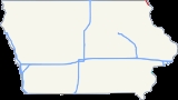
Iowa Highway 26 is a 11 miles (17.7 km) long state highway that runs from south to north in Allamakee County, Iowa
. It begins in Lansing
at an intersection with Iowa Highway 9 at the Black Hawk Bridge
and ends at the Minnesota border at New Albin
. It continues into Minnesota as Minnesota State Highway 26
(TH 26). Iowa 26 was created in 1969 in a numbering swap with Iowa Highway 182
. The designation was changed to match TH 26. The highway is the northernmost leg of the Great River Road
in Iowa. Most of the highway is designated the Driftless Area Scenic Byway.
 Iowa 26 begins at a T-intersection with Iowa 9 at the foot of the Black Hawk Bridge
in Lansing
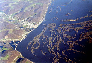
. As a part of the Drifless Area Scenic Byway and Great River Road, it heads north nestled between the bluffs that tower 300 feet (91.4 m) over the city and homes that line the Mississippi riverfront
. After exiting Lansing, the highway draws closer to the river and to the Dakota, Minnesota & Eastern Railroad.
The highway is dotted with houses as it continues north between the river and the bluffs. The bluffs were created during the last ice age
when this region of the midwest
was untouched by glaciers. The region is thus called the Driftless Area, referring to the lack of glacial drift
, the material left behind by retreating continental glaciers.
One-and-a-half miles (2.4 km) south of New Albin
, Iowa 26 crosses the Upper Iowa River
and then intersects County Road A26, which takes the Driftless Area Scenic Byway west to Iowa 76
. Through New Albin, it travels along Railroad Street, referring to the adjacent railroad. Heading northeast, it leaves the city, which is also the state line, crossing into Minnesota
as Trunk Highway 26
.
to Primary Road No. 19 in northwestern Iowa.
The second Iowa 26 was created in the 1930s and served as a connector between U.S. Route 18 at Inwood
and Iowa 9 south of Larchwood
. In 1969, the second iteration of Iowa 26 swapped designations with Iowa 182, as to match Minnesota's Trunk Highway 26.
Allamakee County, Iowa
-2010 census:The 2010 census recorded a population of 14,330 in the county, with a population density of . There were 7,617 housing units, of which 5,845 were occupied.-2000 census:...
. It begins in Lansing
Lansing, Iowa
Lansing is a city in Lansing Township, Allamakee County, Iowa, United States. The population was 1,012 at the 2000 census.-Geography:Lansing's longitude and latitude coordinatesin decimal form are 43.361525, -91.223378...
at an intersection with Iowa Highway 9 at the Black Hawk Bridge
Black Hawk Bridge
The Black Hawk Bridge spans the Mississippi River, joining the town of Lansing, in Allamakee County, Iowa, to rural Crawford County, Wisconsin. It is the northernmost Mississippi River bridge in Iowa....
and ends at the Minnesota border at New Albin
New Albin, Iowa
New Albin is a city in Iowa Township, Allamakee County, Iowa, United States. It is the farthest northeast town in Iowa, located on the Mississippi River and the Minnesota border...
. It continues into Minnesota as Minnesota State Highway 26
Minnesota State Highway 26
Minnesota State Highway 26 is a state highway in southeastern corner of the U.S. state of Minnesota. At in length, Highway 26 runs parallel to the Mississippi River and is a portion of the Great River Road...
(TH 26). Iowa 26 was created in 1969 in a numbering swap with Iowa Highway 182
Iowa Highway 182
Iowa Highway 182 is a long state highway in the northwestern corner of Iowa. It begins at U.S. Route 18 in Inwood and ends at Iowa Highway 9 southeast of Larchwood. The route swapped designations with Iowa Highway 26 in 1969.-Route description:...
. The designation was changed to match TH 26. The highway is the northernmost leg of the Great River Road
Great River Road
The Great River Road is a collection of state, provincial, federal, and local roads which follow the course of the Mississippi River through ten states of the United States...
in Iowa. Most of the highway is designated the Driftless Area Scenic Byway.
Route description
Black Hawk Bridge
The Black Hawk Bridge spans the Mississippi River, joining the town of Lansing, in Allamakee County, Iowa, to rural Crawford County, Wisconsin. It is the northernmost Mississippi River bridge in Iowa....
in Lansing
Lansing, Iowa
Lansing is a city in Lansing Township, Allamakee County, Iowa, United States. The population was 1,012 at the 2000 census.-Geography:Lansing's longitude and latitude coordinatesin decimal form are 43.361525, -91.223378...
. As a part of the Drifless Area Scenic Byway and Great River Road, it heads north nestled between the bluffs that tower 300 feet (91.4 m) over the city and homes that line the Mississippi riverfront
Mississippi River
The Mississippi River is the largest river system in North America. Flowing entirely in the United States, this river rises in western Minnesota and meanders slowly southwards for to the Mississippi River Delta at the Gulf of Mexico. With its many tributaries, the Mississippi's watershed drains...
. After exiting Lansing, the highway draws closer to the river and to the Dakota, Minnesota & Eastern Railroad.
The highway is dotted with houses as it continues north between the river and the bluffs. The bluffs were created during the last ice age
Ice age
An ice age or, more precisely, glacial age, is a generic geological period of long-term reduction in the temperature of the Earth's surface and atmosphere, resulting in the presence or expansion of continental ice sheets, polar ice sheets and alpine glaciers...
when this region of the midwest
Midwestern United States
The Midwestern United States is one of the four U.S. geographic regions defined by the United States Census Bureau, providing an official definition of the American Midwest....
was untouched by glaciers. The region is thus called the Driftless Area, referring to the lack of glacial drift
Drift (geology)
In geology, drift is the name for all material of glacial origin found anywhere on land or at sea , including sediment and large rocks...
, the material left behind by retreating continental glaciers.
One-and-a-half miles (2.4 km) south of New Albin
New Albin, Iowa
New Albin is a city in Iowa Township, Allamakee County, Iowa, United States. It is the farthest northeast town in Iowa, located on the Mississippi River and the Minnesota border...
, Iowa 26 crosses the Upper Iowa River
Upper Iowa River
The Upper Iowa River is a tributary of the Mississippi River in the upper Midwest of the United States.Its headwaters are in southeastern Minnesota, in Mower County near the border with Iowa. It then flows through the Iowa counties of Howard, Winneshiek, and Allamakee, and finally into the Upper...
and then intersects County Road A26, which takes the Driftless Area Scenic Byway west to Iowa 76
Iowa Highway 76
Iowa Highway 76 is a state highway located in northeastern Iowa, most of which is in Allamakee County. The long highway connects McGregor to Eitzen, Minnesota via Waukon. It begins in McGregor at an intersection with U.S. Route 18; the first of the route are signed as U.S. Route 18 Business...
. Through New Albin, it travels along Railroad Street, referring to the adjacent railroad. Heading northeast, it leaves the city, which is also the state line, crossing into Minnesota
Minnesota
Minnesota is a U.S. state located in the Midwestern United States. The twelfth largest state of the U.S., it is the twenty-first most populous, with 5.3 million residents. Minnesota was carved out of the eastern half of the Minnesota Territory and admitted to the Union as the thirty-second state...
as Trunk Highway 26
Minnesota State Highway 26
Minnesota State Highway 26 is a state highway in southeastern corner of the U.S. state of Minnesota. At in length, Highway 26 runs parallel to the Mississippi River and is a portion of the Great River Road...
.
History
Prior to its current designation in 1969, there were two iterations of Iowa Highway 26. The first, Primary Road No. 26, was a short, 3 miles (4.8 km) long highway which, in the 1920s, connected Rock ValleyRock Valley, Iowa
Rock Valley is a city in Sioux County, Iowa, United States, along the Rock River. The population was 2,702 at the 2000 census.-Geography:Rock Valley is located at ....
to Primary Road No. 19 in northwestern Iowa.
The second Iowa 26 was created in the 1930s and served as a connector between U.S. Route 18 at Inwood
Inwood, Iowa
Inwood is a city in Lyon County, Iowa, United States. The population was 875 at the 2000 census.-Geography:Inwood's longitude and latitude coordinatesin decimal form are 43.308770, -96.432531...
and Iowa 9 south of Larchwood
Larchwood, Iowa
Larchwood is a city in Lyon County, Iowa, United States. The population was 788 at the 2000 census. Its main employer is the Novartis Animal Vaccines plant located southwest of the city.-History:...
. In 1969, the second iteration of Iowa 26 swapped designations with Iowa 182, as to match Minnesota's Trunk Highway 26.