
Interstate 29 in Missouri
Encyclopedia
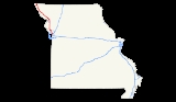
Interstate 29
, a major north–south Interstate Highway in the Midwestern United States, begins in Missouri
. It travels through the Kansas City and St. Joseph metropolitan areas before exiting the state and entering Iowa
. Almost all of I-29 in Missouri lies in an area called the Platte Purchase
that was not originally part of Missouri when it entered the union.
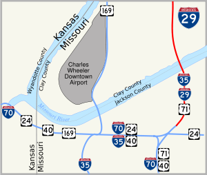 Interstate 29 begins at Interstate 70 in Kansas City in a concurrency with Interstate 35 and U.S. Route 71. It crosses over the Missouri River
via the Bond Bridge. I-29 and I-35 separate in northern Kansas City, with I-29 turning northwest with US 71 running concurrent with it. It passes near Kansas City International Airport
, and near there is concurrent with Interstate 435. I-29 then exits the Kansas City area. It enters the eastern portion of St. Joseph while downtown St. Joseph is served by I-229
, a loop of I-29. After exiting St. Joseph, US 71 separates from I-29. Interstate 29 then passes through rural areas of northwestern Missouri on a southeast-to-northwest alignment, then crosses into Iowa
north of Rock Port
.
Interstate 29
Interstate 29 is an Interstate Highway in the Midwestern United States. I-29 runs from Kansas City, Missouri, at a junction with Interstate 35 and Interstate 70 to the Canadian border near Pembina, North Dakota, where it connects with Manitoba Highway 75 via the short Manitoba Highway 29.-Route...
, a major north–south Interstate Highway in the Midwestern United States, begins in Missouri
Missouri
Missouri is a US state located in the Midwestern United States, bordered by Iowa, Illinois, Kentucky, Tennessee, Arkansas, Oklahoma, Kansas and Nebraska. With a 2010 population of 5,988,927, Missouri is the 18th most populous state in the nation and the fifth most populous in the Midwest. It...
. It travels through the Kansas City and St. Joseph metropolitan areas before exiting the state and entering Iowa
Iowa
Iowa is a state located in the Midwestern United States, an area often referred to as the "American Heartland". It derives its name from the Ioway people, one of the many American Indian tribes that occupied the state at the time of European exploration. Iowa was a part of the French colony of New...
. Almost all of I-29 in Missouri lies in an area called the Platte Purchase
Platte Purchase
The Platte Purchase was a land acquisition in 1836 by the United States government from Native American tribes all of which was east bank lands along the Missouri River that added to the northwest corner of the state of Missouri. The area acquired is almost as large as the states of Delaware and...
that was not originally part of Missouri when it entered the union.
Route description
Missouri River
The Missouri River flows through the central United States, and is a tributary of the Mississippi River. It is the longest river in North America and drains the third largest area, though only the thirteenth largest by discharge. The Missouri's watershed encompasses most of the American Great...
via the Bond Bridge. I-29 and I-35 separate in northern Kansas City, with I-29 turning northwest with US 71 running concurrent with it. It passes near Kansas City International Airport
Kansas City International Airport
Kansas City International Airport , originally named Mid-Continent International Airport, is a public airport located 15 miles northwest of the central business district of Kansas City, in Platte County, Missouri, United States. In 2008, 10,469,892 passengers used the airport...
, and near there is concurrent with Interstate 435. I-29 then exits the Kansas City area. It enters the eastern portion of St. Joseph while downtown St. Joseph is served by I-229
Interstate 229 (Missouri)
Interstate 229 in the state of Missouri, USA, is an approximately 14 mile Interstate Highway spur designed to speed traffic from Interstate 29 to downtown Saint Joseph....
, a loop of I-29. After exiting St. Joseph, US 71 separates from I-29. Interstate 29 then passes through rural areas of northwestern Missouri on a southeast-to-northwest alignment, then crosses into Iowa
Iowa
Iowa is a state located in the Midwestern United States, an area often referred to as the "American Heartland". It derives its name from the Ioway people, one of the many American Indian tribes that occupied the state at the time of European exploration. Iowa was a part of the French colony of New...
north of Rock Port
Rock Port, Missouri
Rock Port is a city in Clay Township, Atchison County, Missouri, United States and the county seat of Atchison County. The population was 1,318 at the 2010 census...
.
Exit list
| County | Location | # Exit number An exit number is a number assigned to a road junction, usually an exit from a freeway. It is usually marked on the same sign as the destinations of the exit, as well as a sign in the gore.... |
Destinations | Notes |
|---|---|---|---|---|
| Jackson | Kansas City | Southbound exit and northbound entrance | ||
| 3 | Southbound exit and northbound entrance | |||
| 4A | Southbound exit and northbound entrance | |||
| 4B | Front Street | |||
| Bond Bridge over the Missouri River Missouri River The Missouri River flows through the central United States, and is a tributary of the Mississippi River. It is the longest river in North America and drains the third largest area, though only the thirteenth largest by discharge. The Missouri's watershed encompasses most of the American Great... |
||||
| Clay | North Kansas City | |||
| 5A | Levee Road | Southbound exit and northbound entrance | ||
| 5A | Bedford Street | Northbound exit and southbound entrance | ||
| 5B | 16th Avenue | Northbound exit and southbound entrance | ||
| 6 | Signed as exits 6A (east) and 6B (west) | |||
| Kansas City | 8A | Parvin Road | ||
| North end of I-35 overlap | ||||
| 1B | – Des Moines | No exit number northbound | ||
| 1A | Davidson Road | |||
| 1CD | Signed as exits 1C (north) and 1D (south); no exit 1D northbound | |||
| 1E | ||||
| 2A | ||||
| 2B | Southbound exit and northbound entrance | |||
| Platte | 3A | Waukomis Drive | Northbound exit and southbound entrance | |
| 3C | Northwest Gateway Avenue | Southbound exit and northbound entrance | ||
| 3B | – Kansas Kansas Kansas is a US state located in the Midwestern United States. It is named after the Kansas River which flows through it, which in turn was named after the Kansa Native American tribe, which inhabited the area. The tribe's name is often said to mean "people of the wind" or "people of the south... |
|||
| 4 | Northwest 56th Street | Northbound exit and southbound entrance | ||
| 5 | ||||
| 6 | Northwest 72nd Street – Platte Woods Platte Woods, Missouri Platte Woods is a city in Platte County, Missouri, United States. The population was 474 at the 2000 census.-Geography:Platte Woods is located at .... |
|||
| Platte Woods | ||||
| Kansas City | 8 | |||
| 9 | – Topeka, Liberty | Signed as exits 9A (east) and 9B (west) | ||
| 10 | Tiffany Springs Parkway | |||
| 12 | Northwest 112th Street | |||
| 13 | ||||
| 14 | South end of I-435 overlap; northbound exit is via exit 13 | |||
| 15 | Mexico City Avenue | |||
| 17 | – Topeka | North end of I-435 overlap | ||
| Platte City | 18 | , Leavenworth, Smithville | ||
| 19 | ||||
| 20 | ||||
| 25 | ||||
| Dearborn | 30 | |||
| Buchanan | 35 | |||
| 43 | ||||
| St. Joseph | 44 | |||
| 46 | Signed as exits 46A (east) and 46B (west) | |||
| 47 | ||||
| 50 | ||||
| Andrew | 53 | South end of US 59 overlap | ||
| 56 | North end of US 59/US 71 overlap; signed as exits 56A (north) and 56B (south) | |||
| 60 | ||||
| 65 | South end of US 59 overlap | |||
| Holt | 67 | North end of US 59 overlap | ||
| 75 | ||||
| 79 | – Rulo | |||
| Mound City | 84 | |||
| 92 | ||||
| 99 | ||||
| Atchison | ||||
| 107 | ||||
| Rock Port Rock Port, Missouri Rock Port is a city in Clay Township, Atchison County, Missouri, United States and the county seat of Atchison County. The population was 1,318 at the 2010 census... |
110 | |||
| 116 | ||||