
Interstate 196
Encyclopedia
Interstate 196 is a long freeway spur route in the US state of Michigan
linking Grand Rapids
, Holland
, South Haven
, and Benton Harbor
. I-196 is known as the Gerald R. Ford
Freeway, or simply the Ford Freeway, in Kent
, Ottawa
, and Allegan
Counties, after the 38th President of the United States
, whose political career began in Grand Rapids. This name generally refers only to the section between Holland and Grand Rapids.
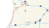
I-196 changes direction although it is a through route. It is a north–south route from its southern terminus to the junction with US 31 just south of Holland and an east–west route from this point to its eastern terminus. The total length is 80.65 miles (129.79 km).
 At first, Interstate 96 was planned to run from Detroit to Lansing
to Grand Rapids to Benton Harbor, and I-196 was to be a spur route from Grand Rapids to Muskegon
. However, I-96 from Detroit to Grand Rapids and I-196 from Grand Rapids to Muskegon was completed a few years before the segment from Grand Rapids to Benton Harbor. Thus it appeared as if I-196 were simply a continuation of I-96. Before the Grand Rapids-Benton Harbor segment was completed, the Michigan Department of Transportation
(MDOT) petitioned federal highway officials to switch the interstate designations west of Grand Rapids. Permission for this switch was granted in 1963. Consideration was also made to name the Grand Rapids-to-Benton Harbor freeway I-67, but was later withdrawn.
 The route begins by mile numbers just north of Benton Harbor
in Berrien County
. As it travels north it does the usual long haul road of a few bends to keep the drivers awake. Overall it bypasses the few cities that it comes across along the shore of Lake Michigan
. Before it reaches Ottawa County
the US 31 route gets removed at the partial interchange south of Holland. From there it travels on a northeast routing through Ottawa County bypassing the cities of Holland
, Zeeland
, and Hudsonville
by a wide margin. The only jog that goes fairly northerly is when it comes close to Chicago Drive on the east side of Zeeland. That is also when Business Loop I-196 begins. As it continues northeast it approaches M-6
. After crossing into Kent County
it straddles the east side part of the border with Ottawa County and goes north for a few miles until it hits Chicago Drive interchange. From there it travels again with a northeastern path until it crosses the Grand River
after being on its side from Chicago Drive. At this point it heads due north to the Lake Michigan Avenue/M-45
interchange. After a short northeast adjustment of the route it travels due east through downtown Grand Rapids and the Medical Corridor to its terminus with the partial interchange with Interstate 96.
. The first segment of freeway built was a relocated section of US 16 near Coopersville
and Marne
. The freeway opened at the end of 1957, and the first markers for I-196 were erected in 1960. The full Grand Rapids – Muskegon freeway was completed and opened to traffic in 1961. At this time, I-96 is planned to run from Grand Rapids south to Benton Harbor. In late 1963 the two designations were flipped west of Grand Rapids. The previously completed I-196 is redesignated as a part of I-96 and completed freeway segments south of Grand Rapids are redesignated as I-196.
was moved to the freeway from its previous surface-street routing.
The previous routing of M-21 was created as Business M-21 (BUS M-21) when M-21 was moved to the freeway. In 1972, this business loop was truncated in the middle, creating a business spur. East of US 131, BUS M-21 was turned back to local control and removed from the state highway system. The final link in the freeway was completed in 1973, completing I-196 for a second time. The Holland–Grandville segment was opened, and BUS M-21 was redesignated BS I-196 between Wyoming and Grand Rapids. The signs were removed from the segment of the business spur in Grandville, making it an unsigned highway. In 1974 through 1976, a business loop for Holland was created along Chicago Drive in Zeeland into downtown Holland. The signs were removed from Chicago Drive between Zeeland and Grandville, making that stretch of road another unsigned state highway.
The unsigned highways were slowly turned back to local control. In 1982, sections of Chicago Drive in Grandville were turned back with the remainder in 1985. In 2007, the remaining unsigned highway was redesignated M-121 (Michigan highway)
between BL I-196 in Zeeland and I-196 on the Jenison–Grandville border.
 The other study involves the stretch from US 131
to its connection with I-96. Among the recommendations are: a third lane from the I-96 interchange to US 131; a weave merge lane from Fuller Avenue to Division Avenue; new junctions from eastbound I-96 to westbound I-196, and from eastbound I-196 to westbound I-96; adjustments to exit ramps and local roads; and additional reconfiguration of the M-37
/M-44
(East Beltline) interchange area. According to MDOT in the planning part of the website the Federal Government found a Finding of No Significant Impact in December 2005. As such the department has decided that a 2010 start date will be used for this project.
Michigan
Michigan is a U.S. state located in the Great Lakes Region of the United States of America. The name Michigan is the French form of the Ojibwa word mishigamaa, meaning "large water" or "large lake"....
linking Grand Rapids
Grand Rapids, Michigan
Grand Rapids is a city in the U.S. state of Michigan. The city is located on the Grand River about 40 miles east of Lake Michigan. As of the 2010 census, the city population was 188,040. In 2010, the Grand Rapids metropolitan area had a population of 774,160 and a combined statistical area, Grand...
, Holland
Holland, Michigan
Holland is a city in the western region of the Lower Peninsula of the U.S. state of Michigan. It is situated near the eastern shore of Lake Michigan on Lake Macatawa, which is fed by the Macatawa River ....
, South Haven
South Haven, Michigan
South Haven is a city in the U.S. state of Michigan. Most of the city is in Van Buren County, although a small portion extends into Allegan County. The population was 5,021 at the 2000 census....
, and Benton Harbor
Benton Harbor, Michigan
Benton Harbor is a city in Berrien County in the U.S. state of Michigan which is located west of Kalamazoo. The population was 10,038 at the 2010 census. It is the lesser populated of the two principal cities included in the Niles-Benton Harbor, Michigan Metropolitan Statistical Area, which has a...
. I-196 is known as the Gerald R. Ford
Gerald Ford
Gerald Rudolph "Jerry" Ford, Jr. was the 38th President of the United States, serving from 1974 to 1977, and the 40th Vice President of the United States serving from 1973 to 1974...
Freeway, or simply the Ford Freeway, in Kent
Kent County, Michigan
-Air Service:*Commercial air service to Grand Rapids is provided by Gerald R. Ford International Airport . Previously named Kent County International Airport, it holds Grand Rapids' mark in modern history with the United States' first regularly scheduled airline service, beginning July 31, 1926,...
, Ottawa
Ottawa County, Michigan
-Demographics:As of the census of 2000, there were 238,314 people, 81,662 households, and 61,328 families residing in the county. The population density was 421 people per square mile . There were 86,856 housing units at an average density of 154 per square mile...
, and Allegan
Allegan County, Michigan
-Interstates:* I-196* I-196 Business Loop serves the city of Holland.-US highways:* US-31* US-131-Michigan State Trunklines:* M-40* M-89* M-179* M-222-Allegan County Intercounty Highways:* A-2* A-37* A-42* A-45-Demographics:...
Counties, after the 38th President of the United States
President of the United States
The President of the United States of America is the head of state and head of government of the United States. The president leads the executive branch of the federal government and is the commander-in-chief of the United States Armed Forces....
, whose political career began in Grand Rapids. This name generally refers only to the section between Holland and Grand Rapids.
I-196 changes direction although it is a through route. It is a north–south route from its southern terminus to the junction with US 31 just south of Holland and an east–west route from this point to its eastern terminus. The total length is 80.65 miles (129.79 km).
Lansing, Michigan
Lansing is the capital of the U.S. state of Michigan. It is located mostly in Ingham County, although small portions of the city extend into Eaton County. The 2010 Census places the city's population at 114,297, making it the fifth largest city in Michigan...
to Grand Rapids to Benton Harbor, and I-196 was to be a spur route from Grand Rapids to Muskegon
Muskegon, Michigan
Muskegon is a city in the U.S. state of Michigan. As of the 2010 census, the city population was 38,401. The city is the county seat of Muskegon County...
. However, I-96 from Detroit to Grand Rapids and I-196 from Grand Rapids to Muskegon was completed a few years before the segment from Grand Rapids to Benton Harbor. Thus it appeared as if I-196 were simply a continuation of I-96. Before the Grand Rapids-Benton Harbor segment was completed, the Michigan Department of Transportation
Michigan Department of Transportation
The Michigan Department of Transportation is a constitutional government agency in the US state of Michigan. The primary purpose of MDOT is to maintain the Michigan State Trunkline Highway System which includes all Interstate, US and state highways in Michigan with the exception of the Mackinac...
(MDOT) petitioned federal highway officials to switch the interstate designations west of Grand Rapids. Permission for this switch was granted in 1963. Consideration was also made to name the Grand Rapids-to-Benton Harbor freeway I-67, but was later withdrawn.
Route description
Benton Harbor, Michigan
Benton Harbor is a city in Berrien County in the U.S. state of Michigan which is located west of Kalamazoo. The population was 10,038 at the 2010 census. It is the lesser populated of the two principal cities included in the Niles-Benton Harbor, Michigan Metropolitan Statistical Area, which has a...
in Berrien County
Berrien County, Michigan
Berrien County is a county located in the extreme southwest of the U.S. state of Michigan. It is included in the Niles-Benton Harbor, Michigan Metropolitan Statistical Area. As of the 2010 census, the population was 156,813. The county seat is St. Joseph....
. As it travels north it does the usual long haul road of a few bends to keep the drivers awake. Overall it bypasses the few cities that it comes across along the shore of Lake Michigan
Lake Michigan
Lake Michigan is one of the five Great Lakes of North America and the only one located entirely within the United States. It is the second largest of the Great Lakes by volume and the third largest by surface area, after Lake Superior and Lake Huron...
. Before it reaches Ottawa County
Ottawa County, Michigan
-Demographics:As of the census of 2000, there were 238,314 people, 81,662 households, and 61,328 families residing in the county. The population density was 421 people per square mile . There were 86,856 housing units at an average density of 154 per square mile...
the US 31 route gets removed at the partial interchange south of Holland. From there it travels on a northeast routing through Ottawa County bypassing the cities of Holland
Holland, Michigan
Holland is a city in the western region of the Lower Peninsula of the U.S. state of Michigan. It is situated near the eastern shore of Lake Michigan on Lake Macatawa, which is fed by the Macatawa River ....
, Zeeland
Zeeland, Michigan
Zeeland is a city in Ottawa County in the U.S. state of Michigan. The population was 5,805 at the 2000 census. The city is located at the western edge of Zeeland Charter Township which is politically independent. Its name is derived from the Dutch province of Zeeland...
, and Hudsonville
Hudsonville, Michigan
Hudsonville is a city in Ottawa County in the U.S. state of Michigan. As of the 2000 census, the city population was 7,160.-Demographics:As of the census of 2000, there were 7,160 people, 2,514 households, and 1,920 families residing in the city. The population density was 1,729.1 per square mile...
by a wide margin. The only jog that goes fairly northerly is when it comes close to Chicago Drive on the east side of Zeeland. That is also when Business Loop I-196 begins. As it continues northeast it approaches M-6
M-6 (Michigan highway)
M-6, or the Paul B. Henry Freeway, is a freeway and state trunkline highway in the United States that serves portions of southern Kent and eastern Ottawa counties south of Grand Rapids, Michigan. Although the freeway is named for Paul B. Henry, local residents and the press continue to use the...
. After crossing into Kent County
Kent County, Michigan
-Air Service:*Commercial air service to Grand Rapids is provided by Gerald R. Ford International Airport . Previously named Kent County International Airport, it holds Grand Rapids' mark in modern history with the United States' first regularly scheduled airline service, beginning July 31, 1926,...
it straddles the east side part of the border with Ottawa County and goes north for a few miles until it hits Chicago Drive interchange. From there it travels again with a northeastern path until it crosses the Grand River
Grand River (Michigan)
The Grand River is the longest river in the U.S. state of Michigan. It runs through the cities of Jackson, Eaton Rapids, Lansing, Grand Rapids, and Grand Haven.-Description:...
after being on its side from Chicago Drive. At this point it heads due north to the Lake Michigan Avenue/M-45
M-45 (Michigan highway)
M-45 is a state trunkline highway in the US state of Michigan that is also called Lake Michigan Drive. The highway runs from Agnew near Lake Michigan to the west side of Grand Rapids in the western Lower Peninsula. Lake Michigan Drive continues in each direction from M-45's termini, extending west...
interchange. After a short northeast adjustment of the route it travels due east through downtown Grand Rapids and the Medical Corridor to its terminus with the partial interchange with Interstate 96.
Previous designation
The Interstate 196 designation was originally planned for a spur route from Grand Rapids to MuskegonMuskegon, Michigan
Muskegon is a city in the U.S. state of Michigan. As of the 2010 census, the city population was 38,401. The city is the county seat of Muskegon County...
. The first segment of freeway built was a relocated section of US 16 near Coopersville
Coopersville, Michigan
Coopersville is a city located in north central Ottawa County in the U.S. state of Michigan. The population was 4,275 at the 2010 census. It is primarily a farming community....
and Marne
Marne, Michigan
Marne is an unincorporated community in Wright Township of Ottawa County in the U.S. state of Michigan. Township offices are located in the community...
. The freeway opened at the end of 1957, and the first markers for I-196 were erected in 1960. The full Grand Rapids – Muskegon freeway was completed and opened to traffic in 1961. At this time, I-96 is planned to run from Grand Rapids south to Benton Harbor. In late 1963 the two designations were flipped west of Grand Rapids. The previously completed I-196 is redesignated as a part of I-96 and completed freeway segments south of Grand Rapids are redesignated as I-196.
Current designation
In late 1961, a section of freeway along US 31 was opened between I-94 and the Berrien – Van Buren county line. This section was originally designated as part of I-96/US 31. After the designation switch, additional freeway mileage is opened from the northern end of I-196 to Douglas, and from Saugatuck north to Holland as I-196/US 31. The bypass of Saugatuck–Douglas was opened the next year, linking the two sections of freeway. An additional section of freeway was opened between Grandville through downtown Grand Rapids to meet I-96 at the end of 1964. M-21M-21 (Michigan highway)
M-21 is an east–west state trunkline highway in the US state of Michigan connecting the cities of Grand Rapids and Flint. The highway passes through rural farming country and several small towns along its course through the Lower Peninsula...
was moved to the freeway from its previous surface-street routing.
The previous routing of M-21 was created as Business M-21 (BUS M-21) when M-21 was moved to the freeway. In 1972, this business loop was truncated in the middle, creating a business spur. East of US 131, BUS M-21 was turned back to local control and removed from the state highway system. The final link in the freeway was completed in 1973, completing I-196 for a second time. The Holland–Grandville segment was opened, and BUS M-21 was redesignated BS I-196 between Wyoming and Grand Rapids. The signs were removed from the segment of the business spur in Grandville, making it an unsigned highway. In 1974 through 1976, a business loop for Holland was created along Chicago Drive in Zeeland into downtown Holland. The signs were removed from Chicago Drive between Zeeland and Grandville, making that stretch of road another unsigned state highway.
The unsigned highways were slowly turned back to local control. In 1982, sections of Chicago Drive in Grandville were turned back with the remainder in 1985. In 2007, the remaining unsigned highway was redesignated M-121 (Michigan highway)
M-121 (Michigan highway)
M-121 is a state trunkline highway in West Michigan. The highway follows Chicago Drive, a local roadway, from Zeeland to Grandville. Chicago Drive itself runs past the M-121 segment on either from Holland to Wyoming. The roadway passes through rural farmland on a route that runs parallel to...
between BL I-196 in Zeeland and I-196 on the Jenison–Grandville border.
Future
MDOT currently has two studies underway to improve traffic flow. The first one is nearly completed and construction is planned for 2007-08. The end result of the study is a new exit planned for immediately before the Grandville/Jenison Chicago Drive exit. The exit is needed to alleviate traffic backups for motorists connecting via Chicago Drive to Baldwin Street, which involves crossing heavily-used CSX railroad tracks. The new exit puts traffic directly onto Baldwin Street, which would allow traffic to avoid crossing the grade level CSX railroad tracks. The start date for this project has been stated as spring of 2008 with a finish date of fall of 2009. According to the latest from MDOT the change will involve reconstructing Baldwin Ave with 5 lanes of traffic and adding a right turn lane to Main St. From Mill St to 196 the current Baldwin Ave will be replaced with a more east–west street. At the Grandville Waste Treatment plant more changes occur. This involves moving the current entrance to one that bridges over Rush Creek. This will allow for the ramps to be built properly and without traffic from the plant causing issues since the current plant entrance is located at the end of the future ramp. Another change will put a cul-de-sac at the end of Old M-21 before Rush Creek. As a result the bridge over the creek will be removed along with the intersection of it with Baldwin St. The only other change is at the intersection of Main St and Baldwin. This involves a new alignment of the intersection with property taken from the Jenison Baptist Temple. On 196 itself two new bridges will be built to take the onramp from Baldwin. Furthermore to accept the new weave merge lane from Chicago Dr to 28th Street two new bridges will be built over Buck Creek and the CSX railroad tracks.U.S. Route 131
US Highway 131 is a north–south United States Highway, of which all but 0.67 miles of its 266.82 miles are within the state of Michigan. The highway starts in rural Indiana south of the state line as a state road connection to the Indiana Toll Road...
to its connection with I-96. Among the recommendations are: a third lane from the I-96 interchange to US 131; a weave merge lane from Fuller Avenue to Division Avenue; new junctions from eastbound I-96 to westbound I-196, and from eastbound I-196 to westbound I-96; adjustments to exit ramps and local roads; and additional reconfiguration of the M-37
M-37 (Michigan highway)
M-37 is a north–south state trunkline highway in the US state of Michigan. The southern terminus is near the border between Kalamazoo and Calhoun counties at exit 92 of Interstate 94 southwest of Battle Creek. The northern terminus is at the Mission Point Light on Old Mission Point in Grand...
/M-44
M-44 (Michigan highway)
M-44 is a state trunkline highway in the western region of the US state of Michigan. It runs northward from the intersection of M-11 and M-37 toward the Rockford area. The highway then turns eastward to Belding, and it ends six miles north of Ionia at M-66...
(East Beltline) interchange area. According to MDOT in the planning part of the website the Federal Government found a Finding of No Significant Impact in December 2005. As such the department has decided that a 2010 start date will be used for this project.
Exit list
See also
There are two business loops and one business spur along I-196:- BL I-196 in South HavenSouth Haven, MichiganSouth Haven is a city in the U.S. state of Michigan. Most of the city is in Van Buren County, although a small portion extends into Allegan County. The population was 5,021 at the 2000 census....
: From Exit 18 to Exit 20. - BL I-196 in HollandHolland, MichiganHolland is a city in the western region of the Lower Peninsula of the U.S. state of Michigan. It is situated near the eastern shore of Lake Michigan on Lake Macatawa, which is fed by the Macatawa River ....
-ZeelandZeeland, MichiganZeeland is a city in Ottawa County in the U.S. state of Michigan. The population was 5,805 at the 2000 census. The city is located at the western edge of Zeeland Charter Township which is politically independent. Its name is derived from the Dutch province of Zeeland...
: From Exit 44 To Exit 55. - BS I-196 in WyomingWyoming, MichiganWyoming is a city in Kent County in the U.S. state of Michigan. As of the 2010 census, the city had a total population of 72,125. That makes it the 2nd largest community or city in West Michigan, the 14th largest city in the state of Michigan, and the 18th largest community in the state as well...
-Grand RapidsGrand Rapids, MichiganGrand Rapids is a city in the U.S. state of Michigan. The city is located on the Grand River about 40 miles east of Lake Michigan. As of the 2010 census, the city population was 188,040. In 2010, the Grand Rapids metropolitan area had a population of 774,160 and a combined statistical area, Grand...
: From I-96 Exit 72 To US 131U.S. Route 131US Highway 131 is a north–south United States Highway, of which all but 0.67 miles of its 266.82 miles are within the state of Michigan. The highway starts in rural Indiana south of the state line as a state road connection to the Indiana Toll Road...
Exit 83B. Eastbound, this route is on Chicago Drive through Wyoming and Grandville Avenue to Franklin Street in Grand Rapids, where it ends at US 131.