
.gif)
Interstate 185 (South Carolina)
Encyclopedia
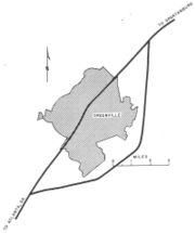
Interstate 185 is located in the city of Greenville, South Carolina
. The northern portion, which ends just shy of the Greenville city limits, was opened in the 1960s and is cosigned with U.S. 29. The southern portion, which connects the I-85/I-185 interchange (exit 42) with the I-385/U.S. 276 interchange (exit 30), was opened as a toll road in 2001 ($1.25 per passenger vehicle). This extension was dubbed the "Southern Connector" and increased I-185 from three to seventeen miles (27 km) in length.
 The Southern Connector was constructed as a public-private partnership
between the South Carolina Department of Transportation
and Interwest Carolina Transportation Group, LLC, a development team that included a not-for-profit corporation called Connector 2000 Association, Inc. (C2A). Under this agreement, C2A operates the toll road under a fifty year license. They were responsible for financing, designing, constructing, operating and maintaining the road during this period and the toll revenue would be used to pay them for these efforts. To finance the project, C2A sold bonds that were tax-exempt under IRS
Rule 63-20, which provides that the bonds sold will be exempt if they finance an activity which is "public in nature."
The highway opened in February 2001, nine months ahead of schedule. By 2007, the Connector 2000 Association was having financial difficulties because ridership on the toll road was not meeting original estimates. In the fall of 2007, they began looking for a concessionaire
to take over the operation and financial liability of the toll road. By early 2008, C2A had received a default notice from their bond trustee In January 2010, the bond trustee missed an interest payment, and the C2A was more than $8 million behind in its payments to SCDOT for the maintenance and license fees under their agreement. On June 24, 2010, the Southern Connector filed for bankruptcy.
Travelers on the Southern Connector can pay using electronic toll collection
facilities. South Carolina uses the PalmettoPass, which can be used on both the Southern Connector and the Cross Island Parkway
on Hilton Head Island
.
.
Greenville, South Carolina
-Law and government:The city of Greenville adopted the Council-Manager form of municipal government in 1976.-History:The area was part of the Cherokee Nation's protected grounds after the Treaty of 1763, which ended the French and Indian War. No White man was allowed to enter, though some families...
. The northern portion, which ends just shy of the Greenville city limits, was opened in the 1960s and is cosigned with U.S. 29. The southern portion, which connects the I-85/I-185 interchange (exit 42) with the I-385/U.S. 276 interchange (exit 30), was opened as a toll road in 2001 ($1.25 per passenger vehicle). This extension was dubbed the "Southern Connector" and increased I-185 from three to seventeen miles (27 km) in length.
Southern Connector
Public-private partnership
Public–private partnership describes a government service or private business venture which is funded and operated through a partnership of government and one or more private sector companies...
between the South Carolina Department of Transportation
South Carolina Department of Transportation
The South Carolina Department of Transportation is a government agency in the US state of South Carolina. Its mission is to build and maintain roads and bridges and administer mass transit services....
and Interwest Carolina Transportation Group, LLC, a development team that included a not-for-profit corporation called Connector 2000 Association, Inc. (C2A). Under this agreement, C2A operates the toll road under a fifty year license. They were responsible for financing, designing, constructing, operating and maintaining the road during this period and the toll revenue would be used to pay them for these efforts. To finance the project, C2A sold bonds that were tax-exempt under IRS
Internal Revenue Service
The Internal Revenue Service is the revenue service of the United States federal government. The agency is a bureau of the Department of the Treasury, and is under the immediate direction of the Commissioner of Internal Revenue...
Rule 63-20, which provides that the bonds sold will be exempt if they finance an activity which is "public in nature."
The highway opened in February 2001, nine months ahead of schedule. By 2007, the Connector 2000 Association was having financial difficulties because ridership on the toll road was not meeting original estimates. In the fall of 2007, they began looking for a concessionaire
Concession (contract)
A concession is a business operated under a contract or license associated with a degree of exclusivity in business within a certain geographical area. For example, sports arenas or public parks may have concession stands. Many department stores contain numerous concessions operated by other...
to take over the operation and financial liability of the toll road. By early 2008, C2A had received a default notice from their bond trustee In January 2010, the bond trustee missed an interest payment, and the C2A was more than $8 million behind in its payments to SCDOT for the maintenance and license fees under their agreement. On June 24, 2010, the Southern Connector filed for bankruptcy.
Travelers on the Southern Connector can pay using electronic toll collection
Electronic toll collection
Electronic toll collection , an adaptation of military "identification friend or foe" technology, aims to eliminate the delay on toll roads by collecting tolls electronically. It is thus a technological implementation of a road pricing concept...
facilities. South Carolina uses the PalmettoPass, which can be used on both the Southern Connector and the Cross Island Parkway
U.S. Route 278
U.S. Route 278 is a parallel route of U.S. Route 78. It currently runs for 1,074 miles from Hilton Head Island, South Carolina to Wickes, Arkansas at U.S. Highway 71/U.S. Highway 59. It might be notable that it is longer than its parent highway, US Hwy-78. US Hwy-278 passes through the states of...
on Hilton Head Island
Hilton Head Island, South Carolina
Hilton Head Island or Hilton Head is a resort town in Beaufort County, South Carolina, United States. It is north of Savannah, Georgia, and south of Charleston. The island gets its name from Captain William Hilton...
.
Exit list
The entire route is in Greenville CountyGreenville County, South Carolina
- External Links :*...
.
| Location | Exit # Exit number An exit number is a number assigned to a road junction, usually an exit from a freeway. It is usually marked on the same sign as the destinations of the exit, as well as a sign in the gore.... |
Destination | Notes |
|---|---|---|---|
| Mauldin Mauldin, South Carolina Mauldin is a city in Greenville County, South Carolina, United States. The population was 15,224 at the 2000 census. It is a principal city of the Greenville–Mauldin–Easley Metropolitan Statistical Area.-Geography:... |
Southbound exit and northbound entrance | ||
| 1C | Signed as exit 1 northbound; no northbound entrance to I-385 north | ||
| 1B | Southbound exit and northbound entance | ||
| 1A | Southbound exit and northbound entrance | ||
| Toll plaza | |||
| 4 | Fork Shoals Road | ||
| 7 | Signed as exits 7A (north) and 7B (south) northbound | ||
| Piedmont Piedmont, South Carolina Piedmont is a census-designated place along the Saluda River in Anderson and Greenville counties in the U.S. state of South Carolina. The population was 4,684 at the 2000 census.... |
10 | ||
| Toll plaza | |||
| 12 | |||
| 14 | South end of US 29 overlap; signed as exits 14A (north) and 14B (south) | ||
| 15 | |||
| Greenville Greenville, South Carolina -Law and government:The city of Greenville adopted the Council-Manager form of municipal government in 1976.-History:The area was part of the Cherokee Nation's protected grounds after the Treaty of 1763, which ended the French and Indian War. No White man was allowed to enter, though some families... |
16 | Washington Avenue, Faris Road | |
| Mills Avenue, Henrydale Avenue | At-grade intersection | ||
| Continuation beyond on Henrydale Avenue | |||