
Indo-Bangladesh enclaves
Encyclopedia
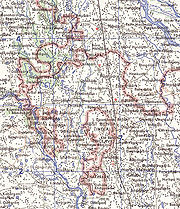
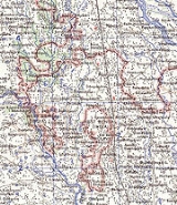
Bangladesh–India border
Bangladesh and India share a border of 2,429 miles. Bangladeshi Divisions of Khulna, Rajshahi, Rangpur, Mymensingh, Sylhet and Chittagong along with Indian states of West Bengal, Assam, Meghalaya, Tripura and Mizoram are situated along the border. The border is more than blotted with numbered pillars...
, in Bangladesh
Bangladesh
Bangladesh , officially the People's Republic of Bangladesh is a sovereign state located in South Asia. It is bordered by India on all sides except for a small border with Burma to the far southeast and by the Bay of Bengal to the south...
and the Indian state
States and territories of India
India is a federal union of states comprising twenty-eight states and seven union territories. The states and territories are further subdivided into districts and so on.-List of states and territories:...
of West Bengal
West Bengal
West Bengal is a state in the eastern region of India and is the nation's fourth-most populous. It is also the seventh-most populous sub-national entity in the world, with over 91 million inhabitants. A major agricultural producer, West Bengal is the sixth-largest contributor to India's GDP...
.
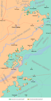
There are 102 Indian enclaves inside Bangladesh and 71 Bangladeshi ones inside India, with a combined population between 50,000 to 100,000. Inside those enclaves are also 28 counter-enclaves and one counter-counter-enclave.
In September 2011, the Prime Ministers of the two countries (Manmohan Singh
Manmohan Singh
Manmohan Singh is the 13th and current Prime Minister of India. He is the only Prime Minister since Jawaharlal Nehru to return to power after completing a full five-year term. A Sikh, he is the first non-Hindu to occupy the office. Singh is also the 7th Prime Minister belonging to the Indian...
of India and Sheikh Hasina
Sheikh Hasina
Sheikh Hasina is a Bangladeshi politician and current Prime Minister of Bangladesh. She has been the President of the Awami League, a major political party, since 1981. She is the eldest of five children of Sheikh Mujibur Rahman, the founding father of Bangladesh and widow of a reputed nuclear...
of Bangladesh) signed an accord on border demarcation and exchange of adversely held enclaves. Under this agreement, the enclave residents may continue residing at their present location or move to the country of their choice.
History
The enclaves were used as stakes in card or chess games centuries ago between two regional kings, the Raja of Cooch Behar and the Maharaja of Rangpur. The little territories were the result of a confused outcome of a treaty between the Kingdom of Koch BiharKoch Bihar
Koch Bihar was a small kingdom located south of the Himalayan kingdom of Bhutan, west of the upper Brahmaputra valley Ahom kingdom, and north-east of the Ganges plain and Bengal. It was formed when the Kamata Kingdom under the Koch dynasty split following the death of Nara Narayan in 1586. The...
and the Mughal Empire
Mughal Empire
The Mughal Empire , or Mogul Empire in traditional English usage, was an imperial power from the Indian Subcontinent. The Mughal emperors were descendants of the Timurids...
.
After the partition of India in 1947, Cooch Behar district
Cooch Behar District
Cooch Behar district is a district of the state of West Bengal, India, as well as the district's namesake town. During the British Raj, the town of Cooch Behar was the seat of a princely state of Koch Bihar, ruled by the Koch dynasty....
was merged with India and Rangpur went to then East Pakistan
East Pakistan
East Pakistan was a provincial state of Pakistan established in 14 August 1947. The provincial state existed until its declaration of independence on 26 March 1971 as the independent nation of Bangladesh. Pakistan recognized the new nation on 16 December 1971. East Pakistan was created from Bengal...
, which became Bangladesh in 1971. In 1974, both countries agreed to exchange the enclaves or at least provide easy access to the enclaves, but since then little has materialised. Talks between the two countries on the issue resumed in 2001, but the lack of a concrete time frame has relegated the issue to the back burner.
The residents of the enclaves live in abysmal conditions, with a lack of water, roads, electricity, schools and medicines. Crime also is rampant, as complaining would mean crossing the international boundary due to the lack of law enforcement resources. Residents of the enclaves may only go to their respective countries on the production of an identity card, after seeking permission from the border guards, causing much resentment. Recently the countries have moved towards an agreement to absorb the enclaves, but the resulting nationality of the current residents remains an impediment as it could have implications for border disputes in other parts of the region.
In September 2011 the governments of India and Bangladesh announced an intention to resolve the issue by means of swapping 162 enclaves, giving residents a choice of nationality.
Bangladesh exclaves
DohogramDohogram
Dohogram is an enclave of Bangladesh, landlocked by India. In 1947 the British partitioned India into two independent states, Pakistan and India, and the problem of the enclave was thus created...
–Angorpotha (Teen Bigha Corridor
Teen Bigha Corridor
The Tin [or Teen] Bigha Corridor is a strip of land belonging to India on the West Bengal–Bangladesh border, which in September, 2011, was leased to Bangladesh so that it can access its Dahagram–Angarpota enclaves...
): A Bangladeshi exclave administrated Pathgram upzila in Lalmonirhat zila lies within the Indian province of West Bengal. The exclave has an area of 25 km2 (10 sq mi) with a resident population of 20,000 people. The exclave lacks all facilities. The lone health complex remains virtually useless for lack of power supply, as India refused to allow Bangladesh to run power lines to the exclave.
The land was actually leased indefinitely to Bangladesh so that they could access the Dehgram–Angalpota enclaves.
Indian exclaves
Dasiarchhara lies 3 km (2 mi) from India and has an area of 7 km² (3 sq mi).Census Report by Bharat Bangladesh Enclave Exchange Co-ordination Committee, 31 July 2010: Total population 9,510; male 4,941, female 4,569; Hindu 640, Muslim 8,870; cultivator 2,426, non-cultivator 840. Total land 1,643.44 acres. Literate 4,148. Disabled 6. With Indian EPIC 193; with BD EPIC 1,173. Under 5 years 378; 6 to 18 years 1,072.
External links
- Brendan R. Whyte, "Waiting for the Esquimo: An historical and documentary study of the Cooch Behar enclaves of India and Bangladesh" (SAGES, University of Melbourne, 2002, revised 2004)
- "Teen Bigha corridor cannot be used for Power supply to Dahogram–Angorpotha Enclaves" at The Daily Star.Net
- Map showing the locations of the enclaves
- Mansi Mehrotra Management of India-Bangladesh Border
- http://www.amanpanchayat.org/index.php?option=com_content&task=view&id=73
- http://www.india-seminar.com/2002/510/510%20urvashi%20butalia.htm
- http://www.tribuneindia.com/2006/20060104/nation.htm#17