
Indiana State Road 105
Encyclopedia
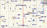
State Road 105 is a 32 miles (51.5 km) north–south road in Northern Indiana
in Huntington
and Whitley
counties.
east of La Fontaine
and runs north, crossing State Road 124
west of Mount Etna
. It then passes through Lost Bridge State Recreation Area and crosses Salamonie Lake before passing through Andrews
where it is concurrent with U.S. Route 24
for about a mile. It crosses State Road 16
and passes through the small town of Bippus
, then crosses State Road 114
before terminating at State Road 5
on the south edge of South Whitley
.
Northern Indiana
Northern Indiana is the region of Indiana including 26 counties bordering parts of Illinois, Michigan, and Ohio. The area is generally sub-classified into other regions. The northwest is economically and culturally intertwined with Chicago, and is considered part of the Chicago metropolitan area...
in Huntington
Huntington County, Indiana
Huntington County is a county located in the U.S. state of Indiana. The county seat and lone city is Huntington. According to Census 2010, the population was 37,124.-Geography:...
and Whitley
Whitley County, Indiana
As of the census of 2000, there were 30,707 people, 11,711 households, and 8,607 families residing in the county. The population density was 92 people per square mile . There were 12,545 housing units at an average density of 37 per square mile...
counties.
Route description
State Road 105 begins at State Road 9Indiana State Road 9
State Road 9 in the U.S. State of Indiana is a long north–south state highway in the eastern portion of Indiana. Its southern terminus is near Columbus at State Road 46, and the northern terminus is at the Michigan/Indiana border between Howe, Indiana, and Sturgis, Michigan, where it...
east of La Fontaine
La Fontaine, Indiana
La Fontaine is a town in Liberty Township, Wabash County, Indiana, United States. The population was 868 at the 2006 census. Its name means "The Fountain" in French, It is correctly pronounced [La-Fon-Tain]....
and runs north, crossing State Road 124
Indiana State Road 124
State Road 124 in the U.S. state of Indiana is an east–west route in the northern part of the state. Its parent route is U.S. Route 24, but the two do not connect.-Route description:...
west of Mount Etna
Mount Etna, Indiana
Mount Etna is a town in Huntington County, Indiana, United States. The population was 94 at the 2010 census. It lies at the intersection of four townships: Jefferson, Lancaster, Polk and Wayne.-Demographics:...
. It then passes through Lost Bridge State Recreation Area and crosses Salamonie Lake before passing through Andrews
Andrews, Indiana
Andrews is a town in Dallas Township, Huntington County, Indiana, United States. The population was 1,149 at the 2010 census.-Geography:Andrews is located at ....
where it is concurrent with U.S. Route 24
U.S. Route 24
U.S. Route 24 is one of the original United States highways of 1926. It originally ran from Pontiac, Michigan, in the east to Kansas City, Missouri, in the west. Today, the highway's eastern terminus is west of Clarkston, Michigan, at an intersection with I-75 and its western terminus is near...
for about a mile. It crosses State Road 16
Indiana State Road 16
State Road 16 is an east–west road in Northern Indiana. Its western terminus is at U.S. Route 41 in Ade, Indiana. Its eastern terminus is at State Road 5 north of Huntington, Indiana.- Route description :...
and passes through the small town of Bippus
Bippus, Indiana
Bippus is an unincorporated town in Warren Township, Huntington County, Indiana, USA....
, then crosses State Road 114
Indiana State Road 114
State Road 114 in the U.S. State of Indiana consists of three discontinuous east–west routes, between the Illinois border and U.S. Route 421, State Road 17 and State Road 25, and State Road 14 and U.S. Route 24.- Western section :...
before terminating at State Road 5
Indiana State Road 5
State Road 5 is a north–south road that runs through northeast Indiana. Its southern terminus is at SR 22 in Upland, and the northern terminus is at SR 120 just north of Shipshewana. The largest city along its path is Huntington...
on the south edge of South Whitley
South Whitley, Indiana
South Whitley is a town in Cleveland Township, Whitley County, Indiana, United States. The population was 1,751 at the 2010 census. South Whitley is a town in the Midwestern tradition of red brick buildings and tree-lined streets.-Geography:...
.