
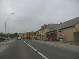
Inagh
Encyclopedia

Ennis
Ennis is the county town of Clare in Ireland. Situated on the River Fergus, it lies north of Limerick and south of Galway. Its name is a shortening of the original ....
in County Clare
County Clare
-History:There was a Neolithic civilisation in the Clare area — the name of the peoples is unknown, but the Prehistoric peoples left evidence behind in the form of ancient dolmen; single-chamber megalithic tombs, usually consisting of three or more upright stones...
, Ireland
Ireland
Ireland is an island to the northwest of continental Europe. It is the third-largest island in Europe and the twentieth-largest island on Earth...
. It comprises seven townland
Townland
A townland or bally is a small geographical division of land used in Ireland. The townland system is of Gaelic origin—most townlands are believed to pre-date the Norman invasion and most have names derived from the Irish language...
s lying north-east of Mount Callan
Mount Callan
Slievecallan is a mountain 391 metres high. It is the third highest mountain in County Clare, Ireland.The mountain sits more or less in the centre of the triangle formed by the villages of Miltown Malbay, Inagh and Connolly, in the west of County Clare. The regional road R474 , passes on the...
. The village is situated on the N85
N85 road (Ireland)
The N85 road is a national secondary road in Ireland connecting Ennis and Ennistymon. The route connects to the M18 Ennis bypass and forms part of the Ennis outer ring road as the "N85 Western Relief Road". From Ennis the route continues in a north - west direction and terminates at the junction...
, Ennis
Ennis
Ennis is the county town of Clare in Ireland. Situated on the River Fergus, it lies north of Limerick and south of Galway. Its name is a shortening of the original ....
- Ennistymon / Lahinch
Lahinch
Lahinch or Lehinch is a village on Liscannor Bay, on the northwest coast of County Clare, in northern Munster, Ireland. It lies on the N67 national secondary road....
road, making Inagh a popular tourist route serving north and west Clare.
Inagh has seen some recent development, including a new housing estate and the new Ark Crèche facility, with more development having been granted planning permission. Plans are also afoot to develop the parish hall (and adjoining old national school building) further. Inagh is also home to the organic goat's milk cheese farm of St. Tola.
There are a number of activities groups in Inagh such as the Youth Club, angling, walking, golfing and reading clubs. There are also active hurling
Hurling
Hurling is an outdoor team game of ancient Gaelic origin, administered by the Gaelic Athletic Association, and played with sticks called hurleys and a ball called a sliotar. Hurling is the national game of Ireland. The game has prehistoric origins, has been played for at least 3,000 years, and...
(currently amalgamating with Kilnamona hurling club) and camogie
Camogie
Camogie is an Irish stick-and-ball team sport played by women; it is almost identical to the game of hurling played by men. Camogie is played by 100,000 women in Ireland and world wide, largely among Irish communities....
clubs, who have enjoyed recent success. Inagh has had a strong tradition of Irish music and dancing. Many famous traditional musicians have played in Inagh and the parish has produced some fine musicians of its own.
See also
- List of towns and villages in Ireland