

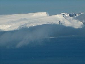
Ilinden Peak
Encyclopedia
Breznik Heights
Breznik Heights rises to over 600 m in the southeast part of Greenwich Island. They extend 12 km between Santa Cruz Point in the north east and the base of the moraine spit at the mouth of Yankee Harbour in the southwest...
on Greenwich Island, Antarctica. The peak has precipitous and partly ice-free south slopes, and surmounts Zheravna Glacier
Zheravna Glacier
Zheravna Glacier is a glacier on Greenwich Island, Antarctica. The glacier is bounded by Razgrad Peak to the west, Ilinden Peak and Momchil Peak to the north, and Viskyar Ridge to the east, extending 2 km in the east-west direction, and 1.8 km in the north-south direction...
to the south, Solis Glacier
Solis Glacier
Solis Glacier is a glacier on Greenwich Island in the South Shetland Islands, Antarctica extending 2.8 km in southeast-northwest direction and 1.8 km in southwest-northeast direction and draining the north slopes of Breznik Heights to flow northwestwards into Yankee Harbour.The feature...
to the northwest, and Fuerza Aérea Glacier
Fuerza Aérea Glacier
Fuerza Aérea Glacier is a glacier on Greenwich Island in the South Shetland Islands, Antarctica extending 4.5 km in northeast-southwest direction and 2 km in southeast-northwest direction and draining the northwest slopes of Breznik Heights to flow northwestwards into Discovery Bay.The...
to the north-northeast.
The feature is "named after the settlement of Ilinden
Ilinden, Blagoevgrad Province
Ilinden, Blagoevgrad Province is a village in the municipality of Hadzhidimovo, in Blagoevgrad Province, Bulgaria....
in Southwestern Bulgaria
Bulgaria
Bulgaria , officially the Republic of Bulgaria , is a parliamentary democracy within a unitary constitutional republic in Southeast Europe. The country borders Romania to the north, Serbia and Macedonia to the west, Greece and Turkey to the south, as well as the Black Sea to the east...
, in connection with the 1903 Bulgarian uprising of Ilinden-Preobrazhenie
Ilinden-Preobrazhenie Uprising
The Ilinden–Preobrazhenie Uprising or simply the Ilinden Uprising of August 1903 |Macedonia]] affected most of the central and southwestern parts of the Monastir Vilayet receiving the support mainly of the local Bulgarian peasants and to some extent of the Aromanian population of the region...
for the liberation of Macedonia
Macedonia (region)
Macedonia is a geographical and historical region of the Balkan peninsula in southeastern Europe. Its boundaries have changed considerably over time, but nowadays the region is considered to include parts of five Balkan countries: Greece, the Republic of Macedonia, Bulgaria, Albania, Serbia, as...
and Odrin (Adrianople) Thrace
Thrace
Thrace is a historical and geographic area in southeast Europe. As a geographical concept, Thrace designates a region bounded by the Balkan Mountains on the north, Rhodope Mountains and the Aegean Sea on the south, and by the Black Sea and the Sea of Marmara on the east...
".
Location
The peak is located at 62°32′08.5"S 59°41′43"W which is 940 m north of Maystora PeakMaystora Peak
Maystora Peak is a rocky peak rising to 350 m in Breznik Heights on Greenwich Island, Antarctica. Situated 580 m east of Razgrad Peak, 940 m south by west of Ilinden Peak, 2.13 km west of Viskyar Ridge, and 1.38 km northeast of the highest point of Ephraim Bluff. Overlooking...
, 1.22 km northeast of Razgrad Peak
Razgrad Peak
Razgrad Peak is an ice-covered peak rising to 550 m in Breznik Heights, Greenwich Island, Antarctica. The peak is located 740 m southeast of Terter Peak, 1.7 km southwest of Momchil Peak, 2.7 km west of the summit of Viskyar Ridge, and 1.51 km north-northeast of the coastal point...
, 1.18 km east by north of Terter Peak
Terter Peak
Terter Peak is an ice-covered peak rising to 570 m in Breznik Heights, Greenwich Island in the South Shetland Islands, Antarctica surmounting Wulfila Glacier to the southwest, Solis Glacier to the northwest and Zheravna Glacier to the southeast.-Location:The peak is located at which is 740 m...
, 2.87 km east of the highest point of Oborishte Ridge
Oborishte Ridge
Oborishte Ridge has an elevation of 340 m in the southwest extremity of Breznik Heights, Greenwich Island in the South Shetland Islands, Antarctica. Extending 1.7 km along the southeast coast of Yankee Harbour and 950 m wide. Ice-free surface area...
, 4.1 km south of Ferrer Point
Ferrer Point
Ferrer Point is a point projecting 700 m into the south part of Discovery Bay, Greenwich Island in the South Shetland Islands, Antarctica with an adjacent ice-free area of...
, 590 m west of Momchil Peak
Momchil Peak
Momchil Peak is an ice-covered peak rising to 625 m in Breznik Heights, Greenwich Island in the South Shetland Islands, Antarctica...
, 2 km west-northwest of the summit of Viskyar Ridge
Viskyar Ridge
Viskyar Ridge is a rocky ridge rising to 600 m and extending 2.5 km in north-south direction in Breznik Heights, Greenwich Island in the South Shetland Islands, Antarctica. The ice-free surface area of the ridge is...
and 3.32 km northwest of Sartorius Point
Sartorius Point
Sartorius Point is a sharp ice-free tipped point formed by an offshoot of Viskyar Ridge and marking the south extremity of Greenwich Island in the South Shetland Islands, Antarctica. The point separates the termini of Zheravna Glacier to the west and Targovishte Glacier to the east...
. British mapping in 1968, Bulgarian topographic survey Tangra 2004/05
Tangra 2004/05
The Tangra 2004/05 Expedition was commissioned by the Antarctic Place-names Commission at the Ministry of Foreign Affairs of Bulgaria, managed by the Manfred Wörner Foundation, and supported by the Bulgarian Antarctic Institute, the Institute of Mathematics and Informatics at the Bulgarian Academy...
and mapping in 2009.
Maps
- L.L. Ivanov et al. Antarctica: Livingston Island and Greenwich Island, South Shetland Islands. Scale 1:100000 topographic map. Sofia: Antarctic Place-names Commission of Bulgaria, 2005.
- L.L. Ivanov. Antarctica: Livingston Island and Greenwich, Robert, Snow and Smith Islands. Scale 1:120000 topographic map. Troyan: Manfred Wörner Foundation, 2009. ISBN 978-954-92032-6-4