
.gif)
Hurricane Caroline (1975)
Encyclopedia
Hurricane Caroline was the third named storm, second hurricane and first major hurricane of the 1975 Atlantic hurricane season
. Caroline formed on August 24, 1975 as a tropical depression which crossed Cuba
and Gulf of Mexico
and became a tropical storm on August 29. Caroline then rapidly became a Category 3
hurricane with its winds peaking at 115 mph (185 km/h) before making landfall 100 miles (160 km) south of Brownsville
, Texas
, before rapidly weakening and dissipated on September 1.
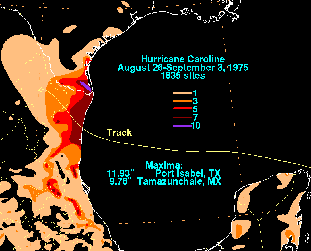
Caroline dropped heavy rainfall across southern Texas and northern Mexico
causing minor flooding and relieving drought stricken areas. Offshore, strong currents caused by the storm caused two indirect fatalities in Galveston, Texas
. A damage estimate from Caroline is unknown.
exited the west coast of Africa
on August 15 and rapidly moved westward at 17 mph (28 km/h) along the Intertropical Convergence Zone
(ITCZ). On August 18, the system turned northeast away from the ITCZ and slowed down by the time it was 600 miles (965 km) northeast of Puerto Rico
. On August 22 and 23, the system changed course for the second time as it turned to the southwest. By noon on August 24, satellite
imagery showed the disturbance establishing a closed area of circulation with winds reaching 25 mph (40 km/h) and the barometric pressure falling to 1011 mb. The disturbance then became Tropical Depression Five as it neared northeastern Cuba
and southeastern Bahamas. The depression crossed Cuba where it momentarily weakened back to a tropical wave. The storm then regained tropical depression status on August 27 as it continued westward into the Gulf of Mexico
.
After brushing the northeastern tip of the Yucatán Peninsula
, Tropical Depression Five continued to move west at 8 mph (13 km/h) as the storm entered an area favorable for intensification. On August 29, the tropical depression strengthened to a tropical storm and was named Caroline by the National Hurricane Center
. By that time the storm was only 400 miles east-southeast of Brownsville, Texas
. Caroline forward speed slowed down to 5 mph (8 km/h) while intensifying and on the same day, Caroline was upgraded to hurricane status. Before making landfall, two hurricane hunter aircraft flew into Caroline's center on August 30, where data collected from the aircraft showed a barometric pressure reading of 987 mb and winds of 80 mph (130 km/h). Six hours later the hurricane rapidly intensified, with winds reaching 115 mph (185 km/h) and the pressure dropping to 973 mb. The pressure then fell to 963 mb before the storm made landfall 100 miles (160 km) south of Brownsville, Texas
on August 31. Caroline rapidly weakened to a tropical depression twelve hours after landfall and dissipated on September 1 over northeastern Mexico
.
 Two NOAA Research planes (flights 750830A and 750830F) conducted experiments into Caroline. The experiments were to study and measure the wind velocity and the environment inside and around the eye as well as the boundary layer of the hurricane. The results of the experiments concluded that Caroline had a higher dissipation rate than normal hurricanes, with the dissipating rate averaging at 30%. This conclusion suggested that energy in a hurricane dissipating internally above the surface layer is two times higher than energy dissipating at the surface.
began to issue advisories for coastal sections of south Texas
and northern Mexico
. Small water craft were also advised of the deteriorating conditions. In Texas
, local officials in Cameron County
opened storm shelters in anticipation that the storm might make landfall. Emergency commutations and relief and clean up organizations were notified of the upcoming threat. In addition, relief squads from the American Red Cross
moved to south Texas
in case the storm made landfall.
In Mexico
, coastal residents evacuated to storm shelters south of Tampico
. Elsewhere, 300 residents were evacuated to storm shelters in Soto del la Marina 55 miles (88 km) from Santa Rosa
. In northeast Mexico
, 150 residents evacuated to shelters in San Fernando
, 85 miles (137 km) south of Brownsville
.
 Caroline brushed the southeastern Bahamas and made landfall in eastern Cuba
as a tropical depression though its effects, if any are unknown. Caroline’s compact wind field produced 48 mph (78 km/h) winds in Brownsville, Texas
. The storm also dropped heavy rain across southern Texas
which caused minor flooding. Caroline also produced storm tide
s 1–4 feet (0.3-1.2 m) above normal along coastal sections of southern Texas. Overall damage in southern Texas was minor and the rainfall produced by Caroline helped end a prolonged drought in the Rio Grande Valley
area of Texas. Caroline caused two indirect fatalities due to drowning incidents in Galveston, Texas
.
In Mexico
, the storm brought 10 feet (3 m) storm tides to coastal sections of the country and 5-10 in (127–254 mm) of rain to inland areas. The rainfalls caused moderate flooding which caused 1,000 people to evacuate and left moderate damage to homes and businesses. However, the rains broke an eight month drought that was affecting inland areas of northern Mexico
. Along the coast, several small villages sustained significant damage from the hurricane's storm surge
. There were no reported fatalities or injuries from Hurricane Caroline’s effects on Mexico
.
Because its effects was minimal, the name Caroline was not retired. In 1979 a change in the naming list prevented the use of the name and as a result it was the only use of the name Caroline for the Atlantic basin
.
1975 Atlantic hurricane season
The 1975 Atlantic hurricane season officially began on June 1, 1975, and lasted until November 30, 1975. These dates conventionally delimit the period of each year when most tropical cyclones form in the Atlantic basin...
. Caroline formed on August 24, 1975 as a tropical depression which crossed Cuba
Cuba
The Republic of Cuba is an island nation in the Caribbean. The nation of Cuba consists of the main island of Cuba, the Isla de la Juventud, and several archipelagos. Havana is the largest city in Cuba and the country's capital. Santiago de Cuba is the second largest city...
and Gulf of Mexico
Gulf of Mexico
The Gulf of Mexico is a partially landlocked ocean basin largely surrounded by the North American continent and the island of Cuba. It is bounded on the northeast, north and northwest by the Gulf Coast of the United States, on the southwest and south by Mexico, and on the southeast by Cuba. In...
and became a tropical storm on August 29. Caroline then rapidly became a Category 3
Tropical cyclone scales
Tropical systems are officially ranked on one of several tropical cyclone scales according to their maximum sustained winds and in what oceanic basin they are located...
hurricane with its winds peaking at 115 mph (185 km/h) before making landfall 100 miles (160 km) south of Brownsville
Brownsville, Texas
Brownsville is a city in the southernmost tip of the state of Texas, in the United States. It is located on the northern bank of the Rio Grande, directly north and across the border from Matamoros, Tamaulipas, Mexico. Brownsville is the 16th largest city in the state of Texas with a population of...
, Texas
Texas
Texas is the second largest U.S. state by both area and population, and the largest state by area in the contiguous United States.The name, based on the Caddo word "Tejas" meaning "friends" or "allies", was applied by the Spanish to the Caddo themselves and to the region of their settlement in...
, before rapidly weakening and dissipated on September 1.
Caroline dropped heavy rainfall across southern Texas and northern Mexico
Mexico
The United Mexican States , commonly known as Mexico , is a federal constitutional republic in North America. It is bordered on the north by the United States; on the south and west by the Pacific Ocean; on the southeast by Guatemala, Belize, and the Caribbean Sea; and on the east by the Gulf of...
causing minor flooding and relieving drought stricken areas. Offshore, strong currents caused by the storm caused two indirect fatalities in Galveston, Texas
Galveston, Texas
Galveston is a coastal city located on Galveston Island in the U.S. state of Texas. , the city had a total population of 47,743 within an area of...
. A damage estimate from Caroline is unknown.
Meteorological history
A tropical waveTropical wave
Tropical waves, easterly waves, or tropical easterly waves, also known as African easterly waves in the Atlantic region, are a type of atmospheric trough, an elongated area of relatively low air pressure, oriented north to south, which move from east to west across the tropics causing areas of...
exited the west coast of Africa
Africa
Africa is the world's second largest and second most populous continent, after Asia. At about 30.2 million km² including adjacent islands, it covers 6% of the Earth's total surface area and 20.4% of the total land area...
on August 15 and rapidly moved westward at 17 mph (28 km/h) along the Intertropical Convergence Zone
Intertropical Convergence Zone
The Intertropical Convergence Zone , known by sailors as The Doldrums, is the area encircling the earth near the equator where winds originating in the northern and southern hemispheres come together....
(ITCZ). On August 18, the system turned northeast away from the ITCZ and slowed down by the time it was 600 miles (965 km) northeast of Puerto Rico
Puerto Rico
Puerto Rico , officially the Commonwealth of Puerto Rico , is an unincorporated territory of the United States, located in the northeastern Caribbean, east of the Dominican Republic and west of both the United States Virgin Islands and the British Virgin Islands.Puerto Rico comprises an...
. On August 22 and 23, the system changed course for the second time as it turned to the southwest. By noon on August 24, satellite
Satellite
In the context of spaceflight, a satellite is an object which has been placed into orbit by human endeavour. Such objects are sometimes called artificial satellites to distinguish them from natural satellites such as the Moon....
imagery showed the disturbance establishing a closed area of circulation with winds reaching 25 mph (40 km/h) and the barometric pressure falling to 1011 mb. The disturbance then became Tropical Depression Five as it neared northeastern Cuba
Cuba
The Republic of Cuba is an island nation in the Caribbean. The nation of Cuba consists of the main island of Cuba, the Isla de la Juventud, and several archipelagos. Havana is the largest city in Cuba and the country's capital. Santiago de Cuba is the second largest city...
and southeastern Bahamas. The depression crossed Cuba where it momentarily weakened back to a tropical wave. The storm then regained tropical depression status on August 27 as it continued westward into the Gulf of Mexico
Gulf of Mexico
The Gulf of Mexico is a partially landlocked ocean basin largely surrounded by the North American continent and the island of Cuba. It is bounded on the northeast, north and northwest by the Gulf Coast of the United States, on the southwest and south by Mexico, and on the southeast by Cuba. In...
.
After brushing the northeastern tip of the Yucatán Peninsula
Yucatán Peninsula
The Yucatán Peninsula, in southeastern Mexico, separates the Caribbean Sea from the Gulf of Mexico, with the northern coastline on the Yucatán Channel...
, Tropical Depression Five continued to move west at 8 mph (13 km/h) as the storm entered an area favorable for intensification. On August 29, the tropical depression strengthened to a tropical storm and was named Caroline by the National Hurricane Center
National Hurricane Center
The National Hurricane Center , located at Florida International University in Miami, Florida, is the division of the National Weather Service responsible for tracking and predicting weather systems within the tropics between the Prime Meridian and the 140th meridian west poleward to the 30th...
. By that time the storm was only 400 miles east-southeast of Brownsville, Texas
Brownsville, Texas
Brownsville is a city in the southernmost tip of the state of Texas, in the United States. It is located on the northern bank of the Rio Grande, directly north and across the border from Matamoros, Tamaulipas, Mexico. Brownsville is the 16th largest city in the state of Texas with a population of...
. Caroline forward speed slowed down to 5 mph (8 km/h) while intensifying and on the same day, Caroline was upgraded to hurricane status. Before making landfall, two hurricane hunter aircraft flew into Caroline's center on August 30, where data collected from the aircraft showed a barometric pressure reading of 987 mb and winds of 80 mph (130 km/h). Six hours later the hurricane rapidly intensified, with winds reaching 115 mph (185 km/h) and the pressure dropping to 973 mb. The pressure then fell to 963 mb before the storm made landfall 100 miles (160 km) south of Brownsville, Texas
Brownsville, Texas
Brownsville is a city in the southernmost tip of the state of Texas, in the United States. It is located on the northern bank of the Rio Grande, directly north and across the border from Matamoros, Tamaulipas, Mexico. Brownsville is the 16th largest city in the state of Texas with a population of...
on August 31. Caroline rapidly weakened to a tropical depression twelve hours after landfall and dissipated on September 1 over northeastern Mexico
Mexico
The United Mexican States , commonly known as Mexico , is a federal constitutional republic in North America. It is bordered on the north by the United States; on the south and west by the Pacific Ocean; on the southeast by Guatemala, Belize, and the Caribbean Sea; and on the east by the Gulf of...
.
Experiments
Preparations
The National Hurricane CenterNational Hurricane Center
The National Hurricane Center , located at Florida International University in Miami, Florida, is the division of the National Weather Service responsible for tracking and predicting weather systems within the tropics between the Prime Meridian and the 140th meridian west poleward to the 30th...
began to issue advisories for coastal sections of south Texas
Texas
Texas is the second largest U.S. state by both area and population, and the largest state by area in the contiguous United States.The name, based on the Caddo word "Tejas" meaning "friends" or "allies", was applied by the Spanish to the Caddo themselves and to the region of their settlement in...
and northern Mexico
Mexico
The United Mexican States , commonly known as Mexico , is a federal constitutional republic in North America. It is bordered on the north by the United States; on the south and west by the Pacific Ocean; on the southeast by Guatemala, Belize, and the Caribbean Sea; and on the east by the Gulf of...
. Small water craft were also advised of the deteriorating conditions. In Texas
Texas
Texas is the second largest U.S. state by both area and population, and the largest state by area in the contiguous United States.The name, based on the Caddo word "Tejas" meaning "friends" or "allies", was applied by the Spanish to the Caddo themselves and to the region of their settlement in...
, local officials in Cameron County
Cameron County, Texas
Cameron County is the southernmost county located in the U.S. state of Texas. In 2010, its population was 406,220. Its county seat is Brownsville. Cameron was founded in 1848...
opened storm shelters in anticipation that the storm might make landfall. Emergency commutations and relief and clean up organizations were notified of the upcoming threat. In addition, relief squads from the American Red Cross
American Red Cross
The American Red Cross , also known as the American National Red Cross, is a volunteer-led, humanitarian organization that provides emergency assistance, disaster relief and education inside the United States. It is the designated U.S...
moved to south Texas
Texas
Texas is the second largest U.S. state by both area and population, and the largest state by area in the contiguous United States.The name, based on the Caddo word "Tejas" meaning "friends" or "allies", was applied by the Spanish to the Caddo themselves and to the region of their settlement in...
in case the storm made landfall.
In Mexico
Mexico
The United Mexican States , commonly known as Mexico , is a federal constitutional republic in North America. It is bordered on the north by the United States; on the south and west by the Pacific Ocean; on the southeast by Guatemala, Belize, and the Caribbean Sea; and on the east by the Gulf of...
, coastal residents evacuated to storm shelters south of Tampico
Tampico
Tampico is a city and port in the state of Tamaulipas, in the country of Mexico. It is located in the southeastern part of the state, directly north across the border from Veracruz. Tampico is the third largest city in Tamaulipas, and counts with a population of 309,003. The Metropolitan area of...
. Elsewhere, 300 residents were evacuated to storm shelters in Soto del la Marina 55 miles (88 km) from Santa Rosa
Santa Rosa
Santa Rosa is the Spanish and Portuguese name for Saint Rose. It may also refer to:-Places: Argentina:*Santa Rosa, La Pampa*Santa Rosa de Calamuchita *Santa Rosa de Calchines *Santa Rosa de Río Primero...
. In northeast Mexico
Mexico
The United Mexican States , commonly known as Mexico , is a federal constitutional republic in North America. It is bordered on the north by the United States; on the south and west by the Pacific Ocean; on the southeast by Guatemala, Belize, and the Caribbean Sea; and on the east by the Gulf of...
, 150 residents evacuated to shelters in San Fernando
San Fernando, Chiapas
San Fernando is a town and one of the 119 Municipalities of Chiapas, in southern Mexico.As of 2005, the municipality had a total population of 26,436. It covers an area of 258.3 km²....
, 85 miles (137 km) south of Brownsville
Brownsville, Texas
Brownsville is a city in the southernmost tip of the state of Texas, in the United States. It is located on the northern bank of the Rio Grande, directly north and across the border from Matamoros, Tamaulipas, Mexico. Brownsville is the 16th largest city in the state of Texas with a population of...
.
Impact
Cuba
The Republic of Cuba is an island nation in the Caribbean. The nation of Cuba consists of the main island of Cuba, the Isla de la Juventud, and several archipelagos. Havana is the largest city in Cuba and the country's capital. Santiago de Cuba is the second largest city...
as a tropical depression though its effects, if any are unknown. Caroline’s compact wind field produced 48 mph (78 km/h) winds in Brownsville, Texas
Brownsville, Texas
Brownsville is a city in the southernmost tip of the state of Texas, in the United States. It is located on the northern bank of the Rio Grande, directly north and across the border from Matamoros, Tamaulipas, Mexico. Brownsville is the 16th largest city in the state of Texas with a population of...
. The storm also dropped heavy rain across southern Texas
Texas
Texas is the second largest U.S. state by both area and population, and the largest state by area in the contiguous United States.The name, based on the Caddo word "Tejas" meaning "friends" or "allies", was applied by the Spanish to the Caddo themselves and to the region of their settlement in...
which caused minor flooding. Caroline also produced storm tide
Storm tide
A storm tide is a tide with a high flood period caused by a storm. Storm tides can be a severe danger to the coast and the people living along the coast. The water level can rise to more than 5 meters above the normal tide....
s 1–4 feet (0.3-1.2 m) above normal along coastal sections of southern Texas. Overall damage in southern Texas was minor and the rainfall produced by Caroline helped end a prolonged drought in the Rio Grande Valley
Rio Grande Valley
The Rio Grande Valley or the Lower Rio Grande Valley, informally called The Valley, is an area located in the southernmost tip of South Texas...
area of Texas. Caroline caused two indirect fatalities due to drowning incidents in Galveston, Texas
Galveston, Texas
Galveston is a coastal city located on Galveston Island in the U.S. state of Texas. , the city had a total population of 47,743 within an area of...
.
In Mexico
Mexico
The United Mexican States , commonly known as Mexico , is a federal constitutional republic in North America. It is bordered on the north by the United States; on the south and west by the Pacific Ocean; on the southeast by Guatemala, Belize, and the Caribbean Sea; and on the east by the Gulf of...
, the storm brought 10 feet (3 m) storm tides to coastal sections of the country and 5-10 in (127–254 mm) of rain to inland areas. The rainfalls caused moderate flooding which caused 1,000 people to evacuate and left moderate damage to homes and businesses. However, the rains broke an eight month drought that was affecting inland areas of northern Mexico
Mexico
The United Mexican States , commonly known as Mexico , is a federal constitutional republic in North America. It is bordered on the north by the United States; on the south and west by the Pacific Ocean; on the southeast by Guatemala, Belize, and the Caribbean Sea; and on the east by the Gulf of...
. Along the coast, several small villages sustained significant damage from the hurricane's storm surge
Storm surge
A storm surge is an offshore rise of water associated with a low pressure weather system, typically tropical cyclones and strong extratropical cyclones. Storm surges are caused primarily by high winds pushing on the ocean's surface. The wind causes the water to pile up higher than the ordinary sea...
. There were no reported fatalities or injuries from Hurricane Caroline’s effects on Mexico
Mexico
The United Mexican States , commonly known as Mexico , is a federal constitutional republic in North America. It is bordered on the north by the United States; on the south and west by the Pacific Ocean; on the southeast by Guatemala, Belize, and the Caribbean Sea; and on the east by the Gulf of...
.
Because its effects was minimal, the name Caroline was not retired. In 1979 a change in the naming list prevented the use of the name and as a result it was the only use of the name Caroline for the Atlantic basin
Atlantic Basin
The Atlantic Basin is the Atlantic Ocean.Atlantic Basin may also refer to:* Atlantic Basin Iron Works, an ironworks that operated in Brooklyn, New York, in the early to mid-20th century...
.