

Hope, Providence, Rhode Island
Encyclopedia
Providence, Rhode Island
Providence is the capital and most populous city of Rhode Island and was one of the first cities established in the United States. Located in Providence County, it is the third largest city in the New England region...
, Rhode Island
Rhode Island
The state of Rhode Island and Providence Plantations, more commonly referred to as Rhode Island , is a state in the New England region of the United States. It is the smallest U.S. state by area...
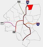
. To the west, it is bounded by North Main Street, the North Burial Ground
North Burial Ground
The North Burial Ground is a cemetery in Providence, Rhode Island, dating to 1700. Providence had no public burial ground and no Common until the year 1700 because Rhode Island's religious and government institutions were so rigorously kept distinct, dating back to its founding by Roger...
, and Interstate 95
Interstate 95 in Rhode Island
Interstate 95, the main north–south Interstate Highway on the east coast of the United States, runs generally southwest-northeast through the U.S. state of Rhode Island. It runs from the border with Connecticut near Westerly through Warwick and Providence and to the Massachusetts state line...
, while Rochambeau Ave, Hope Street, and the Providence-Pawtucket
Pawtucket, Rhode Island
Pawtucket is a city in Providence County, Rhode Island, United States. The population was 71,148 at the 2010 census. It is the fourth largest city in the state.-History:...
city line roughly delineate its boundaries to the south, east, and north respectively. Hope is sometimes referred to as Summit, named for the street that runs through the middle of the neighborhood. Though "Hope" is officially recognized, residents and the local neighborhood organization more often use "Summit".
The area that is now Hope was first settled in the seventeenth century by farmers and tavernkeepers following present-day North Main Street out of the center of Providence, establishing a strong rural community.
Like many of Providence's neighborhoods, Hope did not experience appreciable development until the area was connected to downtown Providence
Downtown, Providence, Rhode Island
Downtown, also known as Downcity, is the central economic, political, and cultural district of the city of Providence, Rhode Island. It is bounded on the east by Canal Street and the Providence River, to the north by Smith Street, to the west by Interstate 95, and to the south by Henderson Street...
by streetcar, happening in 1875. Large farming lots gave way to subdivision and the establishment of single-family homes. In the 1920s, many of these were bought by a growing community of Russian Jews who would have a strong presence in the area until World War II.
In 1945, Miriam Hospital
Miriam Hospital
The Miriam Hospital is a private, not-for-profit hospital at 164 Summit Avenue in Providence, Rhode Island. It a major teaching affiliate associated with the Alpert Medical School of Brown University.-History:...
relocated to Hope from its West End
West End, Providence, Rhode Island
The West End is a neighborhood in the southwestern part of Providence, Rhode Island in the region often referred to as the South Side. Its boundaries are delineated by Westminster Street to the north, Huntington Avenue to the south, Elmwood Avenue to the east and the railroad tracks with Route 10...
lot. Having expanded four times since then and opening a new medical building in 1989, the hospital now occupies a full two city blocks, with a parking lot filling out the third, now stretching from 5th Street to 8th Street.
Today, a community organization named the Summit Neighborhood Association publishes a quarterly newspaper and encourages participation in neighborhoods activities.
As of 1990 Census, the neighborhood was home to 3464 individuals and was roughly 80% non-Hispanic white, 8.2% black, 4% Hispanic, 2% Asian or pacific islander with the remaining 6% either reporting other or multiple races. Median household income was $47,764, above the city-wide average of $26,867. Approximately 5% of families were living below the poverty line, compared with 24% for the city as a whole.
About 40% of housing stock were single family units, with the remaining being duplex or multi-family units. The median price for a single family house was $247,500, nearly twice the city-wide average of $130,000. Owner occupancy has been steadily dropping, from 56% in 1980 to 48% in 1990.