

History of Richfield, Minnesota
Encyclopedia
Richfield
, is a city in eastern Minnesota
. It is a part of the Minneapolis metro area.
By the late 1830s, the fortress served as a destination for newcomers—lumbermen, missionaries, farmers, traders and travelers—migrating to the borderlands people were now calling “Minisota.”
Fort Snelling’s garrison made up the bulk of the area’s population, along with Henry Sibley and Alexander Faribault’s seventy-five person American Fur Company operation. The federal government licensed American Fur to locate its base at Mendota
, across the Mississippi
from the fort. Meanwhile, small settlements of traders, farmers, missionaries and refugees began to develop outside the walls of the fort, some with permission, some without. These residents built communities on land that would become known as Richfield.
The forty citizens in attendance at the organizational meeting selected Riley Bartholomew
temporary chairman of the meeting, with Asa Keith moderator, and Alonzo Sawtelle clerk. Voters elected George Odell assessor, James Dunsmoor overseer of the poor, George W. Townsend and William Moffett constables, and George Irwin and Bartholomew as justices of the peace. William Finch was elected to the Hennepin County Board of Commissioners. Minutes of the town’s 1858 organizational meeting at Richland’s mill school show voters decided the community would “be hereafter known by the name of Richfield.”
Richfield taxpayers budgeted four hundred dollars for expenses and added a twenty-five-cent tax on every one hundred dollars of real estate for road improvement. Richland Mills, later known as Richfield Mills, became the de facto town and business center. The Harmony post office, south of the mill on today’s Lyndale Avenue, opened in 1854. Postmaster James Dunsmoor named the mail center after his hometown in Maine.
Other businesses, including a blacksmith shop and meat market, clustered around the mill at this town hub. Small and scattered farms dotted the Richfield landscape.
The fields of Richfield proved bountiful for the settlers. Early crops included corn, wheat and oats. Wheat immediately became the “cash” crop, sold in the area’s first major market, St. Paul
. Those in the southern parts of Hennepin County found it more profitable to haul their wheat crop to St. Paul than to the St. Anthony Falls district. This occurred in the days before “King Wheat” and the evolution of Minneapolis into a milling center. In 1860 H. H. Hopkins of Richfield wrote to Minnesota Farmer and Gardener claiming he was getting a good yield of twenty-seven bushels of wheat per acre while handling the threshing himself. His oat yield varied from forty to seventy-five bushels per acre.
Settlers from Maine
made up 35 percent of the total number of U.S.-born adults (eighteen years old or older) in 1860 Richfield. New York immigrants, at 21 percent, were a notable but distant second. Maine’s 120 and New York’s 74 adults made up more than half the American-born newcomers in the town. Fifty-eight immigrants from Ireland
represented just under half of the 119 adults from other nations. Just three of Richfield’s citizens had been born in Minnesota.
 The beginnings of Richfield date back to the 1850s, when it was still a small farming community. Today’s boundaries differ markedly from those originally set forth on April 10, 1858, by the Hennepin County Board of Commissioners when they established the towns of Richland, Minneapolis, Bloomington
and Eden Prairie
. Electors of the newly created Richland met on May 11, 1858, and changed the name of their town to Richfield.
The boundaries of Richfield included all of congressional township 28 Range 24 and parts of adjoining townships, which together contained about sixty-three square miles. Richfield originally ranged to Minneapolis’s Lake Street on the north, to what is now Highway 169 on the west, to Bloomington on the south, and to Fort Snelling and the Minnesota and Mississippi rivers on the east.
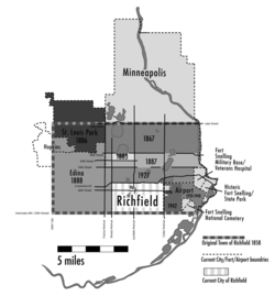
Parts of Richfield were later lost to neighboring towns or villages through annexation. An 1886 partition of Richfield created the village of St. Louis Park, and a later division approved April 5, 1889, produced the village of Edina. Minneapolis absorbed sizeable portions of Richfield territory through legislative action or annexations in 1867, 1883, 1887 and 1927. The growth of Twin Cities International Airport during the last half of the twentieth century and addition of land to the Fort Snelling compound meant further reductions.
These border changes have an effect on the telling of Richfield’s history. Some significant sites in state and local history once located in the community are no longer within its boundaries. For example, the site of Richfield Mills, the township’s original business and political center, is now in Minneapolis at Lyndale Avenue and Minnehaha Creek. Places such as Lake Calhoun, Lake Harriet and Minnehaha Falls once were part of Richfield.
first reached Fort Snelling in 1837 where he worked as a sutler, selling goods to soldiers. By the time of his outing with Mayer, Steele had branched out into lumbering and merchandising. While the artist Mayer marveled at the beauty of the rolling prairies of the future Richfield, Frank Steele saw farmland platted, subdivided, and easily sold to settlers—hopefully by him. Steele deduced that much of the Fort Snelling reservation would be sold by the government for development and was already working on a plan to acquire a substantial portion of the land.
In April 1856 Steele offered to pay the U.S. government fifteen dollars per acre for the entire Snelling reservation. Jefferson Davis, secretary of war, turned down the bid, but his “no” hardly discouraged the determined Minnesotan. After Steele orchestrated a complicated series of deft political moves in Washington D.C., the government agreed to sell him roughly 8000 acres (32.4 km²) for $90,000 on a contract for deed. The clever Frank Steele, with some financial support from several New York insiders, had outmaneuvered Minnesota rivals who cultivated their own schemes for acquiring fort lands.
The ambitious Steele, eager to turn a profit for himself and his backers, had managed to survey about 640 acres (2.6 km²) of the newly acquired land just prior to the great nationwide financial collapse of 1857. He named his development City of Fort Snelling and published a map showing the new community’s layout. The economic downturn halted work on the first housing subdivision of what would become Richfield.
in the 1870s and 1880s—Richfield’s trademark for the coming century.
In 1885 Hattie and Henry Bachman bought 4 acres (16,187.4 m²) near 61st and Lyndale, close to the Minneapolis border, and started their own business. Using money Hattie earned as a seamstress, they bought horses to clear the land and, that spring, planted potatoes, lettuce, onions and squash.
South Minneapolis was almost fully subdivided as the twentieth century approached. Richfield farmers, in many cases by descendants of early settlers, still occupied most of the town’s land.
The remarkable growth of Minneapolis
directly affected Richfield produce farmers. Minneapolis quadrupled in size between 1880 and 1895 to 192,833, surpassing St. Paul by more than fifty thousand people. Richfield farmers looked on the metropolis to its north as their marketing target. They helped supply its restaurants, hotels, grocers and citizens with fresh produce, with enough left over to ship by railroad to other cities.
Minneapolis became a favorite trading point for market gardeners in 1897 with the building of the modern, covered Second Street Market just two blocks west of Hennepin Avenue
and Bridge Square. The market featured a massive platform for gardeners, including Richfield’s sizeable contingent, to unload and display produce. The new system freedstreets from traffic snarls by allowing each person to unhitch and put up their horses, while their wagon was backed into an assigned space. Wholesale customers could then bring their teams to the platform and start negotiating prices when the starting bell sounded.
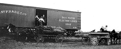 The 1911 advent of the Dan Patch rail line made life easier for Bachman and his sons, all now active in the business. But the railroad did not run close to the family’s greenhouses, so Henry went to Richfield’s village board and received permission to lay track across Lyndale Avenue. This short spur put freight cars right where they were needed.
Richfield market gardeners took advantage of new technology, and using their own ingenuity joined the march of progress. Henry Bachman continued to modernize his produce gardening operation both at the production and distribution levels. Bachman and Parker Goodspeed managed to get Dan Patch rail line stops built adjacent to their land.
Bachman methodically expanded his vegetable and garden business. Henry bought 10 acres (40,468.6 m²) of land each time his wife Hetty delivered a child. The births of sons Fred, Arthur, and Walter in the late 1880s resulted in enough land to handle Bachman’s first ten greenhouses. By 1900 they had eight children, along with a fifteen-room house to hold their family. Henry also now had 150 hotbeds miniature topsoil gardens started in early spring, heated by a watered manure base, and covered with glass window-like sashes for moisture retention. He built the greenhouses on sunny south slopes that also allowed the coal-fired steam heat to rise uphill naturally. Steam condensed to water and returned by gravity to repeat the process. To keep up with Minnesota’s unpredictably cold weather, Bachman, at one time, employed sixteen horses to haul coal to fuel his heaters.
The market garden business boomed, and the five Bachman sons assumed more responsibility. To start them in the business, Henry gave each his own greenhouse bench and allowed them to grow whatever they wished. All except Albert grew vegetables. Influenced by Hattie’s love of flowers, young Albert planted carnations and sold them outside Oak Hill Cemetery. In the 1920s, when the market gardening business started to decline, Bachman’s shifted emphasis to flower production.
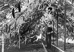 Richfield’s market gardeners grew a wide variety of produce. In this photo, cucumbers reached to the ceiling in a Bachman greenhouse. Henry Bachman built a spur line to the Dan Patch railroad that reached his greenhouses. Frederick Busch continued to expand his business while helping nephews Henry Bachman and William Busch build theirs. Fred Busch developed markets for produce on the northern plains and assisted Richfield and other Twin City-area vegetable wholesalers to surpass Chicago as a shipping point. Meanwhile, as the new century neared, Henry Bachman’s area “under glass” eclipsed in size that of his Uncle Fred. Nonetheless, Northrup, King & Co.
, an emerging power in the seed production industry, featured Fred Busch in a January 1897 advertisement in The Market Garden. A photo showed Busch and one of his greenhouses, while the ad text labeled him one of the area’s “largest growers.”
Fred Busch helped his German-born nephew, William Busch, start his own gardening operation in Richfield. Fourteen-year-old William had arrived in 1880 and learned English in local schools. He married newly arrived German immigrant Helena Bloss in 1891. The young couple soon started their own gardening business on land purchased from Richfield pioneers Dennison and Miriam Townsend. Their land at Penn Avenue, just north of the present-day Crosstown Highway, was adjacent to August Cornelius’s four-thousand-square-foot greenhouse, famous for its hothouse tomatoes, cucumbers, lettuce and assorted produce. When Cornelius’s daughter Johanna married Greenhouses, including this one on the Christ Eisele farm at 64th Street South and Lyndale, dotted the Richfield landscape. By the early 1920s, the village had “about 300000 feet (91,440 m) under glass.”
J. Emil Wagner, another name was added to the Richfield gardening center lexicon. Today, Wagner Greenhouses operates from the original Cornelius base and, like the Bachman garden and florist enterprise, is more than one hundred years old.
Smaller independent farmers also went into produce gardening. Art Hohag remembered a potato planter as his first piece of farm equipment; then came a digger and sprayer. “We would get between $2.50 to $3.00 per ton for the cabbage...and 75 cents a crate (24 quarts) for strawberries.” Potatoes brought 15 cents per bushel. Although prices were low, Hohag recalled, everything cost less. “You could get a schooner of beer for a dime and free meal to go with it.”
Housing developers began nibbling at Richfield’s farm country as the nineteenth century closed. New customers expected to distance themselves from a Minneapolis beset by political corruption
, industrial pollution, and increasing numbers of immigrants. The reputation of Minneapolis had taken a heavy hit in 1902. Lincoln Steffens, a leader among reform-minded writer/reporters known as the “muckrakers,” exposed it as one America’s “worst governed” cities in a McClure’s Magazine article, “The Shame of Minneapolis.”Steffens also wrote extensively about government malfeasance in New York City, Philadelphia, Chicago, and St. Louis. The bad publicity of the era did not create a stampede out of these large urban centers, but more people sought sanctuary in peaceful neighborhoods far from downtown.
Builders in Richfield gave particular attention to lots near lakes and the last remaining land that bordered Minnehaha Creek. Land close to Minnehaha Falls
proved an attractive target to buyers. They snapped up sites in its subdivisions, including the Fourth Addition in the town’s northeast corner bordering Franklin Steele’s original estate. The smaller Minnehaha Heights development to the east of Lake Amelia (later Lake Nokomis
), the Mortimer Addition on the Minneapolis border at 54th and Lyndale, and developments to the west of Diamond Lake
were complete by 1900.
Even before the war’s end, a relaxation of the strict limits on building led some Richfield contractors back to their blueprints. The village issued thirty-one building permits in September 1944.
In June 1945, with war now ended in Europe and winding down in Asia, the Richfield News reported the “partial release” of building materials for the home front which proclaimed, “Richfield is starting to revert back to pre-war building activity.”
In June 1944 Congress had passed the GI Bill of Rights designed to help returning veterans restart their lives. One such benefit affected Richfield directly. The GI Bill subsidized veterans’ mortgages helping them to buy their own housing. By December 1945 the military discharged about 1.25 million men each month. The nation needed five million houses immediately, but almost no homes were available. In Richfield and other suburbs a new kind of American army, a legion of house builders, put up modest, single-family dwellings to combat the housing shortage. Richfield became a Minnesota model for suburban growth.
The stunning growth of Richfield and similar American suburbs was changing the face of America. These flourishing communities were coming into their own as the peacetime economy gathered momentum, spurred, in no small part, by suburban home construction. Young families signed up for houses in once distant farm fields as fast as builders could nail them together.
Between 1940 and 1950, Richfield experienced a population increase of 363 percent. During the following five year period the city nearly doubled its populace again, pushing toward a total of thirty-five thousand. Already ranked as Minnesota’s sixth largest community, there was no question the booming suburb would surpass forty thousand residents by the end of the decade.
Richfield held the unofficial title of Minnesota’s “fastest growing community,” the most prominent among those suburbs growing up around Minneapolis and St. Paul. During the 1950s, America’s suburban population grew at a rate three times faster than that of central cities. Suburbanites made up just over one-quarter of the population in the nation’s metropolitan areas in 1950. Ten years later, about half of metro area residents lived in the suburbs.
Richfield’s farm fields filled with homes during the twenty-five years following World War II. By 1970 all developable land in the community was taken.
Home construction crews applied the “mass-production” systems perfected by the American auto industry. Marlin Grant began his career in construction as a Richfield carpenter and saw the home building process as “fun.” Local builders used just two or three basic house designs, so Grant and his colleagues carried blueprints in their heads. As one writer noted of suburban builders, "it was not the assembly line that moved but the workers.
The people of Richfield embraced their city’s reputation as a “bedroom community” and used that term in describing it. They made a conscious decision to build few sidewalks in the village, readily adopting the prevailing suburban notion that streets were enough. “We wanted people to know that when they cross 62 (the Crosstown Highway border) they weren’t in Minneapolis anymore,” said a proud citizen of more than five decades.
Richfield, Minnesota
As of the census of 2000, there were 34,439 people, 15,073 households, and 8,727 families residing in the city. The population density was 4,993.9 people per square mile . There were 15,357 housing units at an average density of 2,226.9 per square mile...
, is a city in eastern Minnesota
Minnesota
Minnesota is a U.S. state located in the Midwestern United States. The twelfth largest state of the U.S., it is the twenty-first most populous, with 5.3 million residents. Minnesota was carved out of the eastern half of the Minnesota Territory and admitted to the Union as the thirty-second state...
. It is a part of the Minneapolis metro area.
Early Richfield
While it is true that Richfield ranks as the state’s preeminent suburban postwar boomtown, there is much more to the community's story than houses. Its citizens trace the origins of their town to the 1820s and some small settlements, Minnesota’s first “suburbs,” around Fort Snelling.By the late 1830s, the fortress served as a destination for newcomers—lumbermen, missionaries, farmers, traders and travelers—migrating to the borderlands people were now calling “Minisota.”
Fort Snelling’s garrison made up the bulk of the area’s population, along with Henry Sibley and Alexander Faribault’s seventy-five person American Fur Company operation. The federal government licensed American Fur to locate its base at Mendota
Mendota, Minnesota
Mendota is a city in Dakota County, Minnesota, United States. The name comes from the Dakota word for "where the waters meet." The population was 198 at the 2010 census.-History:...
, across the Mississippi
Mississippi River
The Mississippi River is the largest river system in North America. Flowing entirely in the United States, this river rises in western Minnesota and meanders slowly southwards for to the Mississippi River Delta at the Gulf of Mexico. With its many tributaries, the Mississippi's watershed drains...
from the fort. Meanwhile, small settlements of traders, farmers, missionaries and refugees began to develop outside the walls of the fort, some with permission, some without. These residents built communities on land that would become known as Richfield.
Richfield Township is established
The Territory of Minnesota got approval to become, on May 11, 1858, the thirty second state in the union. On that same day citizens of Minnesota’s newly established town of Richland met in a schoolhouse near Richland Mills, at present-day 53rd and Lyndale, to form a government. At that first meeting of the town electors, those who previously referred to themselves as living in Harmony or Richland Mills chose the name of Richfield for their community.The forty citizens in attendance at the organizational meeting selected Riley Bartholomew
Riley Bartholomew
Riley Bartholomew was a Minnesota state senator from 1859 to 1860.Riley Bartholomew married Fanny A. Watkins in 1829. He became a merchant in Geneva, Ohio, selling clocks and later operating a hotel before the family moved to Jefferson, Ohio, the Ashtabula County seat. In 1848 he was elected sheriff...
temporary chairman of the meeting, with Asa Keith moderator, and Alonzo Sawtelle clerk. Voters elected George Odell assessor, James Dunsmoor overseer of the poor, George W. Townsend and William Moffett constables, and George Irwin and Bartholomew as justices of the peace. William Finch was elected to the Hennepin County Board of Commissioners. Minutes of the town’s 1858 organizational meeting at Richland’s mill school show voters decided the community would “be hereafter known by the name of Richfield.”
Richfield taxpayers budgeted four hundred dollars for expenses and added a twenty-five-cent tax on every one hundred dollars of real estate for road improvement. Richland Mills, later known as Richfield Mills, became the de facto town and business center. The Harmony post office, south of the mill on today’s Lyndale Avenue, opened in 1854. Postmaster James Dunsmoor named the mail center after his hometown in Maine.
Other businesses, including a blacksmith shop and meat market, clustered around the mill at this town hub. Small and scattered farms dotted the Richfield landscape.
The fields of Richfield proved bountiful for the settlers. Early crops included corn, wheat and oats. Wheat immediately became the “cash” crop, sold in the area’s first major market, St. Paul
Saint Paul, Minnesota
Saint Paul is the capital and second-most populous city of the U.S. state of Minnesota. The city lies mostly on the east bank of the Mississippi River in the area surrounding its point of confluence with the Minnesota River, and adjoins Minneapolis, the state's largest city...
. Those in the southern parts of Hennepin County found it more profitable to haul their wheat crop to St. Paul than to the St. Anthony Falls district. This occurred in the days before “King Wheat” and the evolution of Minneapolis into a milling center. In 1860 H. H. Hopkins of Richfield wrote to Minnesota Farmer and Gardener claiming he was getting a good yield of twenty-seven bushels of wheat per acre while handling the threshing himself. His oat yield varied from forty to seventy-five bushels per acre.
Settlers from Maine
Maine
Maine is a state in the New England region of the northeastern United States, bordered by the Atlantic Ocean to the east and south, New Hampshire to the west, and the Canadian provinces of Quebec to the northwest and New Brunswick to the northeast. Maine is both the northernmost and easternmost...
made up 35 percent of the total number of U.S.-born adults (eighteen years old or older) in 1860 Richfield. New York immigrants, at 21 percent, were a notable but distant second. Maine’s 120 and New York’s 74 adults made up more than half the American-born newcomers in the town. Fifty-eight immigrants from Ireland
Ireland
Ireland is an island to the northwest of continental Europe. It is the third-largest island in Europe and the twentieth-largest island on Earth...
represented just under half of the 119 adults from other nations. Just three of Richfield’s citizens had been born in Minnesota.
Bloomington, Minnesota
Bloomington is the fifth largest city in the U.S. state of Minnesota in Hennepin County. Located on the north bank of the Minnesota River above its confluence with the Mississippi River, Bloomington lies at the heart of the southern...
and Eden Prairie
Eden Prairie, Minnesota
As of the census of 2000, there were 54,901 people, 20,457 households, and 14,579 families residing in the city. The population density was . There were 21,026 housing units at an average density of 649.2 per square mile...
. Electors of the newly created Richland met on May 11, 1858, and changed the name of their town to Richfield.
The boundaries of Richfield included all of congressional township 28 Range 24 and parts of adjoining townships, which together contained about sixty-three square miles. Richfield originally ranged to Minneapolis’s Lake Street on the north, to what is now Highway 169 on the west, to Bloomington on the south, and to Fort Snelling and the Minnesota and Mississippi rivers on the east.
Parts of Richfield were later lost to neighboring towns or villages through annexation. An 1886 partition of Richfield created the village of St. Louis Park, and a later division approved April 5, 1889, produced the village of Edina. Minneapolis absorbed sizeable portions of Richfield territory through legislative action or annexations in 1867, 1883, 1887 and 1927. The growth of Twin Cities International Airport during the last half of the twentieth century and addition of land to the Fort Snelling compound meant further reductions.
These border changes have an effect on the telling of Richfield’s history. Some significant sites in state and local history once located in the community are no longer within its boundaries. For example, the site of Richfield Mills, the township’s original business and political center, is now in Minneapolis at Lyndale Avenue and Minnehaha Creek. Places such as Lake Calhoun, Lake Harriet and Minnehaha Falls once were part of Richfield.
The "City" of Fort Snelling
Minnesotan Franklin SteeleFranklin Steele
Franklin Steele was an early and significant settler of Minneapolis, Minnesota in the United States. Born in Chester County, Pennsylvania of Scottish descent, Steele worked in the Lancaster post-office as a young man, where he once met James Buchanan.-Early success:With encouragement from his...
first reached Fort Snelling in 1837 where he worked as a sutler, selling goods to soldiers. By the time of his outing with Mayer, Steele had branched out into lumbering and merchandising. While the artist Mayer marveled at the beauty of the rolling prairies of the future Richfield, Frank Steele saw farmland platted, subdivided, and easily sold to settlers—hopefully by him. Steele deduced that much of the Fort Snelling reservation would be sold by the government for development and was already working on a plan to acquire a substantial portion of the land.
In April 1856 Steele offered to pay the U.S. government fifteen dollars per acre for the entire Snelling reservation. Jefferson Davis, secretary of war, turned down the bid, but his “no” hardly discouraged the determined Minnesotan. After Steele orchestrated a complicated series of deft political moves in Washington D.C., the government agreed to sell him roughly 8000 acres (32.4 km²) for $90,000 on a contract for deed. The clever Frank Steele, with some financial support from several New York insiders, had outmaneuvered Minnesota rivals who cultivated their own schemes for acquiring fort lands.
The ambitious Steele, eager to turn a profit for himself and his backers, had managed to survey about 640 acres (2.6 km²) of the newly acquired land just prior to the great nationwide financial collapse of 1857. He named his development City of Fort Snelling and published a map showing the new community’s layout. The economic downturn halted work on the first housing subdivision of what would become Richfield.
Market gardening industry founded
Several innovative agriculturalists founded the community’s market gardening industryMarket gardening
A market garden is the relatively small-scale production of fruits, vegetables and flowers as cash crops, frequently sold directly to consumers and restaurants. It is distinguishable from other types of farming by the diversity of crops grown on a small area of land, typically, from under one acre ...
in the 1870s and 1880s—Richfield’s trademark for the coming century.
In 1885 Hattie and Henry Bachman bought 4 acres (16,187.4 m²) near 61st and Lyndale, close to the Minneapolis border, and started their own business. Using money Hattie earned as a seamstress, they bought horses to clear the land and, that spring, planted potatoes, lettuce, onions and squash.
South Minneapolis was almost fully subdivided as the twentieth century approached. Richfield farmers, in many cases by descendants of early settlers, still occupied most of the town’s land.
The remarkable growth of Minneapolis
Minneapolis, Minnesota
Minneapolis , nicknamed "City of Lakes" and the "Mill City," is the county seat of Hennepin County, the largest city in the U.S. state of Minnesota, and the 48th largest in the United States...
directly affected Richfield produce farmers. Minneapolis quadrupled in size between 1880 and 1895 to 192,833, surpassing St. Paul by more than fifty thousand people. Richfield farmers looked on the metropolis to its north as their marketing target. They helped supply its restaurants, hotels, grocers and citizens with fresh produce, with enough left over to ship by railroad to other cities.
Minneapolis became a favorite trading point for market gardeners in 1897 with the building of the modern, covered Second Street Market just two blocks west of Hennepin Avenue
Hennepin Avenue
Hennepin Avenue is a major street in Minneapolis, Minnesota, United States. It runs from Lakewood Cemetery , north through the Uptown District of Southwest Minneapolis, through the former "Bottleneck" area west of Loring Park, through the North Loop in the city center, to Northeast Minneapolis and...
and Bridge Square. The market featured a massive platform for gardeners, including Richfield’s sizeable contingent, to unload and display produce. The new system freedstreets from traffic snarls by allowing each person to unhitch and put up their horses, while their wagon was backed into an assigned space. Wholesale customers could then bring their teams to the platform and start negotiating prices when the starting bell sounded.
Richfield market gardeners took advantage of new technology, and using their own ingenuity joined the march of progress. Henry Bachman continued to modernize his produce gardening operation both at the production and distribution levels. Bachman and Parker Goodspeed managed to get Dan Patch rail line stops built adjacent to their land.
Bachman methodically expanded his vegetable and garden business. Henry bought 10 acres (40,468.6 m²) of land each time his wife Hetty delivered a child. The births of sons Fred, Arthur, and Walter in the late 1880s resulted in enough land to handle Bachman’s first ten greenhouses. By 1900 they had eight children, along with a fifteen-room house to hold their family. Henry also now had 150 hotbeds miniature topsoil gardens started in early spring, heated by a watered manure base, and covered with glass window-like sashes for moisture retention. He built the greenhouses on sunny south slopes that also allowed the coal-fired steam heat to rise uphill naturally. Steam condensed to water and returned by gravity to repeat the process. To keep up with Minnesota’s unpredictably cold weather, Bachman, at one time, employed sixteen horses to haul coal to fuel his heaters.
The market garden business boomed, and the five Bachman sons assumed more responsibility. To start them in the business, Henry gave each his own greenhouse bench and allowed them to grow whatever they wished. All except Albert grew vegetables. Influenced by Hattie’s love of flowers, young Albert planted carnations and sold them outside Oak Hill Cemetery. In the 1920s, when the market gardening business started to decline, Bachman’s shifted emphasis to flower production.
Northrup-King
Northrup-King Seed Company was founded in Minneapolis, Minnesota in 1896, and was based in Minneapolis until it was acquired and moved to Golden Valley, Minnesota in 1986. It is now a division of Syngenta....
, an emerging power in the seed production industry, featured Fred Busch in a January 1897 advertisement in The Market Garden. A photo showed Busch and one of his greenhouses, while the ad text labeled him one of the area’s “largest growers.”
Fred Busch helped his German-born nephew, William Busch, start his own gardening operation in Richfield. Fourteen-year-old William had arrived in 1880 and learned English in local schools. He married newly arrived German immigrant Helena Bloss in 1891. The young couple soon started their own gardening business on land purchased from Richfield pioneers Dennison and Miriam Townsend. Their land at Penn Avenue, just north of the present-day Crosstown Highway, was adjacent to August Cornelius’s four-thousand-square-foot greenhouse, famous for its hothouse tomatoes, cucumbers, lettuce and assorted produce. When Cornelius’s daughter Johanna married Greenhouses, including this one on the Christ Eisele farm at 64th Street South and Lyndale, dotted the Richfield landscape. By the early 1920s, the village had “about 300000 feet (91,440 m) under glass.”
J. Emil Wagner, another name was added to the Richfield gardening center lexicon. Today, Wagner Greenhouses operates from the original Cornelius base and, like the Bachman garden and florist enterprise, is more than one hundred years old.
Smaller independent farmers also went into produce gardening. Art Hohag remembered a potato planter as his first piece of farm equipment; then came a digger and sprayer. “We would get between $2.50 to $3.00 per ton for the cabbage...and 75 cents a crate (24 quarts) for strawberries.” Potatoes brought 15 cents per bushel. Although prices were low, Hohag recalled, everything cost less. “You could get a schooner of beer for a dime and free meal to go with it.”
The encroachment of Minneapolis
To Richfield residents, their homes were in “farm country.” A salesman selling real estate approached Richard Herman and his father in the early 1920s while they milked cows on their 77th and Lyndale farm. The seller offered the senior Herman a deal on one entire corner, 10 acres (40,468.6 m²), of the intersection at Lyndale and 66th. But this major crossroad of the future did not interest Herman. It was, he said, “too far away to pasture and too rough for plowing.”Housing developers began nibbling at Richfield’s farm country as the nineteenth century closed. New customers expected to distance themselves from a Minneapolis beset by political corruption
Political corruption
Political corruption is the use of legislated powers by government officials for illegitimate private gain. Misuse of government power for other purposes, such as repression of political opponents and general police brutality, is not considered political corruption. Neither are illegal acts by...
, industrial pollution, and increasing numbers of immigrants. The reputation of Minneapolis had taken a heavy hit in 1902. Lincoln Steffens, a leader among reform-minded writer/reporters known as the “muckrakers,” exposed it as one America’s “worst governed” cities in a McClure’s Magazine article, “The Shame of Minneapolis.”Steffens also wrote extensively about government malfeasance in New York City, Philadelphia, Chicago, and St. Louis. The bad publicity of the era did not create a stampede out of these large urban centers, but more people sought sanctuary in peaceful neighborhoods far from downtown.
Builders in Richfield gave particular attention to lots near lakes and the last remaining land that bordered Minnehaha Creek. Land close to Minnehaha Falls
Minnehaha Falls
Minnehaha Creek is a tributary of the Mississippi River located in Hennepin County, Minnesota that extends from Lake Minnetonka in the west and flows east for 22 miles through several suburbs west of Minneapolis and then through south Minneapolis. Including Lake Minnetonka, the watershed for the...
proved an attractive target to buyers. They snapped up sites in its subdivisions, including the Fourth Addition in the town’s northeast corner bordering Franklin Steele’s original estate. The smaller Minnehaha Heights development to the east of Lake Amelia (later Lake Nokomis
Lake Nokomis
Lake Nokomis is one of several lakes in Minneapolis, Minnesota. The lake was originally named Lake Amelia in honor of Captain George Gooding’s daughter, Amelia, in 1819. Its current name was adopted in 1910 to honor Nokomis, grandmother of Hiawatha...
), the Mortimer Addition on the Minneapolis border at 54th and Lyndale, and developments to the west of Diamond Lake
Diamond Lake
-U.S. geographical locations:*Diamond Lake, Minneapolis, a neighborhood in the Nokomis community in Minneapolis*Diamond Lake , a lake in the southern part of the U.S...
were complete by 1900.
Post World War II Suburban Development
Disturbing infrastructure issues critical to the village’s future confronted the people of postwar Richfield. The village lacked classroom space and a senior high school, it had no movie theater, no bowling alley, no baseball or football field, no swimming beach, it had no city water supply or storm and sanitary sewer systems, and it faced loss of land due to expansion of the airport. World war had shoved all these problems into the background, but they were now back and more pressing than ever, it Richfield did have a new municipal liquor store and it was doing very well, producing nearly twelve thousand dollars in its first ten months of operation. Village leaders came to depend upon this money for postwar civic projects.Even before the war’s end, a relaxation of the strict limits on building led some Richfield contractors back to their blueprints. The village issued thirty-one building permits in September 1944.
In June 1945, with war now ended in Europe and winding down in Asia, the Richfield News reported the “partial release” of building materials for the home front which proclaimed, “Richfield is starting to revert back to pre-war building activity.”
In June 1944 Congress had passed the GI Bill of Rights designed to help returning veterans restart their lives. One such benefit affected Richfield directly. The GI Bill subsidized veterans’ mortgages helping them to buy their own housing. By December 1945 the military discharged about 1.25 million men each month. The nation needed five million houses immediately, but almost no homes were available. In Richfield and other suburbs a new kind of American army, a legion of house builders, put up modest, single-family dwellings to combat the housing shortage. Richfield became a Minnesota model for suburban growth.
The stunning growth of Richfield and similar American suburbs was changing the face of America. These flourishing communities were coming into their own as the peacetime economy gathered momentum, spurred, in no small part, by suburban home construction. Young families signed up for houses in once distant farm fields as fast as builders could nail them together.
Between 1940 and 1950, Richfield experienced a population increase of 363 percent. During the following five year period the city nearly doubled its populace again, pushing toward a total of thirty-five thousand. Already ranked as Minnesota’s sixth largest community, there was no question the booming suburb would surpass forty thousand residents by the end of the decade.
Richfield held the unofficial title of Minnesota’s “fastest growing community,” the most prominent among those suburbs growing up around Minneapolis and St. Paul. During the 1950s, America’s suburban population grew at a rate three times faster than that of central cities. Suburbanites made up just over one-quarter of the population in the nation’s metropolitan areas in 1950. Ten years later, about half of metro area residents lived in the suburbs.
Richfield’s farm fields filled with homes during the twenty-five years following World War II. By 1970 all developable land in the community was taken.
Home construction crews applied the “mass-production” systems perfected by the American auto industry. Marlin Grant began his career in construction as a Richfield carpenter and saw the home building process as “fun.” Local builders used just two or three basic house designs, so Grant and his colleagues carried blueprints in their heads. As one writer noted of suburban builders, "it was not the assembly line that moved but the workers.
The people of Richfield embraced their city’s reputation as a “bedroom community” and used that term in describing it. They made a conscious decision to build few sidewalks in the village, readily adopting the prevailing suburban notion that streets were enough. “We wanted people to know that when they cross 62 (the Crosstown Highway border) they weren’t in Minneapolis anymore,” said a proud citizen of more than five decades.