
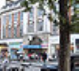
High Street Kensington tube station
Encyclopedia
High Street Kensington is a London Underground
station at Kensington High Street
.
The station is on the Circle Line between Gloucester Road
and Notting Hill Gate
, and the District Line
between Earl's Court
and Notting Hill Gate
. It is in Travelcard Zone 1
.
The station complex incorporates retail stores (including a Marks & Spencer
and a Pret a Manger
). The station itself has four platforms - two through platforms and two bay platform
s. Platform 1 is used for anti-clockwise Circle Line and westbound District Line
line trains towards Gloucester Road
and Earl's Court
, respectively. Platform 2 is for clockwise Circle Line and eastbound District Line
trains towards Edgware Road
. Platforms 3 and 4 are used for terminating District Line
trains from Earl's Court
. Platform 3 is usually used for the Olympia service and platform 4 is usually only used at the start and end of the day. There used to be a waiting room between Platform 2 & 3 for customer use, but this was turned into a staff room for drivers shortly before the Circle Line Hammersmith Extension was implemented in December 2009.
Just south of the station is the junction where the Circle and District
lines diverge.
The typical off-peak service from this station is:
London Underground
The London Underground is a rapid transit system serving a large part of Greater London and some parts of Buckinghamshire, Hertfordshire and Essex in England...
station at Kensington High Street
Kensington High Street
Kensington High Street is the main shopping street in Kensington, west London. The area is identified in the London Plan as one of 35 major centres in Greater London....
.
The station is on the Circle Line between Gloucester Road
Gloucester Road tube station
-Deep-level station:By the beginning of the 20th century, the MDR had been extended to Richmond, Ealing Broadway, Hounslow West and Wimbledon in the west and to New Cross Gate in the east...
and Notting Hill Gate
Notting Hill Gate tube station
Notting Hill Gate tube station is a London Underground station in the street known as Notting Hill Gate. On the Central Line, it is between Holland Park to the west and Queensway to the east. On the District Line and Circle Line it is between High Street Kensington and Bayswater stations...
, and the District Line
District Line
The District line is a line of the London Underground, coloured green on the Tube map. It is a "sub-surface" line, running through the central area in shallow cut-and-cover tunnels. It is the busiest of the sub-surface lines. Out of the 60 stations served, 25 are underground...
between Earl's Court
Earl's Court tube station
Earl's Court tube station is a London Underground station in Earls Court. The station is located between Earls Court Road and Warwick Road . It is on the boundary of Travelcard Zone 1 and 2 and is in both zones....
and Notting Hill Gate
Notting Hill Gate tube station
Notting Hill Gate tube station is a London Underground station in the street known as Notting Hill Gate. On the Central Line, it is between Holland Park to the west and Queensway to the east. On the District Line and Circle Line it is between High Street Kensington and Bayswater stations...
. It is in Travelcard Zone 1
Travelcard Zone 1
Fare zone 1 is the central zone of Transport for London's zonal fare system used for calculating the price of tickets for travel on the London Underground, London Overground, Docklands Light Railway and, since 2007, on National Rail services. For most tickets, travel through the zone is charged...
.
The station complex incorporates retail stores (including a Marks & Spencer
Marks & Spencer
Marks and Spencer plc is a British retailer headquartered in the City of Westminster, London, with over 700 stores in the United Kingdom and over 300 stores spread across more than 40 countries. It specialises in the selling of clothing and luxury food products...
and a Pret a Manger
Pret A Manger
Pret a Manger is a British sandwich retail chain based in the City of Westminster, London, United Kingdom. The name "Pret a Manger" comes from the French prêt à manger, meaning "ready to eat", a reference to prêt-à-porter .The company was founded in London in 1986 by friends Sinclair Beecham and...
). The station itself has four platforms - two through platforms and two bay platform
Bay platform
Bay platform is a railway-related term commonly used in the UK and Australia to describe a dead-end platform at a railway station that has through lines...
s. Platform 1 is used for anti-clockwise Circle Line and westbound District Line
District Line
The District line is a line of the London Underground, coloured green on the Tube map. It is a "sub-surface" line, running through the central area in shallow cut-and-cover tunnels. It is the busiest of the sub-surface lines. Out of the 60 stations served, 25 are underground...
line trains towards Gloucester Road
Gloucester Road tube station
-Deep-level station:By the beginning of the 20th century, the MDR had been extended to Richmond, Ealing Broadway, Hounslow West and Wimbledon in the west and to New Cross Gate in the east...
and Earl's Court
Earl's Court tube station
Earl's Court tube station is a London Underground station in Earls Court. The station is located between Earls Court Road and Warwick Road . It is on the boundary of Travelcard Zone 1 and 2 and is in both zones....
, respectively. Platform 2 is for clockwise Circle Line and eastbound District Line
District Line
The District line is a line of the London Underground, coloured green on the Tube map. It is a "sub-surface" line, running through the central area in shallow cut-and-cover tunnels. It is the busiest of the sub-surface lines. Out of the 60 stations served, 25 are underground...
trains towards Edgware Road
Edgware Road tube station
Edgware Road station is a London Underground station on the corner of Chapel Street and Cabbell Street Road in Travelcard Zone 1 serving the Circle, District and Hammersmith & City lines. The separate Edgware Road tube station is about 150 metres away on the opposite side of the Marylebone Road...
. Platforms 3 and 4 are used for terminating District Line
District Line
The District line is a line of the London Underground, coloured green on the Tube map. It is a "sub-surface" line, running through the central area in shallow cut-and-cover tunnels. It is the busiest of the sub-surface lines. Out of the 60 stations served, 25 are underground...
trains from Earl's Court
Earl's Court tube station
Earl's Court tube station is a London Underground station in Earls Court. The station is located between Earls Court Road and Warwick Road . It is on the boundary of Travelcard Zone 1 and 2 and is in both zones....
. Platform 3 is usually used for the Olympia service and platform 4 is usually only used at the start and end of the day. There used to be a waiting room between Platform 2 & 3 for customer use, but this was turned into a staff room for drivers shortly before the Circle Line Hammersmith Extension was implemented in December 2009.
Just south of the station is the junction where the Circle and District
District Line
The District line is a line of the London Underground, coloured green on the Tube map. It is a "sub-surface" line, running through the central area in shallow cut-and-cover tunnels. It is the busiest of the sub-surface lines. Out of the 60 stations served, 25 are underground...
lines diverge.
The typical off-peak service from this station is:
- 14 tph (trains per hour) to Edgware RoadEdgware Road tube stationEdgware Road station is a London Underground station on the corner of Chapel Street and Cabbell Street Road in Travelcard Zone 1 serving the Circle, District and Hammersmith & City lines. The separate Edgware Road tube station is about 150 metres away on the opposite side of the Marylebone Road...
via PaddingtonPaddington stationPaddington railway station, also known as London Paddington, is a central London railway terminus and London Underground complex.The site is a historic one, having served as the London terminus of the Great Western Railway and its successors since 1838. Much of the current mainline station dates...
(6 tph District lineDistrict LineThe District line is a line of the London Underground, coloured green on the Tube map. It is a "sub-surface" line, running through the central area in shallow cut-and-cover tunnels. It is the busiest of the sub-surface lines. Out of the 60 stations served, 25 are underground...
, 8 tph Circle Line) - 6 tph to WimbledonWimbledon stationWimbledon station is a National Rail, London Underground, and Tramlink station located in Wimbledon in the London Borough of Merton, and is the only London station that provides an interchange between rail, Underground, and Tramlink services...
via Earl's CourtEarl's Court tube stationEarl's Court tube station is a London Underground station in Earls Court. The station is located between Earls Court Road and Warwick Road . It is on the boundary of Travelcard Zone 1 and 2 and is in both zones....
(District lineDistrict LineThe District line is a line of the London Underground, coloured green on the Tube map. It is a "sub-surface" line, running through the central area in shallow cut-and-cover tunnels. It is the busiest of the sub-surface lines. Out of the 60 stations served, 25 are underground...
) - 3 tph to Kensington (Olympia)Kensington (Olympia) stationKensington station is a station in West London managed and served by London Overground and also served by Southern and London Underground. It is in Travelcard Zone 2...
via Earl's CourtEarl's Court tube stationEarl's Court tube station is a London Underground station in Earls Court. The station is located between Earls Court Road and Warwick Road . It is on the boundary of Travelcard Zone 1 and 2 and is in both zones....
(District lineDistrict LineThe District line is a line of the London Underground, coloured green on the Tube map. It is a "sub-surface" line, running through the central area in shallow cut-and-cover tunnels. It is the busiest of the sub-surface lines. Out of the 60 stations served, 25 are underground...
) - 8 tph anticlockwise on the Circle line via Victoria and EmbankmentEmbankment tube stationEmbankment is a London Underground station in the City of Westminster, known by various names during its history. It is served by the Circle, District, Northern and Bakerloo lines. On the Northern and Bakerloo lines, the station is between Waterloo and Charing Cross stations; on the Circle and...
to Hammersmith