Havasupai Trail
Encyclopedia
Supai, Arizona
Supai is a census-designated place in Coconino County, Arizona, United States, within the Grand Canyon.As of the 1990 census, the CDP had a population of 423; the 2000 census erroneously recorded a population of 0...
and to Havasu Falls.
Trail
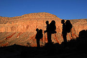
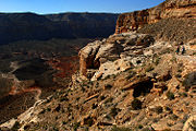
The trailhead is located at Hualapai HilltopHualapai Hilltop, Arizona
Hualapai Hilltop is the location of the trailhead that leads down into Supai, Arizona. At some point in the past, the rim area was inhabited by the Havasupai people, who moved seasonally between the canyon floor and the rim, but they were forced to stay in the canyon by the Bureau of Indian...
(which is located at the end of BIA Road 18), where there is a large parking lot, a heli-pad, portable toilets, and the main office for the Havasupai. The trail can be traveled by foot, by horseback, or on a mule service the Havasupai offer. The mule service can also be purchased for luggage/packs only, which allows an easier hike and the ability to bring down more luxuries. The trail starts out at the hilltop, where it switch-backs down the side of the canyon for about ¾ of a mile. This is by far the most difficult part of the trail, and is much more difficult on the way back up. The trail is approximately 8 miles (12.9 km) long to Supai, with an extra 2 miles (3.2 km) added on in order to reach the campgrounds, and descends some 3000 vertical feet (914 meters).
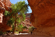
The trail will take you next to the stream where you will encounter a bridge. The trail crosses the bridge, thus entering into the town of Supai. Stay on the trail and respect the fences as the land behind them is private property. The trail enters into the city main, where it first encounters a small convenience shop that sells drinks, ice cream, candy, food, and other snacks. Straight ahead lies a rodeo corral where there are usually bulls penned-up. The trail leads to the town square where all the public buildings are located. The trail then goes through the city along the canyon wall to the right. The trail makes an obvious right-hand turn and enters into more vegetation. After leaving the vegetation the trail follows the canyon to the left.