
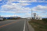
Hartsel, Colorado
Encyclopedia
Hartsel is an unincorporated town
and a U.S. Post Office
located in Park County
, Colorado
, United States
. Hartsel was founded in 1880. Located at the geographic center of the state, it is often referred to as "The Heart of Colorado". The community's namesake is Samuel Hartsel, a local cattle rancher. The Hartsel Post Office has the ZIP Code
80449. The ZCTA
for 80449 had a population of 677 at the 2000 census
.
According to the United States Census Bureau
the town has a total area of 605.10 square miles (973.60 km²), 601.18 square miles (967.29 km²) is land and 3.92 square miles (6.30 km²) is covered with water. Hartsel's elevation is 2,702 meters (8,864 feet).
of 2000, the population of ZIP code 80449 was 677 with 284 households. The population density
was 1.13 per square mile (1.81 per km²). The racial makeup of the ZIP code was 94.1% White, 0.9% Native American, 2.7% other races, and 2.4% from two or more races.
Unincorporated area
In law, an unincorporated area is a region of land that is not a part of any municipality.To "incorporate" in this context means to form a municipal corporation, a city, town, or village with its own government. An unincorporated community is usually not subject to or taxed by a municipal government...
and a U.S. Post Office
United States Postal Service
The United States Postal Service is an independent agency of the United States government responsible for providing postal service in the United States...
located in Park County
Park County, Colorado
Park County is the 17th most extensive of the 64 counties of the State of Colorado of the United States. The county was named after the large geographic region known as South Park, which was named by early fur traders and trappers in the area. The geographic center of the State of Colorado is...
, Colorado
Colorado
Colorado is a U.S. state that encompasses much of the Rocky Mountains as well as the northeastern portion of the Colorado Plateau and the western edge of the Great Plains...
, United States
United States
The United States of America is a federal constitutional republic comprising fifty states and a federal district...
. Hartsel was founded in 1880. Located at the geographic center of the state, it is often referred to as "The Heart of Colorado". The community's namesake is Samuel Hartsel, a local cattle rancher. The Hartsel Post Office has the ZIP Code
ZIP Code
ZIP codes are a system of postal codes used by the United States Postal Service since 1963. The term ZIP, an acronym for Zone Improvement Plan, is properly written in capital letters and was chosen to suggest that the mail travels more efficiently, and therefore more quickly, when senders use the...
80449. The ZCTA
ZIP Code Tabulation Area
ZIP Code Tabulation Areas are statistical entities developed by the United States Census Bureau for tabulating summary statistics from Census 2000. This new entity was developed to overcome the difficulties in precisely defining the land area covered by each ZIP code...
for 80449 had a population of 677 at the 2000 census
United States Census, 2000
The Twenty-second United States Census, known as Census 2000 and conducted by the Census Bureau, determined the resident population of the United States on April 1, 2000, to be 281,421,906, an increase of 13.2% over the 248,709,873 persons enumerated during the 1990 Census...
.
Geography
Hartsel is located at 39°01′17"N 105°47′45"W (39.021318,-105.795765).According to the United States Census Bureau
United States Census Bureau
The United States Census Bureau is the government agency that is responsible for the United States Census. It also gathers other national demographic and economic data...
the town has a total area of 605.10 square miles (973.60 km²), 601.18 square miles (967.29 km²) is land and 3.92 square miles (6.30 km²) is covered with water. Hartsel's elevation is 2,702 meters (8,864 feet).
Demographics
As of the censusCensus
A census is the procedure of systematically acquiring and recording information about the members of a given population. It is a regularly occurring and official count of a particular population. The term is used mostly in connection with national population and housing censuses; other common...
of 2000, the population of ZIP code 80449 was 677 with 284 households. The population density
Population density
Population density is a measurement of population per unit area or unit volume. It is frequently applied to living organisms, and particularly to humans...
was 1.13 per square mile (1.81 per km²). The racial makeup of the ZIP code was 94.1% White, 0.9% Native American, 2.7% other races, and 2.4% from two or more races.
External links
- Hartsel Springs Ranch Historic ranch - Indian lookout, herds of buffalo, historic buildings
- Photos of Hartsel
- Hartsel Weather