
Harrold, Bedfordshire
Encyclopedia
Harrold is a civil parish and electoral ward
in the Borough of Bedford within Bedfordshire
, England
, around nine miles north-west of Bedford
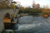
. The village is on the north bank of the River Great Ouse
, and is the site of an ancient bridge, linking the village with Carlton with Chellington
on the south bank. Immediately to the east of the village is Odell
. Across the bridge is Carlton
.
The buttermarket in Harrold has often been an iconic image in Harrold, along with the bridge. It also used to be the logo for one of the schools in Harrold. Harrold also has a village lock-up
that was used to detain drunks and suspected criminals. It is no longer in use.
Two schools exist in the village: Harrold Lower School and Harrold Priory Middle School
.
of 1086 as a parish within the Hundred of Willey
. of the village is Odell
.
An early medieval sword mount was unearthed by a metal detectorist in 2006. It is believed the tiny decoration could have adorned the sword belt of a high-ranking Saxon warrior.
within the Borough of Bedford, is named after Harrold and contains four civil parishes within its boundaries. Parishes and settlements within the ward, from south to north are Harrold parish, Odell
parish, Podington
parish including Hinwick
and Farndish
, and Wymington
parish including Little Wymington. Harrold itself is near the southern boundary of its ward which follows some of the River Great Ouse. The ward extends northward from Harrold and fills the northwest corner of Bedfordshire, bordering Northamptonshire
.
Wards of the United Kingdom
A ward in the United Kingdom is an electoral district at sub-national level represented by one or more councillors. It is the primary unit of British administrative and electoral geography .-England:...
in the Borough of Bedford within Bedfordshire
Bedfordshire
Bedfordshire is a ceremonial county of historic origin in England that forms part of the East of England region.It borders Cambridgeshire to the north-east, Northamptonshire to the north, Buckinghamshire to the west and Hertfordshire to the south-east....
, England
England
England is a country that is part of the United Kingdom. It shares land borders with Scotland to the north and Wales to the west; the Irish Sea is to the north west, the Celtic Sea to the south west, with the North Sea to the east and the English Channel to the south separating it from continental...
, around nine miles north-west of Bedford
Bedford
Bedford is the county town of Bedfordshire, in the East of England. It is a large town and the administrative centre for the wider Borough of Bedford. According to the former Bedfordshire County Council's estimates, the town had a population of 79,190 in mid 2005, with 19,720 in the adjacent town...
. The village is on the north bank of the River Great Ouse
River Great Ouse
The Great Ouse is a river in the east of England. At long, it is the fourth-longest river in the United Kingdom. The river has been important for navigation, and for draining the low-lying region through which it flows. Its course has been modified several times, with the first recorded being in...
, and is the site of an ancient bridge, linking the village with Carlton with Chellington
Carlton with Chellington
Carlton with Chellington is a civil parish in the historical Hundred of Willey in Bedfordshire, England, and is within the Borough of Bedford. The parish is situated on the South bank of the River Great Ouse, from Harrold, and includes the villages of Carlton and Chellington.The two parishes of...
on the south bank. Immediately to the east of the village is Odell
Odell, Bedfordshire
Odell is a village and civil parish in the north of the county of Bedfordshire in England that lies to the north-west of the county town of Bedford, near the villages of Harrold, Felmersham, Sharnbrook, and Carlton.-Roman and Saxon period:...
. Across the bridge is Carlton
Carlton, Bedfordshire
Carlton is a village in the Bedford district of Bedfordshire, England, part of the Carlton with Chellington parish with the adjacent village of Chellington. The River Great Ouse runs just to the north of the village. Nearby places are Harrold, Pavenham, Turvey, Lavendon and Little Odell.Carlton...
.
The buttermarket in Harrold has often been an iconic image in Harrold, along with the bridge. It also used to be the logo for one of the schools in Harrold. Harrold also has a village lock-up
Village lock-up
Village lock-ups are historic buildings that were used for the temporary detention of people in rural parts of England and Wales. They were often used for the confinement of drunks who were usually released the next day or to hold people being brought before the local magistrate. A typical village...
that was used to detain drunks and suspected criminals. It is no longer in use.
Two schools exist in the village: Harrold Lower School and Harrold Priory Middle School
Harrold Priory Middle School
Harrold Priory Middle School, sometimes referred to as HPMS, is a middle school in the village of Harrold, Bedfordshire. It is one of the three main feeder schools to Sharnbrook Upper School, along with Lincroft Middle School and Margaret Beaufort Middle School. It opened in 1937 as Harrold County...
.
History
Harrold was recorded in the Domesday BookDomesday Book
Domesday Book , now held at The National Archives, Kew, Richmond upon Thames in South West London, is the record of the great survey of much of England and parts of Wales completed in 1086...
of 1086 as a parish within the Hundred of Willey
Hundred of Willey
The Hundred of Willey is a historical land division, a hundred in northwest corner of Bedfordshire, England. Its northwestern boundary is the county border with Northamptonshire, and its southwestern boundary the border with Buckinghamshire...
. of the village is Odell
Odell, Bedfordshire
Odell is a village and civil parish in the north of the county of Bedfordshire in England that lies to the north-west of the county town of Bedford, near the villages of Harrold, Felmersham, Sharnbrook, and Carlton.-Roman and Saxon period:...
.
An early medieval sword mount was unearthed by a metal detectorist in 2006. It is believed the tiny decoration could have adorned the sword belt of a high-ranking Saxon warrior.
Electoral ward
Today an electoral wardWards of the United Kingdom
A ward in the United Kingdom is an electoral district at sub-national level represented by one or more councillors. It is the primary unit of British administrative and electoral geography .-England:...
within the Borough of Bedford, is named after Harrold and contains four civil parishes within its boundaries. Parishes and settlements within the ward, from south to north are Harrold parish, Odell
Odell, Bedfordshire
Odell is a village and civil parish in the north of the county of Bedfordshire in England that lies to the north-west of the county town of Bedford, near the villages of Harrold, Felmersham, Sharnbrook, and Carlton.-Roman and Saxon period:...
parish, Podington
Podington
Podington is a village and civil parish in northwest Bedfordshire in England, United Kingdom. The village is within the electoral ward of Harrold in the Borough of Bedford. Podington lies around northwest of Bedford and is about east of the county border with Northamptonshire...
parish including Hinwick
Hinwick
Hinwick is a hamlet in northwest Bedfordshire, England, United Kingdom; it is around nine miles north west of Bedford and is about east of the county border with Northamptonshire which is also the postal county. The hamlet is in the parish of Podington, which is sometimes called "Podington and...
and Farndish
Farndish
Farndish is a very small and rural village in northwest Bedfordshire, located about 500 metres east of the county border with Northamptonshire which is also the postal county. The village is near the Northamptonshire villages of Irchester and Wollaston and the Bedfordshire village of Wymington...
, and Wymington
Wymington
Wymington is a village and civil parish in the Bedfordshire district of Bedford in England. It is in the north of Bedfordshire, near the county border with Northamptonshire, and the nearest town is Rushden in Northants, which it borders to the north...
parish including Little Wymington. Harrold itself is near the southern boundary of its ward which follows some of the River Great Ouse. The ward extends northward from Harrold and fills the northwest corner of Bedfordshire, bordering Northamptonshire
Northamptonshire
Northamptonshire is a landlocked county in the English East Midlands, with a population of 629,676 as at the 2001 census. It has boundaries with the ceremonial counties of Warwickshire to the west, Leicestershire and Rutland to the north, Cambridgeshire to the east, Bedfordshire to the south-east,...
.