
Hale'iwa, Hawai'i
Encyclopedia
Haleiwa is a North Shore
community and census-designated place
(CDP) in the Waialua District of the island of Oahu
, City and County of Honolulu
.
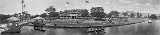
Haleiwa is located on Waialua Bay, the mouth of Anahulu Stream (also known as Anahulu River). A small boat harbor is located here, and the shore of the bay is surrounded by Haleiwa Beach Park (north side) and Haleiwa Alii Beach Park (south side). Further west from the center of town is Kaiaka State Recreation Area on Kiaka Point beside Kaiaka Bay. As of the 2000 Census, the CDP had a total population of 2,225, and is the largest commercial center on the North Shore of the Island. Its old plantation town character is preserved in many of the buildings, making this a popular destination for tourists and residents alike, visiting surfing and diving sites along the north shore.
The U.S. postal code
for Haleiwa, including Kawailoa, is 96712.
(State route 83) from Pūpūkea. At Haleiwa, Kamehameha Highway becomes state route 99 (at the traffic circle
known as "Weed Circle"), which runs eastward up across the Oahu central plateau to Wahiawā. A new bypass route (Joseph P. Leong Highway) avoids both the traffic circle and Haleiwa, extending state route 83 to just north of Haleiwa town. Haleiwa Road and both Kaukonahua Road and Waialua Beach Road from Weed Circle go south and southwest into Waialua across Paukauila Stream.
According to the United States Census Bureau
, the CDP has a total area of 2.5 square miles (6.5 km²). 1.8 square miles (4.7 km²) of it is land and 0.7 square miles (1.8 km²) of it is water. The total area is 28.06% water.
opened a hotel in the North Shore area and named it Haleiwa. In the Hawaiian language
, hale means "house", and the iwa is a frigatebird
.
On December 7, 1941 the only fighter aircraft that managed to scramble against the Japanese attack on Pearl Harbor
took off from the now-abandoned Haleiwa Airfield
.
was then 469.4/km² (1,218.1/mi²). There were 867 housing units at an average density of 474.6 per square mile (182.9/km²). The racial makeup of the CDP was 24.63% White, 0.49% Black or African American, 0.31% Native American, 28.85% Asian, 9.98% Pacific Islander, 0.81% from other races, and 34.92% from two or more races. 10.29% of the population were Hispanic or Latino of any race.
There were 770 households out of which 28.8% had children under the age of 18 living with them, 45.7% were married couples
living together, 14.4% had a female householder with no husband present, and 31.7% were non-families. 24.4% of all households were made up of individuals and 8.7% had someone living alone who was 65 years of age or older. The average household size was 2.88 and the average family size was 3.46.
In the CDP the population was spread out with 26.2% under the age of 18, 9.7% from 18 to 24, 27.2% from 25 to 44, 24.6% from 45 to 64, and 12.3% who were 65 years of age or older. The median age was 36 years. For every 100 females there were 103.6 males. For every 100 females age 18 and over, there were 101.1 males.
The median income for a household in the CDP was $39,643, and the median income for a family was $48,553. Males had a median income of $31,750 versus $25,163 for females. The per capita income
for the CDP was $16,504. 17.6% of the population and 15.0% of families were below the poverty line. Out of the total population, 26.2% of those under the age of 18 and 6.7% of those 65 and older were living below the poverty line.

North Shore (Oahu)
The North Shore, in the context of geography of the Island of Oahu, refers to the north-facing coastal area of Oahu between Kaena Point and Kahuku Point...
community and census-designated place
Census-designated place
A census-designated place is a concentration of population identified by the United States Census Bureau for statistical purposes. CDPs are delineated for each decennial census as the statistical counterparts of incorporated places such as cities, towns and villages...
(CDP) in the Waialua District of the island of Oahu
Oahu
Oahu or Oahu , known as "The Gathering Place", is the third largest of the Hawaiian Islands and most populous of the islands in the U.S. state of Hawaii. The state capital Honolulu is located on the southeast coast...
, City and County of Honolulu
Honolulu County, Hawaii
The City and County of Honolulu is a consolidated city–county located in the U.S. state of Hawaii. The municipality and county includes both the urban district of Honolulu and the rest of the island of Oahu, as well as several minor outlying islands, including all of the Northwestern Hawaiian...
.
Haleiwa is located on Waialua Bay, the mouth of Anahulu Stream (also known as Anahulu River). A small boat harbor is located here, and the shore of the bay is surrounded by Haleiwa Beach Park (north side) and Haleiwa Alii Beach Park (south side). Further west from the center of town is Kaiaka State Recreation Area on Kiaka Point beside Kaiaka Bay. As of the 2000 Census, the CDP had a total population of 2,225, and is the largest commercial center on the North Shore of the Island. Its old plantation town character is preserved in many of the buildings, making this a popular destination for tourists and residents alike, visiting surfing and diving sites along the north shore.
The U.S. postal code
Postal code
A postal code is a series of letters and/or digits appended to a postal address for the purpose of sorting mail. Once postal codes were introduced, other applications became possible.In February 2005, 117 of the 190 member countries of the Universal Postal Union had postal code systems...
for Haleiwa, including Kawailoa, is 96712.
Geography
Haleiwa is located at 21°35'24" North, 158°6'50" West (21.590050, -158.113928), southwest along Kamehameha HighwayKamehameha Highway
Kamehameha Highway is one of the main highways serving suburban and rural O‘ahu in the U.S. state of Hawaii. Starting from Nimitz Highway near Pearl Harbor and Hickam Air Force Base in Honolulu, it serves the island's older western suburbs, turning north across the O‘ahu Central Valley to the...
(State route 83) from Pūpūkea. At Haleiwa, Kamehameha Highway becomes state route 99 (at the traffic circle
Traffic circle
A traffic circle or rotary is a type of circular intersection in which traffic must travel in one direction around a central island. In some countries, traffic entering the circle has the right-of-way and drivers in the circle must yield. In many other countries, traffic entering the circle must...
known as "Weed Circle"), which runs eastward up across the Oahu central plateau to Wahiawā. A new bypass route (Joseph P. Leong Highway) avoids both the traffic circle and Haleiwa, extending state route 83 to just north of Haleiwa town. Haleiwa Road and both Kaukonahua Road and Waialua Beach Road from Weed Circle go south and southwest into Waialua across Paukauila Stream.
According to the United States Census Bureau
United States Census Bureau
The United States Census Bureau is the government agency that is responsible for the United States Census. It also gathers other national demographic and economic data...
, the CDP has a total area of 2.5 square miles (6.5 km²). 1.8 square miles (4.7 km²) of it is land and 0.7 square miles (1.8 km²) of it is water. The total area is 28.06% water.
History
In 1898 a businessman named Benjamin DillinghamBenjamin Dillingham
Benjamin Franklin Dillingham was a businessman and industrialist during the late Kingdom of Hawaii era, throughout the period of the Republic of Hawaii, and during the first two decades of the Territory of Hawaii.-Life:...
opened a hotel in the North Shore area and named it Haleiwa. In the Hawaiian language
Hawaiian language
The Hawaiian language is a Polynesian language that takes its name from Hawaii, the largest island in the tropical North Pacific archipelago where it developed. Hawaiian, along with English, is an official language of the state of Hawaii...
, hale means "house", and the iwa is a frigatebird
Frigatebird
The frigatebirds are a family, Fregatidae, of seabirds. There are five species in the single genus Fregata. They are also sometimes called Man of War birds or Pirate birds. Since they are related to the pelicans, the term "frigate pelican" is also a name applied to them...
.
On December 7, 1941 the only fighter aircraft that managed to scramble against the Japanese attack on Pearl Harbor
Attack on Pearl Harbor
The attack on Pearl Harbor was a surprise military strike conducted by the Imperial Japanese Navy against the United States naval base at Pearl Harbor, Hawaii, on the morning of December 7, 1941...
took off from the now-abandoned Haleiwa Airfield
Haleiwa Fighter Strip
Haleiwa Fighter Strip was a military airfield located on Oahu, Hawaii. It was used as part of the island's defense in World War II.-History:This obscure former military strip became famous during the December 7, 1941 attack on Pearl Harbor....
.
Demographics
As of the 2000 Census, there were 2,225 people, 770 households, and 525 families residing in the CDP. The population densityPopulation density
Population density is a measurement of population per unit area or unit volume. It is frequently applied to living organisms, and particularly to humans...
was then 469.4/km² (1,218.1/mi²). There were 867 housing units at an average density of 474.6 per square mile (182.9/km²). The racial makeup of the CDP was 24.63% White, 0.49% Black or African American, 0.31% Native American, 28.85% Asian, 9.98% Pacific Islander, 0.81% from other races, and 34.92% from two or more races. 10.29% of the population were Hispanic or Latino of any race.
There were 770 households out of which 28.8% had children under the age of 18 living with them, 45.7% were married couples
Marriage
Marriage is a social union or legal contract between people that creates kinship. It is an institution in which interpersonal relationships, usually intimate and sexual, are acknowledged in a variety of ways, depending on the culture or subculture in which it is found...
living together, 14.4% had a female householder with no husband present, and 31.7% were non-families. 24.4% of all households were made up of individuals and 8.7% had someone living alone who was 65 years of age or older. The average household size was 2.88 and the average family size was 3.46.
In the CDP the population was spread out with 26.2% under the age of 18, 9.7% from 18 to 24, 27.2% from 25 to 44, 24.6% from 45 to 64, and 12.3% who were 65 years of age or older. The median age was 36 years. For every 100 females there were 103.6 males. For every 100 females age 18 and over, there were 101.1 males.
The median income for a household in the CDP was $39,643, and the median income for a family was $48,553. Males had a median income of $31,750 versus $25,163 for females. The per capita income
Per capita income
Per capita income or income per person is a measure of mean income within an economic aggregate, such as a country or city. It is calculated by taking a measure of all sources of income in the aggregate and dividing it by the total population...
for the CDP was $16,504. 17.6% of the population and 15.0% of families were below the poverty line. Out of the total population, 26.2% of those under the age of 18 and 6.7% of those 65 and older were living below the poverty line.
Education
The Hawaii Department of Education operates public schools. Haleiwa Elementary School is in the CDP.