
H6 Childs Way
Encyclopedia
Milton Keynes
Milton Keynes , sometimes abbreviated MK, is a large town in Buckinghamshire, in the south east of England, about north-west of London. It is the administrative centre of the Borough of Milton Keynes...
, Buckinghamshire, England
England
England is a country that is part of the United Kingdom. It shares land borders with Scotland to the north and Wales to the west; the Irish Sea is to the north west, the Celtic Sea to the south west, with the North Sea to the east and the English Channel to the south separating it from continental...
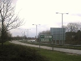
. It runs for 6 miles (10 kilometres) from the western boundary of Milton Keynes at Kingsmead to a point near its eastern edge, just short of Junction 14 of the M1 Motorway
M1 motorway
The M1 is a north–south motorway in England primarily connecting London to Leeds, where it joins the A1 near Aberford. While the M1 is considered to be the first inter-urban motorway to be completed in the United Kingdom, the first road to be built to motorway standard in the country was the...
. The formal name of the road is simply Childs Way; the H6 is a number that signifies that the road is the sixth east-west road in the Milton Keynes grid system
Milton Keynes grid road system
The Milton Keynes grid road system is a network of national speed limit, fully landscaped routes that form the top layer of the street hierarchy for both for private and public transport in Milton Keynes, Buckinghamshire...
.
Route
The H6 starts as a 30 mph (13.4 m/s) local distributor road between the districts of Kingsmead and Whitney. After crossing Whitney Roundabout the road becomes 60 mph (26.8 m/s) but remains as a single carriageway. After bridging Powis Lane in between Westcroft and Oxley Park the road becomes a dual carriageway at Shenley Roundabout. It then passes very close to the Grove Independent School and subsequently bridges both the A5 and the West Coast Main LineWest Coast Main Line
The West Coast Main Line is the busiest mixed-traffic railway route in Britain, being the country's most important rail backbone in terms of population served. Fast, long-distance inter-city passenger services are provided between London, the West Midlands, the North West, North Wales and the...
. The road then crosses the V6 Grafton Street
V6 Grafton Street
The V6 Grafton Street is a major local road in Milton Keynes. Its formal name is simply "Grafton Street": the "V6" designation is an urban planning name that indicates that it is the sixth north-south grid road in the Milton Keynes grid road system....
and runs along the southern edge of Central Milton Keynes
Central Milton Keynes
Central Milton Keynes is the central business district of Milton Keynes, Buckinghamshire, England and a civil parish in its own right.The district is approximately 2.5 km long by 1 km wide and occupies some of the highest land in Milton Keynes...
and Campbell Park
Campbell Park
Campbell Park is a district in east-central and south-central Milton Keynes, Buckinghamshire, England, the central park for Milton Keynes, and a civil parish that includes other districts. According to the 2001 census the parish had a population of 13,364...
before passing Willen Lake. After this it passes the original Milton Keynes village
Middleton, Milton Keynes
Middleton is a district in Milton Keynes, Buckinghamshire, England. The district is centred on Milton Keynes Village, the village that gave its name to the 'New City' of Milton Keynes, which began to be developed during the late 1960s...
and then curves up to meet the A509
A509 road
The A509 is a short A-class road for north-south journeys in south central England, forming the route from Kettering in Northamptonshire to the M1 and A5 in Milton Keynes....
, briefly becoming the A4146
A4146 road
The A4146 is an A-class road running through south-central England from M1 Junction 14 at Milton Keynes, around Linslade and Leighton Buzzard , and via Dagnall to Hemel Hempstead, where it terminates at a roundabout with the A4251.In Milton Keynes, the road briefly follows the H6 Childs Way from...
.
Junctions
Due to its nature as a Milton Keynes grid road, Childs Way has an unusual number of roundabouts (by the standards of other towns) along its short route. For clarity their names and the roads they cross are listed below from west to east:| Roundabout Name | Intersection |
|---|---|
| Unnamed mini roundabout | Harlow Crescent, Saltwood Avenue |
| Whitney Roundabout | V1 Snelshall Street |
| Oxley Park Roundabout | V2 Tattenhoe Street |
| Shenley Roundabout | V3 Fulmer Street |
| Knowlhill Roundabout | V4 Watling Street |
| South Grafton Roundabout | V6 Grafton Street V6 Grafton Street The V6 Grafton Street is a major local road in Milton Keynes. Its formal name is simply "Grafton Street": the "V6" designation is an urban planning name that indicates that it is the sixth north-south grid road in the Milton Keynes grid road system.... / Gate |
| South Witan Roundabout | Witan Gate, Evans Gate |
| South Saxon Roundabout | V7 Saxon Street / Gate |
| South Secklow Roundabout | Secklow Gate, Pentewan Gate |
| Springfield Roundabout | V8 Marlborough Street V8 Marlborough Street The V8 Marlborough Street is a major local road in Milton Keynes, running for approximately eight miles. Its formal name is simply Marlborough Street; the V8 designation is an urban planning name that indicates that it is the eighth north-south grid road in the Milton Keynes grid road system... |
| South Enmore Roundabout | Enmore Gate, Kenwood Gate |
| South Overgate Roundabout | V9 Overgate |
| Woolstone Roundabout | V10 Brickhill Street |
| Fox Milne Roundabout | V11 Tongwell Street |
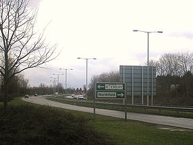
| Northfield Roundabout | H5 Portway and A5130 A5130 road The A5130 is a road in the United Kingdom. It starts on a roundabout with the A509 near Junction 14 of the M1 motorway and proceeds south round the eastern edge of the original Milton Keynes designated area. After crossing the A421 the 5130 continues past the village of Wavendon. It then crosses... |