

Güímar
Encyclopedia
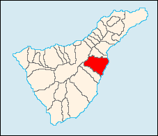
| Güímar | |
| Map | |
|---|---|
 |
|
| Statistics | |
| Autonomous region: | Canary Islands Canary Islands The Canary Islands , also known as the Canaries , is a Spanish archipelago located just off the northwest coast of mainland Africa, 100 km west of the border between Morocco and the Western Sahara. The Canaries are a Spanish autonomous community and an outermost region of the European Union... |
| Province: | Santa Cruz de Tenerife Santa Cruz de Tenerife (province) Province of Santa Cruz de Tenerife also Province of Santa Cruz is a province of Spain, consisting of the western part of the autonomous community of the Canary Islands. It consists of about half of the Atlantic archipelago, including the islands of Tenerife, La Gomera, El Hierro, and La Palma, and... |
| Island: | Tenerife Tenerife Tenerife is the largest and most populous island of the seven Canary Islands, it is also the most populated island of Spain, with a land area of 2,034.38 km² and 906,854 inhabitants, 43% of the total population of the Canary Islands. About five million tourists visit Tenerife each year, the... |
| Area Area Area is a quantity that expresses the extent of a two-dimensional surface or shape in the plane. Area can be understood as the amount of material with a given thickness that would be necessary to fashion a model of the shape, or the amount of paint necessary to cover the surface with a single coat... : |
102.92 km² |
| Population Population A population is all the organisms that both belong to the same group or species and live in the same geographical area. The area that is used to define a sexual population is such that inter-breeding is possible between any pair within the area and more probable than cross-breeding with individuals... : |
16,251 (2001) |
| Population density Population density Population density is a measurement of population per unit area or unit volume. It is frequently applied to living organisms, and particularly to humans... : |
157.9/km² |
| Elevation Elevation The elevation of a geographic location is its height above a fixed reference point, most commonly a reference geoid, a mathematical model of the Earth's sea level as an equipotential gravitational surface .... : Lowest: Centre: Highest: |
Atlantic Ocean 289 m Montaña Grande |
Tenerife
Tenerife is the largest and most populous island of the seven Canary Islands, it is also the most populated island of Spain, with a land area of 2,034.38 km² and 906,854 inhabitants, 43% of the total population of the Canary Islands. About five million tourists visit Tenerife each year, the...
, one of the Canary Islands
Canary Islands
The Canary Islands , also known as the Canaries , is a Spanish archipelago located just off the northwest coast of mainland Africa, 100 km west of the border between Morocco and the Western Sahara. The Canaries are a Spanish autonomous community and an outermost region of the European Union...
, and part of Santa Cruz de Tenerife (province)
Santa Cruz de Tenerife (province)
Province of Santa Cruz de Tenerife also Province of Santa Cruz is a province of Spain, consisting of the western part of the autonomous community of the Canary Islands. It consists of about half of the Atlantic archipelago, including the islands of Tenerife, La Gomera, El Hierro, and La Palma, and...
. The municipality is located in the southeastern end of the island, and extends for 1,029 square kilometers from the mountainous interior to the beaches on the Atlantic
Atlantic Ocean
The Atlantic Ocean is the second-largest of the world's oceanic divisions. With a total area of about , it covers approximately 20% of the Earth's surface and about 26% of its water surface area...
, and borders the municipalities of La Orotava, Arafo
Arafo
Arafo is a municipality of the northeastern part of the island of Tenerife in the Santa Cruz de Tenerife , on the Canary Islands. The city is also a suburb of Santa Cruz city....
, and Fasnia
Fasnia
Fasnia is the name of a municipality, town, and valley in the eastern part of the Spanish island of Tenerife, one of the Canary Islands, and part of the province of Santa Cruz de Tenerife. The municipality is located in the southeastern end of the island, and extends for from the mountainous...
. Its estimated population is 15,271. It is linked with the TF1 Motorway
TF1 Motorway
The TF-1 is a superhighway encircling the eastern and the southern parts of the island of Tenerife . The TF-1 motorway runs from the capital Santa Cruz in the north to Adeje with its major tourist resorts Los Cristianos and Playa de las Américas in the south of the island...
superhighway and has an interchange near and is also linked with the old highway linking Arona and Santa Cruz City,which it is also a suburb of and is one of the southernmost.
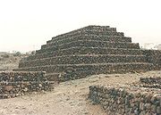
The municipality is famous for its Guanche Pyramids
Pyramids of Güímar
The Pyramids of Güímar refer to six rectangular pyramid-shaped, terraced structures, built from lava stone without the use of mortar. They are located in the district of Chacona, part of the town of Güímar on the island of Tenerife in the Canary Islands...
. Also, a portion of its volcanic landscape has been set aside as the Reserva Natural del Malpaís de Güímar, its highest point being Montaña Grande. It is also in place the Barranco de Badajoz
Barranco de Badajoz
The Barranco de Badajoz or Chamoco is a ravine on the island of Tenerife , part of the municipality of Güímar in the southeast of the island....
.
External links
- Official Website
- Map and aerial photos
- Street map: Street map from Mapquest, MapPoint or Google
- Satellite images: Google
- Coordinates: 28°29′0"N 16°18′0"W