
Guntur Coast
Encyclopedia
Guntur Coast is the coastal region of Guntur
District
. It is on the east coast region of India
. The length of the Guntur coast line is around 100KM.
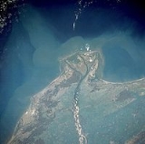
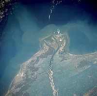 Guntur Coast Line is typical of the wider deltas along the southeast coast of India (also known as the Coromandel Coast) (quotes from NASA site ). Krishna merges into the ocean in the Guntur Coast. The braided stream channels, broad floodplain, and extensive sandbars suggest that this part of the Krishna River flows through relatively flat terrain and carries substantial amounts of sediment, especially during the monsoon season. The closest city of the Guntur coast is Guntur City.
A Port City to be built near Nizampatnam
in Guntur District. This is part of a major renovation of the Nizampatnam Harbour. The development of this harbour will enable the Guntur region to be a major port city, with direct access for exports and imports around the world Projects Today,Yahoo News.
Suryalanka is a tourist shore point 40 miles south of Guntur City, with all desirable features of a sea shore. It has all the facilities for stay and entertainment of visitors.
This is another shore point very close to the region where the River Krishna merges into Bay of Bengal
.
Guntur
Guntur , is a city and a municipal corporation in the Indian state of Andhra Pradesh, located to the north and west of the Bay of Bengal. It is approximately to the south of the national capital, New Delhi and south east of state capital, Hyderabad. Guntur is the fourth largest city in Andhra...
District
Guntur district
Guntur district is located in Andhra Pradesh along the east coast of Bay of Bengal. The district has a coastline of around 100 kilometers. Guntur City is the largest city in the district and administrative center of Guntur District. The district is a major center for learning.-Etymology:There are...
. It is on the east coast region of India
India
India , officially the Republic of India , is a country in South Asia. It is the seventh-largest country by geographical area, the second-most populous country with over 1.2 billion people, and the most populous democracy in the world...
. The length of the Guntur coast line is around 100KM.
Introduction
Harbor
- Port City Complex in Guntur District/Nizampatnam Harbour
A Port City to be built near Nizampatnam
Nizampatnam
Nizampatnam, also known as Petapolly , is a seaport town in Andhra Pradesh state of southern India. Nizampatnam is located in Guntur District, of which it is a mandal, in the delta of the Krishna River, which empties into the Bay of Bengal...
in Guntur District. This is part of a major renovation of the Nizampatnam Harbour. The development of this harbour will enable the Guntur region to be a major port city, with direct access for exports and imports around the world Projects Today,Yahoo News.
Beaches/Shore Points
- Surya Lanka near BapatlaBapatlaBapatla, formerly known as Bhavapuri, is a town and mandal of Guntur District, Andhra Pradesh, India. It is located south of Guntur City on the East Coast.-Assembly constituency:Bapatla is an assembly constituency in Andhra Pradesh....
Suryalanka is a tourist shore point 40 miles south of Guntur City, with all desirable features of a sea shore. It has all the facilities for stay and entertainment of visitors.
- Bobbara Lanka RepalleRepalleRepalle is a town, mandal and a municipality in Guntur district in the Indian state of Andhra Pradesh. It is located 28 miles south of Guntur.-Geography:Repalle is located at...
This is another shore point very close to the region where the River Krishna merges into Bay of Bengal
Bay of Bengal
The Bay of Bengal , the largest bay in the world, forms the northeastern part of the Indian Ocean. It resembles a triangle in shape, and is bordered mostly by the Eastern Coast of India, southern coast of Bangladesh and Sri Lanka to the west and Burma and the Andaman and Nicobar Islands to the...
.