
Greensboro neighborhoods
Encyclopedia
The following is a list of neighborhoods, districts, and other places located in the city of Greensboro
, North Carolina
. The list is organized by broad geographical section within the city. While there is no official list of neighborhoods, districts, and places, this list was compiled from the sources listed in the External links section, as well as from information compiled from residents of Greensboro.
 Greensboro's neighborhoods have no "official" borders, such that some of the places listed below may overlap geographically, and residents are not always in agreement with where one neighborhood ends and another begins.
Historically, many neighborhoods were defined by platted subdivisions. Others were originally villages before being incorporated as part of the city. Still more complicated is the fact that in some parts of Greensboro, especially the central areas of East and South Greensboro, residents have long been more likely to identify with the name of their section of the city than with any specific neighborhood name. Today, community-based organizations, homeowner's associations, neighborhood watch
es, and other civic organizations are an influential force in shaping the use of neighborhood names and approximate boundaries.
Greensboro, North Carolina
Greensboro is a city in the U.S. state of North Carolina. It is the third-largest city by population in North Carolina and the largest city in Guilford County and the surrounding Piedmont Triad metropolitan region. According to the 2010 U.S...
, North Carolina
North Carolina
North Carolina is a state located in the southeastern United States. The state borders South Carolina and Georgia to the south, Tennessee to the west and Virginia to the north. North Carolina contains 100 counties. Its capital is Raleigh, and its largest city is Charlotte...
. The list is organized by broad geographical section within the city. While there is no official list of neighborhoods, districts, and places, this list was compiled from the sources listed in the External links section, as well as from information compiled from residents of Greensboro.
Historically, many neighborhoods were defined by platted subdivisions. Others were originally villages before being incorporated as part of the city. Still more complicated is the fact that in some parts of Greensboro, especially the central areas of East and South Greensboro, residents have long been more likely to identify with the name of their section of the city than with any specific neighborhood name. Today, community-based organizations, homeowner's associations, neighborhood watch
Neighborhood watch
A neighborhood watch or neighbourhood watch , also called a crime watch or neighborhood crime watch, is an organized group of citizens devoted to crime and vandalism prevention within a neighborhood...
es, and other civic organizations are an influential force in shaping the use of neighborhood names and approximate boundaries.
North Greensboro
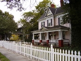
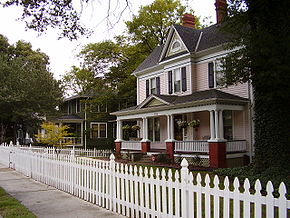
- Fisher ParkFisher Park, Greensboro, North CarolinaFisher Park is a neighborhood in the north central section of the United States city of Greensboro, North Carolina. Captain Basil J. Fisher turned a swamp into Greensboro's most fashionable Gilded Era address in 1901 when he donated the lowlands for a city park that bears his name...
Breadth: North to Wendover Avenue, East to the Southern Railway, South to Smith Street, East to Wharton Street. - Lake Jeanette
- Latham Park
- Irving Park
- New Irving Park
- Bur-Mil Park
East Greensboro
- AycockAycock, Greensboro, North CarolinaAycock is a neighborhood in the northeast section of the United States city of Greensboro, North Carolina. The Aycock neighborhood was named for the Charles B. Aycock Middle School located within the neighborhood...
- Dudley Heights
- Old L. Richardson
- East White Oaks, Greensboro, North Carolina
- White Oak New Town
- Willow Oaks
South Greensboro
- Adams Farm
- Asheboro Square
- Grandover
- Ole Asheboro
- Sedgefield Breadth: North to High Point Road, East to Groomtown Road, South to Rockingham Road, East, West to Guilford College Road.
- SouthsideSouthside, Greensboro, North CarolinaSouthside is an urban neighborhood in the south central section of the United States city of Greensboro, North Carolina. Southside has also been known as the Ol' Asheboro neighborhood, Arlington Park, the Asheboro Street neighborhood, and the South Greensboro neighborhood...
greensboro, North Carolina-Randleman rd., Holden rd., W.Florida st., S.Elm Eugene st.,(Smith Homes, Hampton Homes, Parkside, J.T. Hariston Homes, Terrell Street apts., Wynnmere)
West Greensboro
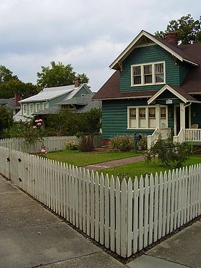
- College HillCollege Hill, Greensboro, North CarolinaCollege Hill is a neighborhood in the west central section of the United States city of Greensboro, North Carolina. College Hill has the distinction of being Greensboro’s first neighborhood. The narrow streets lined with Queen Anne mansions and humble bungalows are enhanced by offbeat boutiques and...
Breadth: North to West Market Street, East to Spring Street, South to the Southern Railroad, West to McIver Street. - Glenwood Breadth: North to West Lee Street, East to Freeman Mill Road, West to Coliseum Boulevard.
- Hamilton Lakes
- Jefferson Woods
- Lindley Park
- Starmount
- Starmount Forest
- Sunset Hills
- The Cardinal
- Westerwood