

Great Flood of 1968
Encyclopedia
Flood
A flood is an overflow of an expanse of water that submerges land. The EU Floods directive defines a flood as a temporary covering by water of land not normally covered by water...
caused by very heavy rain that struck South East England
South East England
South East England is one of the nine official regions of England, designated in 1994 and adopted for statistical purposes in 1999. It consists of Berkshire, Buckinghamshire, East Sussex, Hampshire, Isle of Wight, Kent, Oxfordshire, Surrey and West Sussex...
and France
France
The French Republic , The French Republic , The French Republic , (commonly known as France , is a unitary semi-presidential republic in Western Europe with several overseas territories and islands located on other continents and in the Indian, Pacific, and Atlantic oceans. Metropolitan France...
in mid-September 1968, with the worst on Sunday 15 September 1968, and followed earlier floods in South West England
South West England
South West England is one of the regions of England defined by the Government of the United Kingdom for statistical and other purposes. It is the largest such region in area, covering and comprising Bristol, Gloucestershire, Somerset, Dorset, Wiltshire, Devon, Cornwall and the Isles of Scilly. ...
during July.
South West England
The River ChewRiver Chew
The River Chew is a small river in England. It merges with the River Avon after forming the Chew Valley.The spring from which the Chew rises is just upstream from Chewton Mendip. The river flows North West from Chewton Mendip through Litton, Chew Valley Lake, Chew Stoke, Chew Magna and Stanton Drew...
suffered a major flood in 1968 with serious damage to towns and villages along its route, including sweeping away the bridge at Pensford
Pensford
Pensford is a village in the civil parish of Publow and Pensford in Somerset, England. It lies in the Chew Valley south of Bristol and west of Bath...
.
On 10 July 1968, torrential rainfall, with 175 millimetres (6.9 in) falling in 18 hours on Chew Stoke
Chew Stoke
Chew Stoke is a small village and civil parish in the Chew Valley, in Somerset, England, about south of Bristol. It is at the northern edge of the Mendip Hills, a region designated by the United Kingdom as an Area of Outstanding Natural Beauty, and is within the Bristol/Bath green belt...
, double the area's average rainfall for the whole of July, led to widespread flooding in the Chew Valley, and water reached the first floor of many buildings. The damage in Chew Stoke was not as severe as in some of the surrounding villages, such as Pensford
Pensford
Pensford is a village in the civil parish of Publow and Pensford in Somerset, England. It lies in the Chew Valley south of Bristol and west of Bath...
where it swept away the bridge over the A37
A37 road
The A37 is a major road in southern England. It runs north from the A35 at Dorchester in Dorset into Somerset through Yeovil and Shepton Mallet before terminating at the Three Lamps junction with the A4 in central Bristol...
and damaged the railway viaduct so badly that it never reopened. It also flooded 88 properties in Chew Magna
Chew Magna
Chew Magna is a village and civil parish within the Chew Valley in the Unitary Authority of Bath and North East Somerset, in the Ceremonial county of Somerset, England. The parish has a population of 1,161.To the south of the village is Chew Valley Lake...
with many being inundated with 8 feet (2.4 m) of water. however, fears that the Chew Valley Lake
Chew Valley Lake
Chew Valley Lake is a large reservoir in the Chew Valley, Somerset, England, and the fifth-largest artificial lake in the United Kingdom , with an area of 1,200 acres...
dam would be breached caused considerable anxiety.
On the southern side of the Mendip Hills
Mendip Hills
The Mendip Hills is a range of limestone hills to the south of Bristol and Bath in Somerset, England. Running east to west between Weston-super-Mare and Frome, the hills overlook the Somerset Levels to the south and the Avon Valley to the north...
at Cheddar
Cheddar
Cheddar is a large village and civil parish in the Sedgemoor district of the English county of Somerset. It is situated on the southern edge of the Mendip Hills, north-west of Wells. The civil parish includes the hamlets of Nyland and Bradley Cross...
the flow of water swept large boulders down the gorge and damaged the cafe and entrance to Gough's Cave, washing away cars. In the cave itself the flooding lasted for three days.
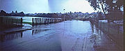
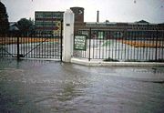
South East England
The areas worst hit were CrawleyCrawley
Crawley is a town and local government district with Borough status in West Sussex, England. It is south of Charing Cross, north of Brighton and Hove, and northeast of the county town of Chichester, covers an area of and had a population of 99,744 at the time of the 2001 Census.The area has...
, East Grinstead
East Grinstead
East Grinstead is a town and civil parish in the northeastern corner of Mid Sussex, West Sussex in England near the East Sussex, Surrey, and Kent borders. It lies south of London, north northeast of Brighton, and east northeast of the county town of Chichester...
, Horley
Horley
Horley is a town in Surrey, England, situated south of the twin towns of Reigate and Redhill, and north of Gatwick Airport and Crawley.With fast links by train to London from Horley railway station, it has grown popular with commuters in recent years...
, Lewisham
Lewisham
Lewisham is a district in South London, England, located in the London Borough of Lewisham. It is situated south-east of Charing Cross. The area is identified in the London Plan as one of 35 major centres in Greater London.-History:...
, Petersfield, Hampshire
Petersfield, Hampshire
Petersfield is a market town and civil parish in the East Hampshire district of Hampshire, England. It is north of Portsmouth, on the A3 road. The town has its own railway station on the Portsmouth Direct Line, the mainline rail link connecting Portsmouth and London. The town is situated on the...
, Redhill
Redhill, Surrey
Redhill is a town in the borough of Reigate and Banstead, Surrey, England and is part of the London commuter belt. Redhill and the adjacent town of Reigate form a single urban area.-History:...
, Tilbury
Tilbury
Tilbury is a town in the borough of Thurrock, Essex, England. As a settlement it is of relatively recent existence, although it has important historical connections, being the location of a 16th century fort and an ancient cross-river ferry...
, Tunbridge Wells
Royal Tunbridge Wells
Royal Tunbridge Wells is a town in west Kent, England, about south-east of central London by road, by rail. The town is close to the border of the county of East Sussex...
and Tonbridge
Tonbridge
Tonbridge is a market town in the English county of Kent, with a population of 30,340 in 2007. It is located on the River Medway, approximately 4 miles north of Tunbridge Wells, 12 miles south west of Maidstone and 29 miles south east of London...
.
On 15 September 1968 the 9:50 Charing Cross
Charing Cross railway station
Charing Cross railway station, also known as London Charing Cross, is a central London railway terminus in the City of Westminster, England. It is one of 18 stations managed by Network Rail, and trains serving it are operated by Southeastern...
to Hastings
Hastings railway station
Hastings railway station is in Hastings in East Sussex, England. It is situated on the Hastings Line to Tunbridge Wells, the East Coastway Line to Brighton and the Marshlink Line to Ashford International....
was diverted along the Edenbridge line, but was surrounded by flood water at Edenbridge railway station
Edenbridge railway station
Edenbridge railway station is one of two stations serving Edenbridge in Kent.In 1967 the station was destaffed following which the original station buildings were demolished....
. 150 passengers spent 12 hours stuck on the train.
France
In the first seven hours of 15 September 1968 three inches of rain fell on NiceNice
Nice is the fifth most populous city in France, after Paris, Marseille, Lyon and Toulouse, with a population of 348,721 within its administrative limits on a land area of . The urban area of Nice extends beyond the administrative city limits with a population of more than 955,000 on an area of...
. In Toulon
Toulon
Toulon is a town in southern France and a large military harbor on the Mediterranean coast, with a major French naval base. Located in the Provence-Alpes-Côte-d'Azur region, Toulon is the capital of the Var department in the former province of Provence....
a cyclist was killed by an electricity cable
Electric power transmission
Electric-power transmission is the bulk transfer of electrical energy, from generating power plants to Electrical substations located near demand centers...
that had fallen into the flooded road. The wine harvest was seriously damaged.