

Grant County, Arkansas
Encyclopedia
Grant County is a county
in the U.S. state
of Arkansas
. Its population was 17,853 at the 2010 United States Census
. The county seat
is Sheridan
. Grant County is included in the Little Rock
–North Little Rock
–Conway
Metropolitan Statistical Area.It is a rural county.The county seat, Sheridan was named after Union General Philip Sheridan.
Grant County was formed on February 4, 1869, and named for Ulysses S. Grant
, president of the United States
. It is an alcohol prohibition or dry county
.
Robert W. Glover
, a Missionary Baptist pastor who served in both houses of the Arkansas Legislature (1905-1912) from Sheridan, introduced in 1909 the resolution calling for the establishment of four state agricultural colleges.
 As of the census
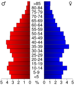
of 2000, there were 16,464 people, 4,241 households, and 4,780 families residing in the county. The population density
was 26 people per square mile (10/km²). There were 6,960 housing units at an average density of 11 per square mile (4/km²). The racial makeup of the county was 95.55% White
, 2.47% Black
or African American
, 0.45% Native American
, 0.13% Asian
, 0.03% Pacific Islander
, 0.64% from other races
, and 0.73% from two or more races. 1.15% of the population were Hispanic
or Latino
of any race.
There were 6,241 households out of which 35.60% had children under the age of 18 living with them, 64.70% were married couples
living together, 8.50% had a female householder with no husband present, and 23.40% were non-families. 20.40% of all households were made up of individuals and 9.00% had someone living alone who was 65 years of age or older. The average household size was 2.61 and the average family size was 3.00.
In the county the population was spread out with 25.90% under the age of 18, 8.00% from 18 to 24, 29.60% from 25 to 44, 24.30% from 45 to 64, and 12.20% who were 65 years of age or older. The median age was 37 years. For every 100 females there were 98.50 males. For every 100 females age 18 and over, there were 96.30 males.
The median income for a household in the county was $37,182, and the median income for a family was $42,901. Males had a median income of $31,842 versus $22,098 for females. The per capita income
for the county was $17,547. About 7.80% of families and 10.20% of the population were below the poverty line, including 12.50% of those under age 18 and 13.00% of those age 65 or over.
County (United States)
In the United States, a county is a geographic subdivision of a state , usually assigned some governmental authority. The term "county" is used in 48 of the 50 states; Louisiana is divided into parishes and Alaska into boroughs. Parishes and boroughs are called "county-equivalents" by the U.S...
in the U.S. state
U.S. state
A U.S. state is any one of the 50 federated states of the United States of America that share sovereignty with the federal government. Because of this shared sovereignty, an American is a citizen both of the federal entity and of his or her state of domicile. Four states use the official title of...
of Arkansas
Arkansas
Arkansas is a state located in the southern region of the United States. Its name is an Algonquian name of the Quapaw Indians. Arkansas shares borders with six states , and its eastern border is largely defined by the Mississippi River...
. Its population was 17,853 at the 2010 United States Census
United States Census, 2010
The Twenty-third United States Census, known as Census 2010 or the 2010 Census, is the current national census of the United States. National Census Day was April 1, 2010 and is the reference date used in enumerating individuals...
. The county seat
County seat
A county seat is an administrative center, or seat of government, for a county or civil parish. The term is primarily used in the United States....
is Sheridan
Sheridan, Arkansas
Sheridan is the largest city and county seat in Grant County, Arkansas, United States. The population was 3,872 at the 2000 census. It is part of the Little Rock–North Little Rock–Conway Metropolitan Statistical Area. .-History:Robert W...
. Grant County is included in the Little Rock
Little Rock, Arkansas
Little Rock is the capital and the largest city of the U.S. state of Arkansas. The Metropolitan Statistical Area had a population of 699,757 people in the 2010 census...
–North Little Rock
North Little Rock, Arkansas
the city was 62.55% White, 33.98% Black or African American, 0.41% Native American, 0.59% Asian, 0.03% Pacific Islander, 1.18% from other races, and 1.26% from two or more races...
–Conway
Conway, Arkansas
Conway is the county seat of Faulkner County, Arkansas, United States. The population was 58,908 at the 2010 census, making Conway the seventh most populous city in Arkansas. It is a principal city of the Little Rock–North Little Rock–Conway Metropolitan Statistical Area which had...
Metropolitan Statistical Area.It is a rural county.The county seat, Sheridan was named after Union General Philip Sheridan.
Grant County was formed on February 4, 1869, and named for Ulysses S. Grant
Ulysses S. Grant
Ulysses S. Grant was the 18th President of the United States as well as military commander during the Civil War and post-war Reconstruction periods. Under Grant's command, the Union Army defeated the Confederate military and ended the Confederate States of America...
, president of the United States
President of the United States
The President of the United States of America is the head of state and head of government of the United States. The president leads the executive branch of the federal government and is the commander-in-chief of the United States Armed Forces....
. It is an alcohol prohibition or dry county
Dry county
A dry county is a county in the United States whose government forbids the sale of alcoholic beverages. Some prohibit off-premises sale, some prohibit on-premises sale, and some prohibit both. Hundreds of dry counties exist across the United States, almost all of them in the South...
.
Robert W. Glover
Robert W. Glover
Robert W. Glover, sometimes known as Bob Glover , was a Baptist pastor and a Democratic politician from Sheridan in Grant County in south Arkansas.-Background:...
, a Missionary Baptist pastor who served in both houses of the Arkansas Legislature (1905-1912) from Sheridan, introduced in 1909 the resolution calling for the establishment of four state agricultural colleges.
Geography
According to the 2000 census, the county has a total area of 633.01 square miles (1,639.5 km²), of which 631.78 square miles (1,636.3 km²) (or 99.81%) is land and 1.23 square miles (3.2 km²) (or 0.19%) is water.Major highways
 U.S. Highway 167
 U.S. Highway 270
 Highway 35
 Highway 46
Adjacent counties
- Saline County (north)
- Pulaski County (northeast)
- Jefferson CountyJefferson County, ArkansasJefferson County is a county located in the U.S. state of Arkansas. Its population was 77,435 at the 2010 United States Census. It is included in the Pine Bluff Metropolitan Statistical Area. Jefferson County's county seat and largest city is Pine Bluff...
(east) - Cleveland County (southeast)
- Dallas County (south)
- Hot Spring County (west)
Demographics
Census
A census is the procedure of systematically acquiring and recording information about the members of a given population. It is a regularly occurring and official count of a particular population. The term is used mostly in connection with national population and housing censuses; other common...
of 2000, there were 16,464 people, 4,241 households, and 4,780 families residing in the county. The population density
Population density
Population density is a measurement of population per unit area or unit volume. It is frequently applied to living organisms, and particularly to humans...
was 26 people per square mile (10/km²). There were 6,960 housing units at an average density of 11 per square mile (4/km²). The racial makeup of the county was 95.55% White
Race (United States Census)
Race and ethnicity in the United States Census, as defined by the Federal Office of Management and Budget and the United States Census Bureau, are self-identification data items in which residents choose the race or races with which they most closely identify, and indicate whether or not they are...
, 2.47% Black
Race (United States Census)
Race and ethnicity in the United States Census, as defined by the Federal Office of Management and Budget and the United States Census Bureau, are self-identification data items in which residents choose the race or races with which they most closely identify, and indicate whether or not they are...
or African American
Race (United States Census)
Race and ethnicity in the United States Census, as defined by the Federal Office of Management and Budget and the United States Census Bureau, are self-identification data items in which residents choose the race or races with which they most closely identify, and indicate whether or not they are...
, 0.45% Native American
Race (United States Census)
Race and ethnicity in the United States Census, as defined by the Federal Office of Management and Budget and the United States Census Bureau, are self-identification data items in which residents choose the race or races with which they most closely identify, and indicate whether or not they are...
, 0.13% Asian
Race (United States Census)
Race and ethnicity in the United States Census, as defined by the Federal Office of Management and Budget and the United States Census Bureau, are self-identification data items in which residents choose the race or races with which they most closely identify, and indicate whether or not they are...
, 0.03% Pacific Islander
Race (United States Census)
Race and ethnicity in the United States Census, as defined by the Federal Office of Management and Budget and the United States Census Bureau, are self-identification data items in which residents choose the race or races with which they most closely identify, and indicate whether or not they are...
, 0.64% from other races
Race (United States Census)
Race and ethnicity in the United States Census, as defined by the Federal Office of Management and Budget and the United States Census Bureau, are self-identification data items in which residents choose the race or races with which they most closely identify, and indicate whether or not they are...
, and 0.73% from two or more races. 1.15% of the population were Hispanic
Race (United States Census)
Race and ethnicity in the United States Census, as defined by the Federal Office of Management and Budget and the United States Census Bureau, are self-identification data items in which residents choose the race or races with which they most closely identify, and indicate whether or not they are...
or Latino
Race (United States Census)
Race and ethnicity in the United States Census, as defined by the Federal Office of Management and Budget and the United States Census Bureau, are self-identification data items in which residents choose the race or races with which they most closely identify, and indicate whether or not they are...
of any race.
There were 6,241 households out of which 35.60% had children under the age of 18 living with them, 64.70% were married couples
Marriage
Marriage is a social union or legal contract between people that creates kinship. It is an institution in which interpersonal relationships, usually intimate and sexual, are acknowledged in a variety of ways, depending on the culture or subculture in which it is found...
living together, 8.50% had a female householder with no husband present, and 23.40% were non-families. 20.40% of all households were made up of individuals and 9.00% had someone living alone who was 65 years of age or older. The average household size was 2.61 and the average family size was 3.00.
In the county the population was spread out with 25.90% under the age of 18, 8.00% from 18 to 24, 29.60% from 25 to 44, 24.30% from 45 to 64, and 12.20% who were 65 years of age or older. The median age was 37 years. For every 100 females there were 98.50 males. For every 100 females age 18 and over, there were 96.30 males.
The median income for a household in the county was $37,182, and the median income for a family was $42,901. Males had a median income of $31,842 versus $22,098 for females. The per capita income
Per capita income
Per capita income or income per person is a measure of mean income within an economic aggregate, such as a country or city. It is calculated by taking a measure of all sources of income in the aggregate and dividing it by the total population...
for the county was $17,547. About 7.80% of families and 10.20% of the population were below the poverty line, including 12.50% of those under age 18 and 13.00% of those age 65 or over.
Cities and towns
|
Prattsville, Arkansas Prattsville is a town in Grant County, Arkansas, United States. The population was 305 at the 2010 census. It is part of the Little Rock–North Little Rock–Conway Metropolitan Statistical Area.-Geography:... Sheridan, Arkansas Sheridan is the largest city and county seat in Grant County, Arkansas, United States. The population was 3,872 at the 2000 census. It is part of the Little Rock–North Little Rock–Conway Metropolitan Statistical Area. .-History:Robert W... |
Tull, Arkansas Tull is a town in Grant County, Arkansas, United States. The population was 358 at the 2000 census. It is part of the Little Rock–North Little Rock–Conway Metropolitan Statistical Area.-Geography:Tull is located at .... |
Townships
- Calvert (small part of SheridanSheridan, ArkansasSheridan is the largest city and county seat in Grant County, Arkansas, United States. The population was 3,872 at the 2000 census. It is part of the Little Rock–North Little Rock–Conway Metropolitan Statistical Area. .-History:Robert W...
) - Darysaw
- Davis
- Dekalb (TullTull, ArkansasTull is a town in Grant County, Arkansas, United States. The population was 358 at the 2000 census. It is part of the Little Rock–North Little Rock–Conway Metropolitan Statistical Area.-Geography:Tull is located at ....
) - Fenter (PoyenPoyen, ArkansasPoyen is a town in Grant County, Arkansas, United States. The population was 272 at the 2000 census. It is part of the Little Rock–North Little Rock–Conway Metropolitan Statistical Area...
) - Franklin
- Madison
- Merry Green (most of SheridanSheridan, ArkansasSheridan is the largest city and county seat in Grant County, Arkansas, United States. The population was 3,872 at the 2000 census. It is part of the Little Rock–North Little Rock–Conway Metropolitan Statistical Area. .-History:Robert W...
) - River (PrattsvillePrattsville, ArkansasPrattsville is a town in Grant County, Arkansas, United States. The population was 305 at the 2010 census. It is part of the Little Rock–North Little Rock–Conway Metropolitan Statistical Area.-Geography:...
) - Simpson
- Tennessee (LeolaLeola, ArkansasLeola is a town in Grant County, Arkansas, United States. The population was 515 at the 2000 census. It is part of the Little Rock–North Little Rock–Conway Metropolitan Statistical Area.-Geography:Leola is located at ....
) - Washington