
Grand Loop Road Historic District
Encyclopedia
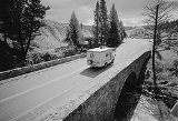
The Grand Loop Road Historic District encompasses the primary road system in Yellowstone National Park
. Much of the 140 miles (225.3 km) system was originally planned by Captain Hiram M. Chittenden
of the US Army Corps of Engineers in the early days of the park, when it was under military administration. The Grand Loop Road provides access to the major features of the park, including the Upper, Midway and Lower
geyser
basins, Mammoth Hot Springs
, Tower Fall, the Grand Canyon of the Yellowstone
and Lake Yellowstone.
A number of other historic districts adjoin the Grand Loop in Yellowstone, including Mammoth Hot Springs
, North Entrance Road
, Roosevelt Lodge
, Lake Fish Hatchery
and Old Faithful
historic districts
.
The Grand Loop Road includes unsigned portions of US 20, US 89, US 191 and US 287, all of which traverse the park. The road was named by Harry W. Frantz
in 1923, who served as the park's publicist before beginning a long career as a journalist.
near Mammoth Hot Springs 44°58′34"N 110°42′2"W, the road travels south, passing through Golden Gate Canyon
on a viaduct and ascending the Gallatin Range
, crossing Kingman Pass
near Bunsen Peak
. From the pass, the road descends into the Gardner River
valley. At the south end of the valley, the road passes Sheepeater Cliff
, a prominent columnar basalt cliff. After crossing the Gardner River, the road follows Obsidian Creek into Obsidian Canyon, passing Obsidian Cliff
about halfway through the canyon. From Obsidian Canyon, the road continues south into the Norris Valley and the Norris Geyser Basin 44°43′38"N 110°41′47"W. Here, the road meets the Gibbon River
and follows it into the Gibbon Geyser Basin and Gibbon Canyon. Emerging from the canyon the Gibbon River merges with the Firehole River
to form the Madison River
. At this point—Madison Junction 44°38′43"N 110°51′29"W, the road junctions with West Entrance Road which follows the Madison River west out of the park and to West Yellowstone, Montana
.
Grand Loop Road continues to follow the Firehole River south and east. In a relatively short distance, the road travels through the three most notable geyser basins in the park: Lower Geyser Basin, Midway Geyser Basin and Upper Geyser Basin. The Old Faithful Historic District is located on the Grand Loop Road adjacent to the Upper Geyser Basin. Turning east from Old Faithful the road crosses the Continental Divide
over Craig Pass
, and descends to the West Thumb Geyser Basin on the shore of Yellowstone Lake. West Thumb 44°24′49"N 110°34′42"W is the southernmost point on the Great Loop road. Here the road junctions with South Entrance Road which continues south to Grand Teton National Park
.
The Grand Loop Road continues north along the shore of Yellowstone Lake. Near the northern end of the lake it passes the Lake Hotel and the Lake Fish Hatchery Historic District
. Just past the Lake Hotel area 44°34′1"N 110°23′11"W, the East Entrance Road turns right and crosses the Yellowstone River
over Fishing Bridge and continues east to Cody, Wyoming
. The Grand Loop Road follows the western side of the Yellowstone River north into the Hayden Valley
and past upper Yellowstone Falls
near the mouth of the Grand Canyon of the Yellowstone
44°44′9"N 110°29′35"W. The road then crosses Dunraven Pass
near Mount Washburn
and descends to Tower Falls
and Tower Junction 44°54′57"N 110°24′56"W where it intersects with the North East Entrance Road to Cooke City, Montana.
From Tower Junction, the road travels north and then west through the Gallatin Range to complete the loop at Mammoth Hot Springs.
Yellowstone National Park
Yellowstone National Park, established by the U.S. Congress and signed into law by President Ulysses S. Grant on March 1, 1872, is a national park located primarily in the U.S. state of Wyoming, although it also extends into Montana and Idaho...
. Much of the 140 miles (225.3 km) system was originally planned by Captain Hiram M. Chittenden
Hiram M. Chittenden
Hiram Martin Chittenden was the Seattle district engineer for the Army Corps of Engineers for whom the Hiram M. Chittenden Locks in Seattle, Washington, were named.-Early Life:...
of the US Army Corps of Engineers in the early days of the park, when it was under military administration. The Grand Loop Road provides access to the major features of the park, including the Upper, Midway and Lower
Geothermal areas of Yellowstone
The geothermal areas of Yellowstone include several geyser basins in Yellowstone National Park as well as other geothermal features such as hot springs, mud pots, and fumaroles...
geyser
Geyser
A geyser is a spring characterized by intermittent discharge of water ejected turbulently and accompanied by a vapour phase . The word geyser comes from Geysir, the name of an erupting spring at Haukadalur, Iceland; that name, in turn, comes from the Icelandic verb geysa, "to gush", the verb...
basins, Mammoth Hot Springs
Mammoth Hot Springs
Mammoth Hot Springs is a large complex of hot springs on a hill of travertine in Yellowstone National Park adjacent to Fort Yellowstone and the Mammoth Hot Springs Historic District. It was created over thousands of years as hot water from the spring cooled and deposited calcium carbonate...
, Tower Fall, the Grand Canyon of the Yellowstone
Grand Canyon of the Yellowstone
The Grand Canyon of the Yellowstone is the first large canyon on the Yellowstone River downstream from Yellowstone Falls in Yellowstone National Park...
and Lake Yellowstone.
A number of other historic districts adjoin the Grand Loop in Yellowstone, including Mammoth Hot Springs
Mammoth Hot Springs Historic District
The Mammoth Hot Springs Historic District in Yellowstone National Park comprises the administrative center for the park. It is composed of two major parts: Fort Yellowstone, the military administrative center for the park in the years immediately following its founding as the world's first...
, North Entrance Road
North Entrance Road Historic District
The North Entrance Road Historic District comprises Yellowstone National Park's North Entrance Road from Gardiner, Montana to the park headquarters at Mammoth Hot Springs, Wyoming, a distance of a little over five miles . The North Entrance Road was the first major road in the park, necessary to...
, Roosevelt Lodge
Roosevelt Lodge Historic District
The Roosevelt Lodge Historic District comprises the area around the Roosevelt Lodge in the northern part of Yellowstone National Park, near Tower Junction. The district includes 143 buildings ranging in size from cabins to the Lodge, built beginning in 1919. The Lodge was first conceived as a field...
, Lake Fish Hatchery
Lake Fish Hatchery Historic District
The Lake Fish Hatchery Historic District comprises nine buildings built between 1930 and 1932 by the U.S. Fish and Wildlife Service in the National Park Service Rustic style. The buildings exhibit a consistency of style and construction, with exposed gable trusses and oversized paired logs at the...
and Old Faithful
Old Faithful Historic District
The Old Faithful Historic District in Yellowstone National Park comprises the built-up portion of the Upper Geyser Basin surrounding the Old Faithful Inn and Old Faithful Geyser...
historic districts
National Register of Historic Places
The National Register of Historic Places is the United States government's official list of districts, sites, buildings, structures, and objects deemed worthy of preservation...
.
The Grand Loop Road includes unsigned portions of US 20, US 89, US 191 and US 287, all of which traverse the park. The road was named by Harry W. Frantz
Harry W. Frantz
Harry W. Frantz was an international editor and correspondent for the Washington Bureau of United Press International for more than four decades.-Early career:...
in 1923, who served as the park's publicist before beginning a long career as a journalist.
Route
Beginning at the junction of the North Entrance Road and Grand Loop Road at Yellowstone National Park headquarters at Fort YellowstoneFort Yellowstone
-See also:* Grand Loop Road Historic District* Lake Fish Hatchery Historic District* Mammoth Hot Springs Historic District* North Entrance Road Historic District* Roosevelt Lodge Historic District* Old Faithful Historic District* US Post Office-Yellowstone Main...
near Mammoth Hot Springs 44°58′34"N 110°42′2"W, the road travels south, passing through Golden Gate Canyon
Golden Gate Canyon
Golden Gate Canyon is in the northwestern region of Yellowstone National Park in the U.S. state of Wyoming. Glen Creek flows north through the canyon enroute to the Gardner River descending from at Kingman Pass to just under in less than...
on a viaduct and ascending the Gallatin Range
Gallatin Range
The Gallatin Range is located in the U.S. states of Montana and Wyoming and includes more than 10 mountains over . The highest peak in the range is Electric Peak at . The Gallatin Range was named after Albert Gallatin, the longest-serving US Secretary of the Treasury and one of the negotiators of...
, crossing Kingman Pass
Kingman Pass
Kingman Pass el. is a mountain pass between Terrance Mountain and Bunsen Peak on the Grand Loop Road , just south of Mammoth Hot Springs in Yellowstone National Park. The pass is named for Lieutenant Dan Christie Kingman of the U.S. Army Corps of Engineers. Kingman rebuilt this difficult portion...
near Bunsen Peak
Bunsen Peak
Bunsen Peak el. is a prominent peak due south of Mammoth Hot Springs in Yellowstone National Park, Wyoming. The peak lies on the east flank of Kingman Pass on the Mammoth to Norris section of the Grand Loop Road. The peak was first ascended by Ferdinand V. Hayden and Captain John W. Barlow in...
. From the pass, the road descends into the Gardner River
Gardner River
The Gardner River is a tributary of the Yellowstone River, approximately long, in northwestern Wyoming and south central Montana in the United States. The entire river is located within Yellowstone National Park...
valley. At the south end of the valley, the road passes Sheepeater Cliff
Sheepeater Cliff
The Sheepeater Cliffs are a series of exposed cliffs made up of columnar basalt in Yellowstone National Park in the United States. The lava was deposited about 500,000 years ago during one of the periodic basaltic floods in Yellowstone Caldera, and later exposed by the Gardner River...
, a prominent columnar basalt cliff. After crossing the Gardner River, the road follows Obsidian Creek into Obsidian Canyon, passing Obsidian Cliff
Obsidian Cliff
Obsidian Cliff, also known as 48YE433, was an important source of lithic materials for prehistoric peoples in Yellowstone National Park near Gardiner, Montana. The cliff was named by Philetus Norris, the second park superintendent in 1878. It was declared a National Historic Landmark in 1996.The...
about halfway through the canyon. From Obsidian Canyon, the road continues south into the Norris Valley and the Norris Geyser Basin 44°43′38"N 110°41′47"W. Here, the road meets the Gibbon River
Gibbon River
The Gibbon River is a river in Yellowstone National Park, in Wyoming, the United States. It rises in the center of the park at Grebe Lake. It flows for a short distance into Wolf Lake. Below Wolf Lake, the river flows through Virginia Cascades into the Norris valley. It flows near the Norris...
and follows it into the Gibbon Geyser Basin and Gibbon Canyon. Emerging from the canyon the Gibbon River merges with the Firehole River
Firehole River
The Firehole River is one of two major tributaries of the Madison River. It flows north approximately from its source in Madison Lake on the Continental Divide to join the Gibbon River at Madison Junction in Yellowstone National Park...
to form the Madison River
Madison River
The Madison River is a headwater tributary of the Missouri River, approximately 183 miles long, in Wyoming and Montana. Its confluence with the Jefferson and Gallatin rivers near Three Forks, Montana form the Missouri River....
. At this point—Madison Junction 44°38′43"N 110°51′29"W, the road junctions with West Entrance Road which follows the Madison River west out of the park and to West Yellowstone, Montana
West Yellowstone, Montana
West Yellowstone is a town in Gallatin County, Montana, adjacent to Yellowstone National Park. The population was 1,177 at the 2000 census. The town is served by Yellowstone Airport...
.
Grand Loop Road continues to follow the Firehole River south and east. In a relatively short distance, the road travels through the three most notable geyser basins in the park: Lower Geyser Basin, Midway Geyser Basin and Upper Geyser Basin. The Old Faithful Historic District is located on the Grand Loop Road adjacent to the Upper Geyser Basin. Turning east from Old Faithful the road crosses the Continental Divide
Continental Divide
The Continental Divide of the Americas, or merely the Continental Gulf of Division or Great Divide, is the name given to the principal, and largely mountainous, hydrological divide of the Americas that separates the watersheds that drain into the Pacific Ocean from those river systems that drain...
over Craig Pass
Craig Pass
Craig Pass , is a mountain pass located on the Continental Divide in Yellowstone National Park in Wyoming. The Grand Loop Road crosses the pass approximately east of Old Faithful Geyser....
, and descends to the West Thumb Geyser Basin on the shore of Yellowstone Lake. West Thumb 44°24′49"N 110°34′42"W is the southernmost point on the Great Loop road. Here the road junctions with South Entrance Road which continues south to Grand Teton National Park
Grand Teton National Park
Grand Teton National Park is a United States National Park located in northwestern Wyoming, U.S. The Park consists of approximately and includes the major peaks of the long Teton Range as well as most of the northern sections of the valley known as Jackson Hole. Only south of Yellowstone...
.
The Grand Loop Road continues north along the shore of Yellowstone Lake. Near the northern end of the lake it passes the Lake Hotel and the Lake Fish Hatchery Historic District
Lake Fish Hatchery Historic District
The Lake Fish Hatchery Historic District comprises nine buildings built between 1930 and 1932 by the U.S. Fish and Wildlife Service in the National Park Service Rustic style. The buildings exhibit a consistency of style and construction, with exposed gable trusses and oversized paired logs at the...
. Just past the Lake Hotel area 44°34′1"N 110°23′11"W, the East Entrance Road turns right and crosses the Yellowstone River
Yellowstone River
The Yellowstone River is a tributary of the Missouri River, approximately long, in the western United States. Considered the principal tributary of the upper Missouri, the river and its tributaries drain a wide area stretching from the Rocky Mountains in the vicinity of the Yellowstone National...
over Fishing Bridge and continues east to Cody, Wyoming
Cody, Wyoming
Cody is a city in Park County, Wyoming, United States. It is named after William Frederick Cody, primarily known as Buffalo Bill, from William Cody's part in the creation of the original town. The population was 9,520 at the 2010 census...
. The Grand Loop Road follows the western side of the Yellowstone River north into the Hayden Valley
Hayden Valley
Hayden Valley is a large, sub-alpine valley in Yellowstone National Park straddling the Yellowstone River between Yellowstone Falls and Yellowstone Lake. The valley floor along the river is an ancient lake bed from a time when Yellowstone Lake was much larger...
and past upper Yellowstone Falls
Yellowstone Falls
Yellowstone Falls consist of two major waterfalls on the Yellowstone River, within Yellowstone National Park, Wyoming, United States. As the Yellowstone river flows north from Yellowstone Lake, it leaves the Hayden Valley and plunges first over Upper Yellowstone Falls and then a quarter mile ...
near the mouth of the Grand Canyon of the Yellowstone
Grand Canyon of the Yellowstone
The Grand Canyon of the Yellowstone is the first large canyon on the Yellowstone River downstream from Yellowstone Falls in Yellowstone National Park...
44°44′9"N 110°29′35"W. The road then crosses Dunraven Pass
Dunraven Pass
Dunraven Pass is a mountain pass on the Grand Loop Road between Tower and Canyon in Yellowstone National Park, Wyoming.-History:In 1874, just two years after the park's creation, the Earl of Dunraven, a titled Irish Peer made a visit to Yellowstone in conjunction with a hunting expedition to the...
near Mount Washburn
Mount Washburn
Mount Washburn el. is a prominent mountain peak in the Washburn Range in Yellowstone National Park, Wyoming. The peak was named in 1870 to honor Henry D. Washburn, leader of the Washburn–Langford–Doane Expedition...
and descends to Tower Falls
Tower Falls
Tower Fall is a waterfall in the northeastern region of Yellowstone National Park, in the U.S. state of Wyoming. On Tower Creek, approximately 1000 yards upstream from the creek's confluence with the Yellowstone River, the fall drops 132 feet and the naming comes from the rock pinnacles at...
and Tower Junction 44°54′57"N 110°24′56"W where it intersects with the North East Entrance Road to Cooke City, Montana.
From Tower Junction, the road travels north and then west through the Gallatin Range to complete the loop at Mammoth Hot Springs.
See also
- Fort YellowstoneFort Yellowstone-See also:* Grand Loop Road Historic District* Lake Fish Hatchery Historic District* Mammoth Hot Springs Historic District* North Entrance Road Historic District* Roosevelt Lodge Historic District* Old Faithful Historic District* US Post Office-Yellowstone Main...
- Lake Fish Hatchery Historic DistrictLake Fish Hatchery Historic DistrictThe Lake Fish Hatchery Historic District comprises nine buildings built between 1930 and 1932 by the U.S. Fish and Wildlife Service in the National Park Service Rustic style. The buildings exhibit a consistency of style and construction, with exposed gable trusses and oversized paired logs at the...
- Mammoth Hot Springs Historic DistrictMammoth Hot Springs Historic DistrictThe Mammoth Hot Springs Historic District in Yellowstone National Park comprises the administrative center for the park. It is composed of two major parts: Fort Yellowstone, the military administrative center for the park in the years immediately following its founding as the world's first...
- North Entrance Road Historic DistrictNorth Entrance Road Historic DistrictThe North Entrance Road Historic District comprises Yellowstone National Park's North Entrance Road from Gardiner, Montana to the park headquarters at Mammoth Hot Springs, Wyoming, a distance of a little over five miles . The North Entrance Road was the first major road in the park, necessary to...
- Roosevelt Lodge Historic DistrictRoosevelt Lodge Historic DistrictThe Roosevelt Lodge Historic District comprises the area around the Roosevelt Lodge in the northern part of Yellowstone National Park, near Tower Junction. The district includes 143 buildings ranging in size from cabins to the Lodge, built beginning in 1919. The Lodge was first conceived as a field...
- Old Faithful Historic DistrictOld Faithful Historic DistrictThe Old Faithful Historic District in Yellowstone National Park comprises the built-up portion of the Upper Geyser Basin surrounding the Old Faithful Inn and Old Faithful Geyser...
External links
- Yellowstone Roads & Bridges, Yellowstone National Park, Teton County, WY: 12 drawings, 86 photo, 255 data pages, 7 photo caption pages, at Historic American Building Survey
- Grand Loop Road Historic District at the Wyoming State Historic Preservation Office