
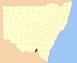
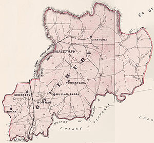
Goulburn County, New South Wales
Encyclopedia
Cadastral divisions of New South Wales
Lands administrative divisions of New South Wales refers to the 141 counties within the Australian state of New South Wales, which are further subdivided into 7,459 parishes. There are also three Land Divisions, around 100 Land Districts, and several other types of districts as well as land boards...
. It contains the city of Albury
Albury, New South Wales
Albury is a major regional city in New South Wales, Australia, located on the Hume Highway on the northern side of the Murray River. It is located wholly within the boundaries of the City of Albury Local Government Area...
, and the towns of Jindera
Jindera, New South Wales
Jindera is a town in the southern Riverina region of New South Wales, Australia. The town is situated north of the regional centre of Albury, in the Greater Hume Shire Local government area...
, Bowna
Bowna, New South Wales
Bowna is a community in the south east part of the Riverina. It is situated by road, about 7 kilometres south west from Mullengandra and 18 kilometres east from Table Top....
and Woomargama
Woomargama, New South Wales
Woomargama is a picturesque village community in the south east part of the Riverina, in the foothills of the great dividing range. It is situated by road, about north-east from Mullengandra and south-west from Holbrook...
.
Goulburn County was named in honour of the statesman, Henry Goulburn
Henry Goulburn
Henry Goulburn PC FRS was an English Conservative statesman and a member of the Peelite faction after 1846.-Background and education:...
(1784-1856).
Parishes within this county
A full list of parishes found within this county; their current LGA and mapping coordinates to the approximate centre of each location is as follows:| Parish | LGA | Coordinates |
|---|---|---|
| Albury Albury, New South Wales Albury is a major regional city in New South Wales, Australia, located on the Hume Highway on the northern side of the Murray River. It is located wholly within the boundaries of the City of Albury Local Government Area... |
City of Albury City of Albury The City of Albury is a Local Government Area in the Riverina region of New South Wales, Australia. The LGA covers the entirety of the Albury urban area including the suburbs of Forrest Hill, Lavington, Thurgoona, Splitters Creek, Ettamogah, Bowna, Table Top and Wirlinga.The LGA is administered... |
36°02′54"S 146°54′04"E |
| Back Creek | Greater Hume Shire Council Greater Hume Shire Council Greater Hume Shire Council is a Local Government Area of New South Wales, Australia. The Council was formed in 2004 incorporating Culcairn Shire, the majority of Holbrook Shire and part of Hume Shire.... |
35°37′54"S 147°21′04"E |
| Billabung | Greater Hume Shire Council Greater Hume Shire Council Greater Hume Shire Council is a Local Government Area of New South Wales, Australia. The Council was formed in 2004 incorporating Culcairn Shire, the majority of Holbrook Shire and part of Hume Shire.... |
35°37′54"S 147°30′04"E |
| Bowna Bowna, New South Wales Bowna is a community in the south east part of the Riverina. It is situated by road, about 7 kilometres south west from Mullengandra and 18 kilometres east from Table Top.... |
Greater Hume Shire Council Greater Hume Shire Council Greater Hume Shire Council is a Local Government Area of New South Wales, Australia. The Council was formed in 2004 incorporating Culcairn Shire, the majority of Holbrook Shire and part of Hume Shire.... |
35°59′54"S 146°03′04"E |
| Carabobala | Greater Hume Shire Council Greater Hume Shire Council Greater Hume Shire Council is a Local Government Area of New South Wales, Australia. The Council was formed in 2004 incorporating Culcairn Shire, the majority of Holbrook Shire and part of Hume Shire.... |
35°40′54"S 147°15′04"E |
| Carabost Carabost, New South Wales Carabost is a foresting community in the south east part of the Riverina. It is situated about 16 kilometres north west from Rosewood and 22 kilometres south east from Kyeamba.thumb|200px|left|Facilities at Carabost... |
Greater Hume Shire Council Greater Hume Shire Council Greater Hume Shire Council is a Local Government Area of New South Wales, Australia. The Council was formed in 2004 incorporating Culcairn Shire, the majority of Holbrook Shire and part of Hume Shire.... |
35°35′54"S 147°33′04"E |
| Coocook | Greater Hume Shire Council Greater Hume Shire Council Greater Hume Shire Council is a Local Government Area of New South Wales, Australia. The Council was formed in 2004 incorporating Culcairn Shire, the majority of Holbrook Shire and part of Hume Shire.... |
35°43′54"S 147°33′04"E |
| Cookardinia Cookardinia, New South Wales Cookardinia is a small and almost non-existent village 24km east of Henty. Its surrounding area has an approximate population of 283 persons.... |
Greater Hume Shire Council Greater Hume Shire Council Greater Hume Shire Council is a Local Government Area of New South Wales, Australia. The Council was formed in 2004 incorporating Culcairn Shire, the majority of Holbrook Shire and part of Hume Shire.... |
35°35′54"S 147°15′04"E |
| Coppabella | Greater Hume Shire Council Greater Hume Shire Council Greater Hume Shire Council is a Local Government Area of New South Wales, Australia. The Council was formed in 2004 incorporating Culcairn Shire, the majority of Holbrook Shire and part of Hume Shire.... |
35°44′54"S 147°42′04"E |
| Cumboroona | Greater Hume Shire Council Greater Hume Shire Council Greater Hume Shire Council is a Local Government Area of New South Wales, Australia. The Council was formed in 2004 incorporating Culcairn Shire, the majority of Holbrook Shire and part of Hume Shire.... |
35°58′54"S 147°12′04"E |
| Currajong | Greater Hume Shire Council Greater Hume Shire Council Greater Hume Shire Council is a Local Government Area of New South Wales, Australia. The Council was formed in 2004 incorporating Culcairn Shire, the majority of Holbrook Shire and part of Hume Shire.... |
35°50′54"S 147°38′04"E |
| Dora Dora | Greater Hume Shire Council Greater Hume Shire Council Greater Hume Shire Council is a Local Government Area of New South Wales, Australia. The Council was formed in 2004 incorporating Culcairn Shire, the majority of Holbrook Shire and part of Hume Shire.... |
35°51′54"S 147°23′04"E |
| Forest Creek | Greater Hume Shire Council Greater Hume Shire Council Greater Hume Shire Council is a Local Government Area of New South Wales, Australia. The Council was formed in 2004 incorporating Culcairn Shire, the majority of Holbrook Shire and part of Hume Shire.... |
35°34′54"S 147°30′04"E |
| Gerogery Gerogery, New South Wales Gerogery is a small village in Greater Hume Shire Council in the state of New South Wales, Australia. Gerogery serves a rural farming community. The village is located on the Main South railway line between Sydney and Melbourne, where it intersects with the Olympic Way. At the 2006 census,... |
Greater Hume Shire Council Greater Hume Shire Council Greater Hume Shire Council is a Local Government Area of New South Wales, Australia. The Council was formed in 2004 incorporating Culcairn Shire, the majority of Holbrook Shire and part of Hume Shire.... |
35°52′24"S 147°01′04"E |
| Holbrook Holbrook, New South Wales Holbrook is a small town in Southern New South Wales, Australia. It is on the Hume Highway, 356 km North-East of Melbourne and 491 km south-west of Sydney between Tarcutta and Albury. The town is in the Greater Hume Shire Council area which was established in May 2004 from the merger of... |
Greater Hume Shire Council Greater Hume Shire Council Greater Hume Shire Council is a Local Government Area of New South Wales, Australia. The Council was formed in 2004 incorporating Culcairn Shire, the majority of Holbrook Shire and part of Hume Shire.... |
35°42′54"S 147°20′04"E |
| Hume | Greater Hume Shire Council Greater Hume Shire Council Greater Hume Shire Council is a Local Government Area of New South Wales, Australia. The Council was formed in 2004 incorporating Culcairn Shire, the majority of Holbrook Shire and part of Hume Shire.... |
35°52′54"S 147°15′04"E |
| Huon | Greater Hume Shire Council Greater Hume Shire Council Greater Hume Shire Council is a Local Government Area of New South Wales, Australia. The Council was formed in 2004 incorporating Culcairn Shire, the majority of Holbrook Shire and part of Hume Shire.... |
35°52′54"S 146°55′04"E |
| Jergyle | Greater Hume Shire Council Greater Hume Shire Council Greater Hume Shire Council is a Local Government Area of New South Wales, Australia. The Council was formed in 2004 incorporating Culcairn Shire, the majority of Holbrook Shire and part of Hume Shire.... |
35°48′54"S 147°23′04"E |
| Jerra Jerra | Greater Hume Shire Council Greater Hume Shire Council Greater Hume Shire Council is a Local Government Area of New South Wales, Australia. The Council was formed in 2004 incorporating Culcairn Shire, the majority of Holbrook Shire and part of Hume Shire.... |
35°28′54"S 147°13′04"E |
| Jindera Jindera, New South Wales Jindera is a town in the southern Riverina region of New South Wales, Australia. The town is situated north of the regional centre of Albury, in the Greater Hume Shire Local government area... |
Greater Hume Shire Council Greater Hume Shire Council Greater Hume Shire Council is a Local Government Area of New South Wales, Australia. The Council was formed in 2004 incorporating Culcairn Shire, the majority of Holbrook Shire and part of Hume Shire.... |
35°57′54"S 146°55′04"E |
| Jingellic Jingellic, New South Wales Jingellic is a small town that straddles the boundaries of the Greater Hume Shire and Tumbarumba Shire Local Government Areas in southern New South Wales, Australia... |
Greater Hume Shire Council Greater Hume Shire Council Greater Hume Shire Council is a Local Government Area of New South Wales, Australia. The Council was formed in 2004 incorporating Culcairn Shire, the majority of Holbrook Shire and part of Hume Shire.... |
35°54′54"S 147°39′04"E |
| Little Billabung Little Billabong, New South Wales Little Billabong is a village community in the central part of the Riverina. It is situated by road, about 17 kilometres west from Kyeamba and 26 kilometres east from Holbrook. At the 2006 census, Little Billabong had a population of 466 people.... |
Greater Hume Shire Council Greater Hume Shire Council Greater Hume Shire Council is a Local Government Area of New South Wales, Australia. The Council was formed in 2004 incorporating Culcairn Shire, the majority of Holbrook Shire and part of Hume Shire.... |
35°29′54"S 147°31′04"E |
| Mitchell | Greater Hume Shire Council Greater Hume Shire Council Greater Hume Shire Council is a Local Government Area of New South Wales, Australia. The Council was formed in 2004 incorporating Culcairn Shire, the majority of Holbrook Shire and part of Hume Shire.... |
35°47′54"S 147°18′04"E |
| Mountain Creek | Greater Hume Shire Council Greater Hume Shire Council Greater Hume Shire Council is a Local Government Area of New South Wales, Australia. The Council was formed in 2004 incorporating Culcairn Shire, the majority of Holbrook Shire and part of Hume Shire.... |
35°46′54"S 147°15′04"E |
| Mullengandra Mullengandra, New South Wales Mullengandra is a village community in the south east part of the Riverina. It is situated by road, about 7 kilometres north east from Bowna and 8 kilometres south west from Woomargama.Mullengandra Post Office opened on 16 May 1888.... |
Greater Hume Shire Council Greater Hume Shire Council Greater Hume Shire Council is a Local Government Area of New South Wales, Australia. The Council was formed in 2004 incorporating Culcairn Shire, the majority of Holbrook Shire and part of Hume Shire.... |
35°53′54"S 147°11′04"E |
| Mungabarina | Greater Hume Shire Council Greater Hume Shire Council Greater Hume Shire Council is a Local Government Area of New South Wales, Australia. The Council was formed in 2004 incorporating Culcairn Shire, the majority of Holbrook Shire and part of Hume Shire.... |
35°01′54"S 146°57′04"E |
| Murray | Greater Hume Shire Council Greater Hume Shire Council Greater Hume Shire Council is a Local Government Area of New South Wales, Australia. The Council was formed in 2004 incorporating Culcairn Shire, the majority of Holbrook Shire and part of Hume Shire.... |
35°37′24"S 147°32′04"E |
| Narra Narra Wa | Greater Hume Shire Council Greater Hume Shire Council Greater Hume Shire Council is a Local Government Area of New South Wales, Australia. The Council was formed in 2004 incorporating Culcairn Shire, the majority of Holbrook Shire and part of Hume Shire.... |
35°47′54"S 147°32′04"E |
| Pulletop Pulletop, New South Wales Pulletop is a rural locality in the south eastern part of the Riverina - it was previously called "Pullitop". It is situated by road, about 5 kilometres east south-east from Burrandana and 9 kilometres north from Westby.-Notes and references:... |
Greater Hume Shire Council Greater Hume Shire Council Greater Hume Shire Council is a Local Government Area of New South Wales, Australia. The Council was formed in 2004 incorporating Culcairn Shire, the majority of Holbrook Shire and part of Hume Shire.... |
35°33′54"S 147°21′04"E |
| Talmalmo Talmalmo, New South Wales Talmalmo is a community in the south east part of the Riverina very close to the border of Victoria, Australia. It is situated by road, about 21 kilometres west from Jingellic and 23 kilometres south west from Wymah.... |
Greater Hume Shire Council Greater Hume Shire Council Greater Hume Shire Council is a Local Government Area of New South Wales, Australia. The Council was formed in 2004 incorporating Culcairn Shire, the majority of Holbrook Shire and part of Hume Shire.... |
35°51′54"S 147°33′04"E |
| Thurgoona Thurgoona, New South Wales Thurgoona is an outer suburb of the regional city of Albury in southern New South Wales, Australia. The suburb is located in the City of Albury Local government area.It is the site of one of the campuses of Charles Sturt University... |
City of Albury City of Albury The City of Albury is a Local Government Area in the Riverina region of New South Wales, Australia. The LGA covers the entirety of the Albury urban area including the suburbs of Forrest Hill, Lavington, Thurgoona, Splitters Creek, Ettamogah, Bowna, Table Top and Wirlinga.The LGA is administered... |
36°03′54"S 147°00′04"E |
| Vautier | Greater Hume Shire Council Greater Hume Shire Council Greater Hume Shire Council is a Local Government Area of New South Wales, Australia. The Council was formed in 2004 incorporating Culcairn Shire, the majority of Holbrook Shire and part of Hume Shire.... |
35°51′54"S 147°30′04"E |
| Wagra | Greater Hume Shire Council Greater Hume Shire Council Greater Hume Shire Council is a Local Government Area of New South Wales, Australia. The Council was formed in 2004 incorporating Culcairn Shire, the majority of Holbrook Shire and part of Hume Shire.... |
35°58′54"S 147°15′04"E |
| Woomargama Woomargama, New South Wales Woomargama is a picturesque village community in the south east part of the Riverina, in the foothills of the great dividing range. It is situated by road, about north-east from Mullengandra and south-west from Holbrook... |
Greater Hume Shire Council Greater Hume Shire Council Greater Hume Shire Council is a Local Government Area of New South Wales, Australia. The Council was formed in 2004 incorporating Culcairn Shire, the majority of Holbrook Shire and part of Hume Shire.... |
35°48′54"S 147°10′04"E |
| Wyndham Wyndham, New South Wales Wyndham is a village located 519 km south of Sydney, on the far south coast of New South Wales, Australia in the Bega Valley Shire. At the 2006 census, Wyndham had a population of 368.Neighboring towns are Bega, Merimbula, Pambula, Candelo and Bombala.... |
Greater Hume Shire Council Greater Hume Shire Council Greater Hume Shire Council is a Local Government Area of New South Wales, Australia. The Council was formed in 2004 incorporating Culcairn Shire, the majority of Holbrook Shire and part of Hume Shire.... |
35°56′54"S 147°07′04"E |
| Yambla | Greater Hume Shire Council Greater Hume Shire Council Greater Hume Shire Council is a Local Government Area of New South Wales, Australia. The Council was formed in 2004 incorporating Culcairn Shire, the majority of Holbrook Shire and part of Hume Shire.... |
35°55′54"S 147°01′04"E |
| Yarara | Greater Hume Shire Council Greater Hume Shire Council Greater Hume Shire Council is a Local Government Area of New South Wales, Australia. The Council was formed in 2004 incorporating Culcairn Shire, the majority of Holbrook Shire and part of Hume Shire.... |
35°41′54"S 147°39′04"E |
| Yarra Yarra | Greater Hume Shire Council Greater Hume Shire Council Greater Hume Shire Council is a Local Government Area of New South Wales, Australia. The Council was formed in 2004 incorporating Culcairn Shire, the majority of Holbrook Shire and part of Hume Shire.... |
35°42′54"S 147°27′04"E |