

Gortnahoo
Encyclopedia
North Tipperary
North Tipperary is a county in Ireland. It is part of the Mid-West Region and is also located in the province of Munster. It is named after the town of Tipperary and consists of 48% of the land area of the traditional county of Tipperary. The county was established in 1898 and has had a county...
, Ireland
Republic of Ireland
Ireland , described as the Republic of Ireland , is a sovereign state in Europe occupying approximately five-sixths of the island of the same name. Its capital is Dublin. Ireland, which had a population of 4.58 million in 2011, is a constitutional republic governed as a parliamentary democracy,...
. It is located on the R689
R689 road
The R689 road is a regional road in Ireland linking Urlingford to Clonmel. It passes through Killenaule and Fethard en route.The road is long.-References:* – Department of Transport...
regional road
Regional road
A regional road in Ireland is a class of road not forming a major route , but nevertheless forming a link in the national route network. There are over 11,600 kilometres of regional roads. Regional roads are numbered with three digit route numbers, prefixed by "R" A regional road in Ireland is a...
6 km (3.7 mi) south of Urlingford
Urlingford
Urlingford is a town in the barony of Galmoy, County Kilkenny, Ireland.The town lies on the R639. The M8 motorway runs just west of the town, from which both Urlingford and nearby Johnstown are accessed via junction four. Urlingford is a bus hub, with major operator JJ Kavanagh and Sons based there...
, County Kilkenny
County Kilkenny
County Kilkenny is a county in Ireland. It is part of the South-East Region and is also located in the province of Leinster. It is named after the city of Kilkenny. The territory of the county was the core part of the ancient Irish Kingdom of Osraige which in turn was the core of the Diocese of...
. It is 3 km (1.9 mi) southeast of the N8 Dublin - Cork
Cork (city)
Cork is the second largest city in the Republic of Ireland and the island of Ireland's third most populous city. It is the principal city and administrative centre of County Cork and the largest city in the province of Munster. Cork has a population of 119,418, while the addition of the suburban...
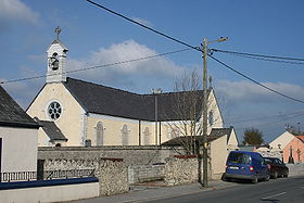
road. Gortnahoe, pronounced "Gurt/na/hoo" by the locals, is part of the united parish of Glegoole-Gortnahoe.
History
When you travel from Gortnahoe to Glengoole you expect to find Glengoole after Ballysloe, but the stranger finds that the sign for the next village reads ‘New Birmingham’. He also finds that the village is neither New nor Birmingham. There must be history here and there is. It takes you back to the beginning of the 19th century, when the local landlord, Vere Hunt, could see great potential for the development of coal mining. The plans were to build a city for coal mining in the Slievardagh Hills. In reality it never got to the stage of full development, so you can find the remains of a gaol, which never held a prisoner and the extensive diary of Vere Hunt, giving a vivid account of how Glengoole got the name New Birmingham, but failed to reach its full potential.It is not the only place in the parish that got its name from another country. In the townslands of New Park and Bawnleigh we have Palatine Street, called after a province in Germany, which now brings us back to the eighteenth century. It was Sir William Barker, the landlord in Kilcooley, who offered protection and property to some families who left the Palatine on the borders of Germany and France, settled in England and later came to New Park and Bawnlea. In the Griffith Valuations of 1850 we find that there was a Methodist Chapel and a Baptist Chapel in that area. Descendants of those families still farm those areas and form an important part of the parish and of the Church of Ireland.
Not far from Palatine Street is the Wellington Monument, with the inscription “Erected in August 1817 in the eightieth year of his age by Sir William Barker, in honour of his grace the duke of Wellington and of his glorious victory over the French at Waterloo on the 15th June 1815.”
When we stop to think about the placing of our parish on the map of Ireland you notice that it is right on the border between Munster and Leinster and it is at the end of the valley, leading from Kilkenny into the plains of Munster, a gap important for control and protection. This may be the reason why we find the ruins of a constabulary barracks at Longford Pass North or Durrihies. We are now going further back into history, because this was very likely the site of the ancient Celtic Monastery of Doire Mor, the monastery established by St. Colmán, which continued with the other Celtic Monasteries of Liath Mór, Doire na Flan and Derryvilla to serve the religious needs of the people.
With the decline of the Celtic Monasteries and the arrival of the Cistercians in Ireland in the 18th century, the Cistercian Monastery of Kilcooley was established by the monks from Jerpoint in 1184. The monastery continued to proper until the disestablishment of the monasteries by King Henry VIII in 1539. During this time there were also the Church centres of Boulick and Fennor. All the townslands were divided between those three parishes.
The magnificent ruins of the monastery of Kilcooley point to its important and the wonderful stonework. A great deal of this work was done by the O’Tunneys, especially the tomb of Pierce Butler of Lismolin and a number of other headstones. The carved slabs of the Crucifixion, the abbot, St. Christopher and the mermaid are tributes to their genius. The beautiful East Window is the reminder of how capable the stonemasons were to be able to design and build what has lasted for so many centuries. The church that was at Ballinalackin in Glengoole was an outchurch from Kilcooley.
Fennor, like Kilcooley and Boulick is mentioned in the Papal Taxation lists of 1291. The Church is dedicated to the Nativity of the Blessed Virgin Mary. When Archbishop James Butler visited the parish in 1752, the church at Fennor does not appear to have been in use. The ruins in Fennor cemetery include the ruins of the Church of Ireland Church and the ruins of the Catholic Church and the residence of the priests together.
In Boulick we have the remains of a motte, Tower house and church. Boulick was an important settlement from earliest times. It was a parish as far back as 1291. The church in Boulick also has a protective tower. When a grave was being dug underneath the tower at the end of the 19th century two bells were found underground. Those bells were given to Archbishop Croke and at the time of the restoration of Holycross Abbey they were hung in the tower of the abbey.
During the 18th century the Penal Laws made it difficult for Catholics to practise their religion and priests were scarce throughout Ireland. The outcome was that in 1743 the parishes of Kilcooley, Boulick and Fennor were amalgamated with Urlingford and Graine. The amalgamation continued until Fr. Michael Meighan became P.P. of Gortanhoe and Glengoole in 1805. It was Fr. Michael Meighan who built a new church in Glengoole in 1815. This was replaced on the same site by the present church which was built in 1976. The present church in Gortnahoe was also built by Fr Michael Meighan in 1820. This Church has undergone extensive renovations in 1923, 1974–75 and most recently in 2008.
School developments have also been very much part of the history of our parish. At the time of Catholic Emancipation in 1829 the government launched a major enquiry into the provision of education and in that report we find that there were twelve schools in the parish, organised and funded in different ways. Nine of them were Roman Catholic Schools and three were Protestant Schools. It was in 1831 that the Board of National Education was established. This marked a big development in the funding of education by the government. Since 1829 there have been many changes and amalgamations, until the present number of schools in the parish is three, Gortnahoe, Ballysloe and Glengoole.
There are many other areas of life that go to make up our history, but we hope this short essay gives some information of interest and value.
See also
- List of towns and villages in Ireland