
Goldendale, Washington
Encyclopedia
Goldendale is a rural agricultural town in and the county seat
of Klickitat County, Washington, United States
, near the Columbia River Gorge. The population within city limits was 3,760 at the 2000 census and 3,407, a 9.4% decrease at the 2010 census. A nationally known point of interest is north of town, Goldendale Observatory State Park
. The valley area in which Goldendale is located has sweeping and dramatic views of the Cascade Range
Mountains 40 mile to west and the Simcoe Hills to the north.
, Lyle
, Bingen
, Glenwood
, Dallesport
and Bickleton
, all still in existence. Goldendale was officially incorporated on November 14, 1879.
Goldendale has remained the employment, business, commercial and banking center for the valley and, as the county seat, is the location for Klickitat County's courts and government offices. In recent years this small community has suffered from severe economic decline. After a local aluminum plant that once employed many residents closed, the small community struggled economically. The loss of tax base has taken its toll on the funds available for maintaining the city's infrastructure. In recent years there has been an interest in installing wind turbines that would generate power. While it has provided some jobs, this industry has not been the economic solution for which many residents hoped.
On June 9, 1918, William Wallace Campbell
, Director of the Lick Observatory
in San Jose, CA, and astronomer Heber Curtis journeyed to Goldendale to view a total eclipse. The purpose of the observation was to photograph the sun's corona and the apparent distorted placement of stars due to the sun's gravitational pull on those star's rays while passing by the sun. Lacking proper equipment and instead only using multiple cameras Campbell and Curtis were unable to confirm stars' deflection. However, by November 1919, their efforts would be vindicated by British astronomers and Einstein's Theory of Relativity
was confirmed.
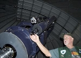
On October 13, 1973 the Goldendale Observatory, the main attraction of the city, was dedicated. It is one of the larger free, public observatories. Because of a relatively small population, Goldendale offers excellent stargazing as well.
In 2008 Goldendale hosted the International Gravity Sports Association's 'Festival of Speed,' on a segment of the historic Maryhill highway.
Goldendale is considered the last true blood mining town in the contiguous 48 states.
Timber cutting, ranching, farming, agriculture are still key industries in the area, but have seen some hard times over the years. Many farms are being sold off and developed by local and non-local investors. Once beautiful farmland is now divided up into residential tracts.
An aluminum reduction plant was built by Harvey Aluminum (later Martin Marietta, forerunner to conglomerate Lockheed Martin) at an industrial site adjacent to the John Day Dam in 1968. The industrial development and resulting jobs brought an era of growth and prosperity to Goldendale for 35 years. This plant added payroll strength and diversity of the timber and agricultural based Goldendale area economy. The aluminum facility with 3 shifts of employment at its peak in the '70s and '80s was employing about 1,400–1,800 people and about 800 in the years from 1990–2003. The facility had been awarded a large allotment of low cost power from the hydro electric dam system that was nearby, with the assumption this would encourage industrial development and create jobs and resulting economic development. In 2003, the aluminum smelter closed operations. Reasons cited were high electricity costs and low world prices for aluminum. Many of the workers moved while others remained while they went back to school and retrained for other occupations. The closing of the aluminum plant caused serious economic stress in the area.
At this time Rabanco Regional Disposal is the largest single employer of residents in the Goldendale area.
& a contemporary architectural construction by Portland based firm Allied Works Architecture, and a life-size cement replica of stonehenge situated ten minutes south of Goldendale. The replica, completed in 1930, is a memorial of those who died in World War I.
In downtown Goldendale, the Presby Mansion, now the Presby Museum, is also a tourist attraction and houses the Klickitat County Historical Society.
According to the United States Census Bureau
, the city has a total area of 2.4 square miles (6.2 km²), all of it land.
Goldendale's elevation at the County Courthouse is 498 meters (1636 feet).
The Little Klickitat River flows roughly east-to-west across the northern portion of the city. Bloodgood Creek, an entirely spring-fed year-round water source, runs through the northwest part of town and intersects with the Little Klickitat just west of the city. Both are sources of rainbow trout as well as being home to waterfowl such as the great blue heron and several species of duck. Bloodgood Creek provides a portion of Goldendale's drinking water and is capped at the source for that purpose.
US Highway 97 runs along the eastern boundary of the city and connects Goldendale with Interstate 84, 21 km (13 mi) south in the state of Oregon and State Route 14, which is 19 km (11.8 mi) south and runs along the Washington side of the Columbia River. State Route 142 creates a major east-west route through Goldendale, beginning at US 97 on the north end of town.
Goldendale has started to receive much of the wind turbine business, as major companies buy land and build around the town.
of 2000, there were 3,760 people, 1,515 households, and 963 families residing in the city. The population density
was 1,592.6 people per square mile (615.1/km²). There were 1,690 housing units at an average density of 715.8 per square mile (276.5/km²). The racial makeup of the city was 87.42% White, 0.21% African American, 4.63% Native American, 0.72% Asian, 0.27% Pacific Islander, 4.07% from other races
, and 2.69% from two or more races. Hispanic or Latino of any race were 5.85% of the population.
There were 1,515 households out of which 34.4% had children under the age of 18 living with them, 46.4% were married couples
living together, 12.7% had a female householder with no husband present, and 36.4% were non-families. 31.3% of all households were made up of individuals and 14.1% had someone living alone who was 65 years of age or older. The average household size was 2.41 and the average family size was 3.02.
In the city the population was spread out with 28.4% under the age of 18, 7.7% from 18 to 24, 26.1% from 25 to 44, 22.6% from 45 to 64, and 15.2% who were 65 years of age or older. The median age was 36 years. For every 100 females there were 90.6 males. For every 100 females age 18 and over, there were 89.4 males.
The median income for a household in the city was $26,030, and the median income for a family was $33,866. Males had a median income of $36,977 versus $22,289 for females. The per capita income
for the city was $13,111. About 21.9% of families and 25.4% of the population were below the poverty line, including 30.5% of those under age 18 and 26.3% of those age 65 or over.
County seat
A county seat is an administrative center, or seat of government, for a county or civil parish. The term is primarily used in the United States....
of Klickitat County, Washington, United States
United States
The United States of America is a federal constitutional republic comprising fifty states and a federal district...
, near the Columbia River Gorge. The population within city limits was 3,760 at the 2000 census and 3,407, a 9.4% decrease at the 2010 census. A nationally known point of interest is north of town, Goldendale Observatory State Park
Goldendale Observatory State Park
Goldendale Observatory State Park is an educational facility near Goldendale, Washington. It was acquired by the state of Washington in 1980, after being operated by the Goldendale Observatory Corporation since October 13, 1973....
. The valley area in which Goldendale is located has sweeping and dramatic views of the Cascade Range
Cascade Range
The Cascade Range is a major mountain range of western North America, extending from southern British Columbia through Washington and Oregon to Northern California. It includes both non-volcanic mountains, such as the North Cascades, and the notable volcanoes known as the High Cascades...
Mountains 40 mile to west and the Simcoe Hills to the north.
History
In 1872 the town was given its name by the early homesteader John Golden. The Golden House is still viewable at Columbus and Collins St. in downtown Goldendale. In 1878 Goldendale became the county seat. Other early towns in the county were White SalmonWhite Salmon, Washington
White Salmon is a city in Klickitat County, Washington, United States. It is located in the Columbia River Gorge. The population was 2,193 at the 2000 census and increased 1.4% to 2,224 at the 2010 census.-History:...
, Lyle
Lyle, Washington
Lyle is a census-designated place in Klickitat County, Washington, United States. The population was 530 at the 2000 census.- History :...
, Bingen
Bingen, Washington
Bingen is a city in Klickitat County, Washington, United States. The population was 712 at the 2010 census, a 6% increase over the 2000 census.-History:Bingen was founded by P.J. Suksdorf in 1892, and named by him for Bingen am Rhein in Germany...
, Glenwood
Glenwood, Klickitat County, Washington
Glenwood is an unincorporated community in Klickitat County, Washington, United States. Glenwood is west-northwest of Goldendale. Glenwood has a post office with ZIP code 98619....
, Dallesport
Dallesport, Washington
Dallesport is a census-designated place in Klickitat County, Washington, United States. The population was 1,202 at the 2010 census.-History:...
and Bickleton
Bickleton, Washington
Bickleton is a census-designated place in Klickitat County, Washington, United States. Bickleton was first settled in 1879 by Charles N. Bickle...
, all still in existence. Goldendale was officially incorporated on November 14, 1879.
Goldendale has remained the employment, business, commercial and banking center for the valley and, as the county seat, is the location for Klickitat County's courts and government offices. In recent years this small community has suffered from severe economic decline. After a local aluminum plant that once employed many residents closed, the small community struggled economically. The loss of tax base has taken its toll on the funds available for maintaining the city's infrastructure. In recent years there has been an interest in installing wind turbines that would generate power. While it has provided some jobs, this industry has not been the economic solution for which many residents hoped.
On June 9, 1918, William Wallace Campbell
William Wallace Campbell
William Wallace Campbell was an American astronomer, and director of Lick Observatory from 1900 to 1930. He specialized in spectroscopy.-Biography:...
, Director of the Lick Observatory
Lick Observatory
The Lick Observatory is an astronomical observatory, owned and operated by the University of California. It is situated on the summit of Mount Hamilton, in the Diablo Range just east of San Jose, California, USA...
in San Jose, CA, and astronomer Heber Curtis journeyed to Goldendale to view a total eclipse. The purpose of the observation was to photograph the sun's corona and the apparent distorted placement of stars due to the sun's gravitational pull on those star's rays while passing by the sun. Lacking proper equipment and instead only using multiple cameras Campbell and Curtis were unable to confirm stars' deflection. However, by November 1919, their efforts would be vindicated by British astronomers and Einstein's Theory of Relativity
Theory of relativity
The theory of relativity, or simply relativity, encompasses two theories of Albert Einstein: special relativity and general relativity. However, the word relativity is sometimes used in reference to Galilean invariance....
was confirmed.
On October 13, 1973 the Goldendale Observatory, the main attraction of the city, was dedicated. It is one of the larger free, public observatories. Because of a relatively small population, Goldendale offers excellent stargazing as well.
In 2008 Goldendale hosted the International Gravity Sports Association's 'Festival of Speed,' on a segment of the historic Maryhill highway.
Goldendale is considered the last true blood mining town in the contiguous 48 states.
Industry
A lumber mill and logging used to be major industries in the area but have since ceased to exist.Timber cutting, ranching, farming, agriculture are still key industries in the area, but have seen some hard times over the years. Many farms are being sold off and developed by local and non-local investors. Once beautiful farmland is now divided up into residential tracts.
An aluminum reduction plant was built by Harvey Aluminum (later Martin Marietta, forerunner to conglomerate Lockheed Martin) at an industrial site adjacent to the John Day Dam in 1968. The industrial development and resulting jobs brought an era of growth and prosperity to Goldendale for 35 years. This plant added payroll strength and diversity of the timber and agricultural based Goldendale area economy. The aluminum facility with 3 shifts of employment at its peak in the '70s and '80s was employing about 1,400–1,800 people and about 800 in the years from 1990–2003. The facility had been awarded a large allotment of low cost power from the hydro electric dam system that was nearby, with the assumption this would encourage industrial development and create jobs and resulting economic development. In 2003, the aluminum smelter closed operations. Reasons cited were high electricity costs and low world prices for aluminum. Many of the workers moved while others remained while they went back to school and retrained for other occupations. The closing of the aluminum plant caused serious economic stress in the area.
At this time Rabanco Regional Disposal is the largest single employer of residents in the Goldendale area.
Culture
Goldendale has many annual civic activities including the Klickitat County Fair & Rodeo, the Goldendale Community Days, held on the Goldendale Courthouse lawn, and holiday parades.Tourism
Goldendale's tourist attractions include the Goldendale Observatory, the nearby Maryhill Museum with a collection of 87 works by Auguste RodinAuguste Rodin
François-Auguste-René Rodin , known as Auguste Rodin , was a French sculptor. Although Rodin is generally considered the progenitor of modern sculpture, he did not set out to rebel against the past...
& a contemporary architectural construction by Portland based firm Allied Works Architecture, and a life-size cement replica of stonehenge situated ten minutes south of Goldendale. The replica, completed in 1930, is a memorial of those who died in World War I.
In downtown Goldendale, the Presby Mansion, now the Presby Museum, is also a tourist attraction and houses the Klickitat County Historical Society.
Geography
Goldendale is located at 45°49′16"N 120°49′17"W (45.821117, -120.821380).According to the United States Census Bureau
United States Census Bureau
The United States Census Bureau is the government agency that is responsible for the United States Census. It also gathers other national demographic and economic data...
, the city has a total area of 2.4 square miles (6.2 km²), all of it land.
Goldendale's elevation at the County Courthouse is 498 meters (1636 feet).
The Little Klickitat River flows roughly east-to-west across the northern portion of the city. Bloodgood Creek, an entirely spring-fed year-round water source, runs through the northwest part of town and intersects with the Little Klickitat just west of the city. Both are sources of rainbow trout as well as being home to waterfowl such as the great blue heron and several species of duck. Bloodgood Creek provides a portion of Goldendale's drinking water and is capped at the source for that purpose.
US Highway 97 runs along the eastern boundary of the city and connects Goldendale with Interstate 84, 21 km (13 mi) south in the state of Oregon and State Route 14, which is 19 km (11.8 mi) south and runs along the Washington side of the Columbia River. State Route 142 creates a major east-west route through Goldendale, beginning at US 97 on the north end of town.
Goldendale has started to receive much of the wind turbine business, as major companies buy land and build around the town.
Demographics
As of the censusCensus
A census is the procedure of systematically acquiring and recording information about the members of a given population. It is a regularly occurring and official count of a particular population. The term is used mostly in connection with national population and housing censuses; other common...
of 2000, there were 3,760 people, 1,515 households, and 963 families residing in the city. The population density
Population density
Population density is a measurement of population per unit area or unit volume. It is frequently applied to living organisms, and particularly to humans...
was 1,592.6 people per square mile (615.1/km²). There were 1,690 housing units at an average density of 715.8 per square mile (276.5/km²). The racial makeup of the city was 87.42% White, 0.21% African American, 4.63% Native American, 0.72% Asian, 0.27% Pacific Islander, 4.07% from other races
Race (United States Census)
Race and ethnicity in the United States Census, as defined by the Federal Office of Management and Budget and the United States Census Bureau, are self-identification data items in which residents choose the race or races with which they most closely identify, and indicate whether or not they are...
, and 2.69% from two or more races. Hispanic or Latino of any race were 5.85% of the population.
There were 1,515 households out of which 34.4% had children under the age of 18 living with them, 46.4% were married couples
Marriage
Marriage is a social union or legal contract between people that creates kinship. It is an institution in which interpersonal relationships, usually intimate and sexual, are acknowledged in a variety of ways, depending on the culture or subculture in which it is found...
living together, 12.7% had a female householder with no husband present, and 36.4% were non-families. 31.3% of all households were made up of individuals and 14.1% had someone living alone who was 65 years of age or older. The average household size was 2.41 and the average family size was 3.02.
In the city the population was spread out with 28.4% under the age of 18, 7.7% from 18 to 24, 26.1% from 25 to 44, 22.6% from 45 to 64, and 15.2% who were 65 years of age or older. The median age was 36 years. For every 100 females there were 90.6 males. For every 100 females age 18 and over, there were 89.4 males.
The median income for a household in the city was $26,030, and the median income for a family was $33,866. Males had a median income of $36,977 versus $22,289 for females. The per capita income
Per capita income
Per capita income or income per person is a measure of mean income within an economic aggregate, such as a country or city. It is calculated by taking a measure of all sources of income in the aggregate and dividing it by the total population...
for the city was $13,111. About 21.9% of families and 25.4% of the population were below the poverty line, including 30.5% of those under age 18 and 26.3% of those age 65 or over.