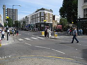
Golborne Road
Encyclopedia

Royal Borough of Kensington and Chelsea
The Royal Borough of Kensington and Chelsea is a central London borough of Royal borough status. After the City of Westminster, it is the wealthiest borough in England....
in London's Notting Hill
Notting Hill
Notting Hill is an area in London, England, close to the north-western corner of Kensington Gardens, in the Royal Borough of Kensington and Chelsea...
. The road runs east from Portobello Road
Portobello Road
Portobello Road is a street in the Notting Hill district of The Royal Borough of Kensington and Chelsea in west London, England. It runs almost the length of Notting Hill from south to north, roughly parallel with Ladbroke Grove. On Saturdays it is home to Portobello Road Market, one of London's...
to Kensal Road.
The nearest Underground
London Underground
The London Underground is a rapid transit system serving a large part of Greater London and some parts of Buckinghamshire, Hertfordshire and Essex in England...
stations are Westbourne Park
Westbourne Park tube station
Westbourne Park is a London Underground station on the Circle and Hammersmith and City lines, between Ladbroke Grove and Royal Oak stations, and in Travelcard Zone 2 in The Royal Borough of Kensington and Chelsea . Although the Metropolitan Railway had been extended to Notting Hill and Hammersmith...
and Ladbroke Grove
Ladbroke Grove tube station
Ladbroke Grove is a London Underground station on the Circle and Hammersmith & City lines, between Latimer Road and Westbourne Park stations, and in Travelcard Zone 2 set in The Royal Borough of Kensington and Chelsea ....
.
Golborne Road is situated just north of and parallel to the Westway
Westway (London)
The Westway is a long elevated dual carriageway section of the A40 route in west London running from Paddington to North Kensington. The road was constructed between 1964 and 1970 to relieve congestion at Shepherd's Bush caused by traffic from Western Avenue struggling to enter central London on...
; it also joins Portobello Road
Portobello Road
Portobello Road is a street in the Notting Hill district of The Royal Borough of Kensington and Chelsea in west London, England. It runs almost the length of Notting Hill from south to north, roughly parallel with Ladbroke Grove. On Saturdays it is home to Portobello Road Market, one of London's...
.
This area of Notting Hill
Notting Hill
Notting Hill is an area in London, England, close to the north-western corner of Kensington Gardens, in the Royal Borough of Kensington and Chelsea...
's northern corner has changed dramatically over its history. The area was part of the Great Forest of Middlesex
Forest of Middlesex
The Forest of Middlesex was an ancient woodland covering much of the county of Middlesex, England that was north of the City of London and now forms the northern part of Greater London. A path was cut through the forest for the creation of Watling Street. At its ancient extent the forest stretched...
; in 1543 the land was seized by Henry VIII
Henry VIII of England
Henry VIII was King of England from 21 April 1509 until his death. He was Lord, and later King, of Ireland, as well as continuing the nominal claim by the English monarchs to the Kingdom of France...
and by the eighteenth century Golborne was farmland.
Golborne Road was named after Dean Golbourne, at one time vicar of St. John's Church in Paddington
Paddington
Paddington is a district within the City of Westminster, in central London, England. Formerly a metropolitan borough, it was integrated with Westminster and Greater London in 1965...
. Until the middle of the nineteenth century it was no more than a country footpath crossing the fields of Portobello Farm, but in 1870 the road was widened, shops were built and the road was extended over the railway.
The Golborne Road area is sometimes known as "Little Morocco
Morocco
Morocco , officially the Kingdom of Morocco , is a country located in North Africa. It has a population of more than 32 million and an area of 710,850 km², and also primarily administers the disputed region of the Western Sahara...
" due to the number of Moroccan restaurants and shops selling Maghreb
Maghreb
The Maghreb is the region of Northwest Africa, west of Egypt. It includes five countries: Morocco, Algeria, Tunisia, Libya, and Mauritania and the disputed territory of Western Sahara...
ian products located along the road.
The road also has renown in the Portuguese community for the two Portuguese Pâtisseries at one end (Oporto and Lisboa).
Golborne Road hosts a street market every day except Sunday, specialising in produce with hot food and bric-a-brac
Bric-a-brac
Bric-à-brac , first used in the Victorian era, refers to collections of curios such as elaborately decorated teacups and small vases, feathers, wax flowers under glass domes, eggshells, statuettes, painted miniatures or photographs, and so on...
at the weekend. The Royal Borough of Kensington and Chelsea
Royal Borough of Kensington and Chelsea
The Royal Borough of Kensington and Chelsea is a central London borough of Royal borough status. After the City of Westminster, it is the wealthiest borough in England....
began a process of consultation on the future of the market and associated amenities in 2005; the consultants' initial report is available here.
External links
- Golborne Life, the community website for the Golborne Road area

