Glenville, West Virginia
Encyclopedia


County seat
A county seat is an administrative center, or seat of government, for a county or civil parish. The term is primarily used in the United States....
of Gilmer County
Gilmer County, West Virginia
As of the census of 2000, there were 7,160 people, 2,768 households, and 1,862 families residing in the county. The population density was 21 people per square mile . There were 3,621 housing units at an average density of 11 per square mile...
, West Virginia
West Virginia
West Virginia is a state in the Appalachian and Southeastern regions of the United States, bordered by Virginia to the southeast, Kentucky to the southwest, Ohio to the northwest, Pennsylvania to the northeast and Maryland to the east...
, United States
United States
The United States of America is a federal constitutional republic comprising fifty states and a federal district...
, along the Little Kanawha River
Little Kanawha River
The Little Kanawha River is a tributary of the Ohio River, 169 mi long, in western West Virginia in the United States. Via the Ohio, it is part of the watershed of the Mississippi River, draining an area of 2,320 mi² on the unglaciated portion of the Allegheny Plateau...
. The population was 1,544 at the 2000 census. It is the home of Glenville State College
Glenville State College
Glenville State College is a public four-year college located in Glenville, a town in the rural north-central part of the U.S. state of West Virginia.-History:...
.
History
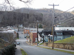
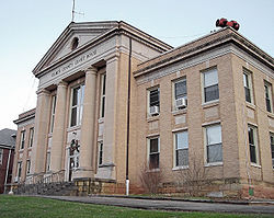
In the late 1700s and early 1800s, white pioneers began settling in the area they called ‘‘the Ford’’ because it was a place where travelers could cross the river. Later, the community was named Glenville because of its location in a glen. The first grist mill in Gilmer County was constructed there in 1812. The first courthouse was completed in 1850, the second in 1872, and the current courthouse in 1923. Glenville was incorporated in 1856.Before the 1930s, the Little Kanawha River
Little Kanawha River
The Little Kanawha River is a tributary of the Ohio River, 169 mi long, in western West Virginia in the United States. Via the Ohio, it is part of the watershed of the Mississippi River, draining an area of 2,320 mi² on the unglaciated portion of the Allegheny Plateau...
’s commercial traffic dominated the town’s economy. Road construction contributed to the demise of riverboating by the late 1930s. The natural gas and oil industry rose to prominence after oil was struck in 1875 at nearby Letter Gap. Glenville is now the headquarters of several oil and gas firms. The 1985 flood devastated the downtown, leading many businesses to move to the higher Hays City neighborhood at the main highway intersection.
The Little Kanawha Valley Bank
Little Kanawha Valley Bank
Little Kanawha Valley Bank is a historic bank building located at Glenville, Gilmer County, West Virginia. It was built in 1901, and is a small one story commercial building with Classical Revival-style details. It is a rectangular frame building covered in pressed sheet metal...
was incorporated in 1901. Its small frame building, covered in pressed metal, is now on the National Register of Historic Places
National Register of Historic Places
The National Register of Historic Places is the United States government's official list of districts, sites, buildings, structures, and objects deemed worthy of preservation...
. By 1906, the First National Bank of Glenville and the Glenville Banking and Trust Company had also been created. Glenville is now served by United Bank and a branch of Calhoun Banks of Grantsville.
Early Methodist circuit riders and Baptist missionaries brought religion to Glenville early in the 19th century. The Presbyterian Church was organized in 1847; the First Baptist Church, 1850; and Trinity United Methodist Church, 1896. Several other churches also serve the area today. Glenville has a golf club and recreation center, among several other facilities built at the old county poor farm
Gilmer County Poor Farm Infirmary
Gilmer County Poor Farm Infirmary is a historic poor farm infirmary building located near Glenville, Gilmer County, West Virginia. It was built in 1907, and is a two story, three bay, center entrance frame building with a cross-hip pitched roof and Colonial Revival-style details...
.
In 1885, the Glenville Crescent first published Ellen King’s poem, ‘‘The West Virginia Hills,’’ which later became the official state song. While this newspaper didn’t survive, the Glenville Pathfinder (1892) and the Glenville Democrat (1904) have.
Geography
Glenville is located at 38°56′7"N 80°50′14"W (38.935405, -80.837114).According to the United States Census Bureau
United States Census Bureau
The United States Census Bureau is the government agency that is responsible for the United States Census. It also gathers other national demographic and economic data...
, the town has a total area of 1.1 square miles (2.8 km²), all land.
Demographics
As of the censusCensus
A census is the procedure of systematically acquiring and recording information about the members of a given population. It is a regularly occurring and official count of a particular population. The term is used mostly in connection with national population and housing censuses; other common...
of 2000, there were 1,544 people, 527 households, and 235 families residing in the town. The population density
Population density
Population density is a measurement of population per unit area or unit volume. It is frequently applied to living organisms, and particularly to humans...
was 1,428.7 inhabitants per square mile (552.0/km²). There were 654 housing units at an average density of 605.2 per square mile (233.8/km²). The racial makeup of the town was 92.75% White, 3.17% African American, 0.13% Native American, 2.40% Asian, 0.26% from other races
Race (United States Census)
Race and ethnicity in the United States Census, as defined by the Federal Office of Management and Budget and the United States Census Bureau, are self-identification data items in which residents choose the race or races with which they most closely identify, and indicate whether or not they are...
, and 1.30% from two or more races. Hispanic or Latino of any race were 0.58% of the population.
There were 527 households out of which 17.6% had children under the age of 18 living with them, 31.1% were married couples
Marriage
Marriage is a social union or legal contract between people that creates kinship. It is an institution in which interpersonal relationships, usually intimate and sexual, are acknowledged in a variety of ways, depending on the culture or subculture in which it is found...
living together, 9.1% had a female householder with no husband present, and 55.4% were non-families. 36.8% of all households were made up of individuals and 12.9% had someone living alone who was 65 years of age or older. The average household size was 2.10 and the average family size was 2.82.
In the town the population was spread out with 11.9% under the age of 18, 43.1% from 18 to 24, 16.1% from 25 to 44, 14.5% from 45 to 64, and 14.4% who were 65 years of age or older. The median age was 23 years. For every 100 females there were 101.0 males. For every 100 females age 18 and over, there were 105.1 males.
The median income for a household in the town was $20,243, and the median income for a family was $33,036. Males had a median income of $24,583 versus $18,375 for females. The per capita income
Per capita income
Per capita income or income per person is a measure of mean income within an economic aggregate, such as a country or city. It is calculated by taking a measure of all sources of income in the aggregate and dividing it by the total population...
for the town was $10,304. About 21.5% of families and 38.5% of the population were below the poverty line, including 44.9% of those under age 18 and 13.8% of those age 65 or over.
Education
As early as 1833, a high school was established in the Methodist Episcopal Church. After moving to the courthouse in 1850 and into a house in 1884, the school got its own building in 1913. Glenville High School was replaced by the consolidated Gilmer County High School in 1968. What is now Glenville State College was founded in 1872.Culture
In 1950, folklorist Patrick Gainer established the West Virginia State Folk Festival at the college. It has been held each June since then, making it one of the two oldest such events in the United States.External links
- Glenville Democrat and Pathfinder (local newspaper)
- West Virginia State Folk Festival
- Self Suds Laundromat (Super Clean!)

