

Glasgow Inner Ring Road
Encyclopedia
Central business district
A central business district is the commercial and often geographic heart of a city. In North America this part of a city is commonly referred to as "downtown" or "city center"...
of Glasgow
Glasgow
Glasgow is the largest city in Scotland and third most populous in the United Kingdom. The city is situated on the River Clyde in the country's west central lowlands...
, Scotland. Construction of the roads began in 1965, and half of its circumference was completed by 1972, but no subsequent construction was made and the remaining plans were formally abandoned in 1980. After 30 years, souther section of the proposals have become part of the new M74,
The Bruce Report
The Bruce ReportBruce Report
The Bruce Report is the name commonly given to two urban redevelopment reports of the Glasgow Corporation ....
, a wide-ranging investigation into the post-war regeneration of the city, proposed (in addition to other road plans and a redistribution of rail termini) a system of motorways into and around central Glasgow. At least three new arterial motorways, the Monklands, Renfrew and Maryhill Motorways, would be constructed in towards the city centre, terminating on a new ring road. The ring would take the shape of a "box" around the centre, with four straight flanks and an interchange
Interchange (road)
In the field of road transport, an interchange is a road junction that typically uses grade separation, and one or more ramps, to permit traffic on at least one highway to pass through the junction without directly crossing any other traffic stream. It differs from a standard intersection, at which...
at each corner for a connection to the perpendicular section of the ring and to the new arterials. The plans were drawn up in the years immediately following World War II
World War II
World War II, or the Second World War , was a global conflict lasting from 1939 to 1945, involving most of the world's nations—including all of the great powers—eventually forming two opposing military alliances: the Allies and the Axis...
, and the initial contracts were handed out after consultation between the Glasgow City Corporation and its traffic consultants Scott Wilson Kilpatrick & Co., to build the northern and western flanks of the ring in four stages; Townhead, Woodside, Charing Cross and Kingston Bridge
Kingston Bridge, Glasgow
The Kingston Bridge is a balanced cantilever dual-span ten lane road bridge made of triple-cell segmented prestressed concrete box girders crossing the River Clyde in Glasgow, Scotland. The largest urban bridge in the United Kingdom, it carries the M8 motorway through the city centre...
. Construction of the flanks began in 1965.
North and West Flanks
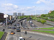
The North Flank of the ring (the Townhead and Woodside sections) runs between an interchange at St George's Cross in WoodsideWoodside, Glasgow
Woodside is a district in the Scottish city of Glasgow. It is situated north of the River Clyde, between the River Kelvin and the Forth and Clyde canal....
and an interchange at Townhead
Townhead
-Location:Townhead has no fixed boundaries. In ancient times it was the undeveloped area north of the cathedral and town. If we use this description then it is bordered to the west by the area of Cowcaddens, to the north by Sighthill and the east by Royston and south by Merchant City...
, passing through the districts of Garnethill
Garnethill
Garnethill is a predominantly residential area of the city of Glasgow, Scotland.-Geography:Located in the city centre, the area borders Cowcaddens to its north, Sauchiehall Street to its south, Cambridge Street to its east and the M8 motorway to its west....
and Cowcaddens
Cowcaddens
Cowcaddens is an area of the city of Glasgow, Scotland. It is virtually in the city centre and is bordered by the areas of Garnethill to the south and Townhead to the east....
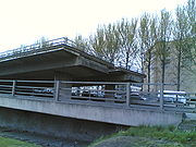
. The entire section was elevated over the surrounding land on a concrete viaduct
Viaduct
A viaduct is a bridge composed of several small spans. The term viaduct is derived from the Latin via for road and ducere to lead something. However, the Ancient Romans did not use that term per se; it is a modern derivation from an analogy with aqueduct. Like the Roman aqueducts, many early...
. The first contract was awarded for the Townhead section and it was the first section completed, opening in April 1968. The Woodlands section completed the North Flank in May 1971.
The West Flank (the Charing Cross and Kingston Bridge sections) was planned to run from the St George's Cross interchange, sweeping beneath Charing Cross
Charing Cross, Glasgow
Charing Cross is a major road junction in the Scottish city of Glasgow. It is situated north of the River Clyde on Sauchiehall Street, at a major interchange of the M8 motorway. Formerly the gateway from the shopping area of Sauchiehall Street to the more prosperous Woodlands area, its...
and through Anderston
Anderston
Anderston is a district in the Scottish city of Glasgow. It is on the north bank of the River Clyde and extends to the western edge of the city centre...
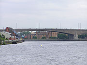
before rising to cross the River Clyde
River Clyde
The River Clyde is a major river in Scotland. It is the ninth longest river in the United Kingdom, and the third longest in Scotland. Flowing through the major city of Glasgow, it was an important river for shipbuilding and trade in the British Empire....
and run to an interchange at Tradeston
Tradeston
Tradeston is a district in the Scottish city of Glasgow adjacent to the city centre on the south bank of the River Clyde.-Geography:Tradeston is bounded by the River Clyde to the north, the Glasgow to Paisley railway line on the east and south and the Kingston Bridge and M8 motorway to the west...
. The river crossing, whose feasibility had been considered even before the proposal of the ring road, was completed in June 1970 and opened by Queen Elizabeth, the Queen Mother
Elizabeth Bowes-Lyon
Elizabeth Angela Marguerite Bowes-Lyon was the queen consort of King George VI from 1936 until her husband's death in 1952, after which she was known as Queen Elizabeth The Queen Mother, to avoid confusion with her daughter, Queen Elizabeth II...
. The Charing Cross section completing the link to St George's Cross was made in February 1972, marking the end of the originally contracted work. The North and West Flanks form 2.5 miles of motorway, built at a cost of around £
Pound sterling
The pound sterling , commonly called the pound, is the official currency of the United Kingdom, its Crown Dependencies and the British Overseas Territories of South Georgia and the South Sandwich Islands, British Antarctic Territory and Tristan da Cunha. It is subdivided into 100 pence...
27 million.
In 1993 the conservation organisation DoCoMoMo listed the completed sections of the inner ring road as one of the sixty key Scottish monuments
DoCoMoMo Key Scottish Monuments
DoCoMoMo Key Scottish Monuments is a list of 60 notable post-war buildings in Scotland, compiled in 1993 by the international architectural conservation organisation DoCoMoMo....
of the post-war
Post-war
A post-war period or postwar period is the interval immediately following the ending of a war and enduring as long as war does not resume. A post-war period can become an interwar period or interbellum when a war between the same parties resumes at a later date...
period.
Junctions with existing and proposed roads
At the Townhead (north-east) interchange, a complex grade separatedGrade separation
Grade separation is the method of aligning a junction of two or more transport axes at different heights so that they will not disrupt the traffic flow on other transit routes when they cross each other. The composition of such transport axes does not have to be uniform; it can consist of a...
junction
Junction (road)
A road junction is a location where vehicular traffic going in different directions can proceed in a controlled manner designed to minimize accidents. In some cases, vehicles can change between different routes or directions of travel.-Origins:...
was laid out to connect the North Flank of the ring to three roads proposed or under construction (the East Flank, the A803 Springburn Expressway, and to the Monklands Motorway to carry traffic out of the city to the east and on to Edinburgh
Edinburgh
Edinburgh is the capital city of Scotland, the second largest city in Scotland, and the eighth most populous in the United Kingdom. The City of Edinburgh Council governs one of Scotland's 32 local government council areas. The council area includes urban Edinburgh and a rural area...
) and to the existing A8 road towards Dennistoun
Dennistoun
Dennistoun is a district of the city of Glasgow, Scotland. It is situated north of the River Clyde in the east end of the city. It is made up of a number of smaller districts - Milnbank to the north, 'The Drives' in the centre of the area and Bellgrove below Duke Street to the south. In a 2004...
and Glasgow Cross
Glasgow Cross
Glasgow Cross is a major junction in the city centre of Glasgow, which has, at its centre, five streets running from it: the High Street, Gallowgate, London Road, the Saltmarket and the Trongate ....
. The entire project entailed the construction of ten bridges and six pedestrian subways with over 5,000 feet of interconnecting passages.
The south-western interchange at Tradeston was built to incorporate connections to the South Flank and to the Renfrew Motorway to carry traffic out of the city westwards to Greenock
Greenock
Greenock is a town and administrative centre in the Inverclyde council area in United Kingdom, and a former burgh within the historic county of Renfrewshire, located in the west central Lowlands of Scotland...
and Glasgow Airport
Glasgow Airport
Glasgow Airport may refer to:*Glasgow International Airport, in Renfrewshire, the primary airport serving Glasgow, Scotland, United Kingdom.*Glasgow Airport , also known as Wokal Field, in Glasgow, Montana, United States.It may also refer to:...
. Additional links were provided for surface roads including those to Kinning Park
Kinning Park
Kinning Park is a southern suburb of Glasgow, Scotland. In 1897 it had a population of 14326.-Political history:Originally a separate police burgh founded in 1871, it became part of Glasgow in 1905. It was the smallest such burgh in Scotland at just...
and the Gorbals
Gorbals
The Gorbals is an area on the south bank of the River Clyde in the city of Glasgow, Scotland. By the late 19th century, it had become over-populated and adversely affected by local industrialisation. Many people lived here because their jobs provided this home and they could not afford their own...
.
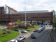
Further junctions were provided with existing roads in and out of the centre at Cowcaddens, to the Great Western Road (A82), to streets in the upmarket business district, and to the new A814 Clydeside Expressway.
East and South Flanks
Plans for the South and East Flanks were never finalised, but it is known that the South Flank would have interchanged with the A77A77 road
The A77 road is a major road in Scotland. It runs in a southwesternly direction from the city of Glasgow, past the towns of Giffnock, Newton Mearns, Kilmarnock, Prestwick, Ayr, Maybole, Girvan and Stranraer to the town of Portpatrick on the Irish Sea...
at Eglinton Street. Both flanks would have been elevated and met in the Gorbals or Laurieston
Laurieston, Glasgow
Laurieston is a district in the Gorbals area of the Scottish city of Glasgow. It is situated south of the River Clyde.It derives its name from James Laurie who, along with his brother, developed a large part of the district in the early 19th century....
.
Abandonment
A number of visible loose ends were left behind because of the abandonment. Amongst the most infamous examples are the access to the unbuilt south section at Tradeston which was left as a "ski-jump" (the road abruptly terminates in mid-air), the tangle of slip-roads at Tradeston, and the "Bridge to Nowhere
M8 Bridge to Nowhere
The Bridges to Nowhere is a colloquial nickname given to two unfinished structures 600 metres apart over the M8 motorway in Glasgow. Both attracted a degree of notoriety as examples of the incompleteness of the Glasgow Inner Ring Road...
", one of a number of unfinished pedestrian overpasses, which stood empty for many years and is now the support for an office block.
The M8 is consistently jammed at rush hour, with the Kingston Bridge having to cope with vast amounts of traffic that would have been redirected to other roads had the ring been completed; this traffic load has necessitated extensive roadworks on the bridge amplifying congestion. The motorway is derided in popular culture, with Glasgow-based pop band Deacon Blue
Deacon Blue
Deacon Blue are a Scottish pop band formed in Glasgow during 1985. Their name was taken from the title of the Steely Dan song "Deacon Blues". The band consists of vocalist Ricky Ross and Lorraine McIntosh, keyboard player James Prime and drummer Dougie Vipond....
's album Raintown
Raintown
Raintown is the debut album of Scottish pop band Deacon Blue. The album, written largely by lead singer Ricky Ross, was released in the United Kingdom on May 1, 1987...
largely forming an attack on the inner-city atmosphere of the road, and including a picture of it cutting through the city on the rear cover.
Resurrection
The continued [traffic congestion] in central Glasgow have led to proposals for the completion of the missing two sides of the ring, albeit in a different form. The Scottish ExecutiveScottish Executive
The Scottish Government is the executive arm of the devolved government of Scotland. It was established in 1999 as the Scottish Executive, from the extant Scottish Office, and the term Scottish Executive remains its legal name under the Scotland Act 1998...
hopes to alleviate congestion on the Kingston Bridge and in the city centre by providing an East and South Flank in different forms.
Southern section
Plans published by the Scottish Executive in 2003 propose the extension of the M74 motorwayM74 motorway
The A74 and M74 motorways form a major motorway in Scotland. Following an extension opened on 28 June 2011, it connects the M8 motorway west of Glasgow to the English border at Gretna, creating an alternative route for traffic moving from the south to the west of the city...
from its current terminus of in the south-east of the city towards the Kingston Bridge. This motorway is planned to pass through Polmadie and the Gorbals - on elevated sections like the original preliminary plans for the South Flank - and to meet the existing motorway at Tradeston, albeit a few hundred metres south of the existing interchange leaving the 'ski-jump' untouched. The plans went to public inquiry
Public inquiry
A Tribunal of Inquiry is an official review of events or actions ordered by a government body in Common Law countries such as the United Kingdom, Ireland or Canada. Such a public inquiry differs from a Royal Commission in that a public inquiry accepts evidence and conducts its hearings in a more...
in 2004, and although it rejected the plans, then-Transport Minister Nicol Stephen
Nicol Stephen
Nicol Ross Stephen, Baron Stephen of Lower Deeside in the City of Aberdeen is a Scottish Liberal Democrat politician. He was the Member of the Scottish Parliament for Aberdeen South, and was leader of the Scottish Liberal Democrats from 2005 to 2008...
approved the plans. The project was stalled by legal challenges which collapsed in June 2006, paving the way for the road to be finally constructed.. The road opened to traffic in June 2011.
Eastern section
The East End Regeneration Route, originally a proposal to supplement the East Flank, has been championed by Glasgow City Council as the preferred solution for completion of the ring. The plans are for a road linking the M74 extension to the M8 at the Provan Gas WorksProvan Gas Works
Provan Gas Works is an industrial gas holding plant in the city of Glasgow, Scotland. The plant is in the Provanmill area of the city, and was built by Glasgow Corporation between 1900 and 1904...
, east of the interchange at Townhead. It is extremely unlikely that this section would be built to motorway standard; instead the road would form an urban corridor, part of which exists as a road bypassing Parkhead
Parkhead
Parkhead is a district in the East End of Glasgow. Its name comes from a small weaving hamlet at the meeting place of the Great Eastern Road and Westmuir Street. Duke Street and Springfield Road also meet there, to form a turreted Edwardian five-way junction at Parkhead Cross...
built in 1988 as part of The Forge shopping centre. The road is proposed to run through Hogarth Park (where a former railway embankment is now used as public open space), Haghill
Haghill
Haghill is a district in the Scottish city of Glasgow. It is situated in the east end of Glasgow, north of the River Clyde. The housing includes tenements, former council houses and several more recently constructed homes. It is bordered by Riddrie to the north, Carntyne to the east and Dennistoun...
and Carntyne
Carntyne
Carntyne is a district in the Scottish city of Glasgow. It is situated north of the River Clyde, and to the east end of the city...
, beneath the A8 Edinburgh Road, continuing along a disused railway alignment to Provan. Construction work began in early 2010, and is projected to be complete by the end of 2011.
Other initiatives
In late 2005, after years of planning, Glasgow City Council began work on a new road bridge, the Clyde ArcClyde Arc
The Clyde Arc , is a road bridge spanning the River Clyde in Glasgow, in west central Scotland, connecting Finnieston, near the Clyde Auditorium and SECC with Pacific Quay and Glasgow Science Centre in Govan. A prominent feature of the bridge is its innovative curved design and the way that it...
, (commonly known locally as the "Squinty Bridge") over the Clyde alongside the Kingston which connects Finnieston
Finnieston
Finnieston is an area of Glasgow, Scotland, situated on the North bank of the River Clyde and between the city's West End and the city centre. It is home to the SECC, where many musical concerts and important conferences are held...
on the north bank to Kinning Park on the south. The first new road crossing of the Clyde in Glasgow since the Kingston Bridge in 1970, the new structure is intended to divert local traffic away from using the M8 to cross the river. It opened in September 2006. On the night of 14 January 2008, one of the support cables snapped, subsequently closing the Clyde Arc for all traffic.