
Gilford, New Hampshire
Encyclopedia
Gilford is a town
in Belknap County
, New Hampshire
, United States
. The population was 7,126 at the 2010 census. Situated on Lake Winnipesaukee
, Gilford is home to Governors Island
, Ellacoya State Beach
, Belknap Mountain
State Forest, Gunstock Mountain Ski Resort
, and Meadowbrook U.S. Cellular Pavilion
, a seasonal outdoor concert facility.
, the town was first called Gunstock Parish. In 1812, Captain Lemuel B. Mason, who had fought in the 1781 Battle of Guilford Court House
in North Carolina
during the Revolutionary War
and subsequently retired to Gunstock Parish, successfully proposed incorporation of a new town to be named Guilford after that battle. The name would later be contracted by clerical error. The original parish name is used by Gunstock Mountain
and the ski resort
located on it.
, the town has a total area of 53.8 square miles (139.3 km²), of which 39 sq mi (101 km²) is land and 14.9 sq mi (38.6 km²) is water, comprising 27.59% of the town. Belknap Mountain
, elevation 2384 feet (726.6 m) above sea level
and the highest point in Gilford, is in the south. Much of the town is drained by the Gunstock River
, a tributary of Lake Winnipesaukee
. Gilford lies fully within the Merrimack River
watershed
.
The town is served by state routes 11
, 11A and 11B.
of 2000, there were 6,803 people, 2,766 households, and 2,019 families residing in the town. The population density
was 174.6 people per square mile (67.4/km²). There were 4,312 housing units at an average density of 110.6 per square mile (42.7/km²). The racial makeup of the town was 98.32% White, 0.19% African American, 0.15% Native American, 0.51% Asian, 0.07% from other races
, and 0.75% from two or more races. Hispanic or Latino of any race were 0.57% of the population.
There were 2,766 households out of which 30.8% had children under the age of 18 living with them, 61.9% were married couples
living together, 8.1% had a female householder with no husband present, and 27.0% were non-families. 21.7% of all households were made up of individuals and 9.0% had someone living alone who was 65 years of age or older. The average household size was 2.46 and the average family size was 2.85.
In the town the population was spread out with 23.7% under the age of 18, 4.4% from 18 to 24, 25.4% from 25 to 44, 29.6% from 45 to 64, and 16.8% who were 65 years of age or older. The median age was 43 years. For every 100 females there were 92.0 males. For every 100 females age 18 and over, there were 89.8 males.
The median income for a household in the town was $48,658, and the median income for a family was $56,554. Males had a median income of $38,839 versus $27,325 for females. The per capita income
for the town was $32,667. About 2.2% of families and 3.3% of the population were below the poverty line, including 1.2% of those under age 18 and 2.7% of those age 65 or over.
New England town
The New England town is the basic unit of local government in each of the six New England states. Without a direct counterpart in most other U.S. states, New England towns are conceptually similar to civil townships in other states, but are incorporated, possessing powers like cities in other...
in Belknap County
Belknap County, New Hampshire
-Demographics:As of the census of 2000, there were 56,325 people, 22,459 households, and 15,496 families residing in the county. The population density was 140 people per square mile . There were 32,121 housing units at an average density of 80 per square mile...
, New Hampshire
New Hampshire
New Hampshire is a state in the New England region of the northeastern United States of America. The state was named after the southern English county of Hampshire. It is bordered by Massachusetts to the south, Vermont to the west, Maine and the Atlantic Ocean to the east, and the Canadian...
, United States
United States
The United States of America is a federal constitutional republic comprising fifty states and a federal district...
. The population was 7,126 at the 2010 census. Situated on Lake Winnipesaukee
Lake Winnipesaukee
Lake Winnipesaukee is the largest lake in the U.S. state of New Hampshire. It is approximately long and from wide , covering — when Paugus Bay is included—with a maximum depth of ....
, Gilford is home to Governors Island
Governors Island (Lake Winnipesaukee)
Governors Island is one of five bridged islands on Lake Winnipesaukee and is part of the town of Gilford, New Hampshire. The island supports high end housing and cultural activities.-See also:...
, Ellacoya State Beach
Ellacoya State Park
Ellacoya State Park is a state park in Gilford, New Hampshire. Located on the southwest shore of Lake Winnipesaukee, the park has 600 feet of beachfront.-External links:*...
, Belknap Mountain
Belknap Mountain
-Belknap Mountain is a mountain located in Belknap County, New Hampshire, south of Lake Winnipesaukee. Like the county, the mountain and the associated Belknap Mountains are named after Jeremy Belknap , a renowned preacher, historian, and author of The History of New Hampshire.The peak of Belknap Mtn...
State Forest, Gunstock Mountain Ski Resort
Gunstock Mountain Resort
Gunstock Mountain Resort is a sports complex located on Gunstock Mountain in Gilford, New Hampshire, and is owned by Belknap County. Activities include alpine and cross-country skiing, snow tubing, ski jumping, snowshoeing, hiking, swimming, and skateboarding.-History:The original Gunstock...
, and Meadowbrook U.S. Cellular Pavilion
Meadowbrook U.S. Cellular Pavilion
Meadowbrook U.S. Cellular Pavilion is an outdoor amphitheater located near Lake Winnipesaukee in Gilford, New Hampshire, USA.-History:The land was originally owned by the Miller family, who used the property for summer vacations, weekend excursions, and general family entertainment. By the early...
, a seasonal outdoor concert facility.
History
Settled in 1778 and originally a part of GilmantonGilmanton, New Hampshire
Gilmanton is a town in Belknap County, New Hampshire, United States. The population was 3,777 at the 2010 census. Gilmanton includes the villages of Gilmanton Corner and Gilmanton Ironworks...
, the town was first called Gunstock Parish. In 1812, Captain Lemuel B. Mason, who had fought in the 1781 Battle of Guilford Court House
Battle of Guilford Court House
The Battle of Guilford Court House was a battle fought on March 15, 1781 in Greensboro, the county seat of Guilford County, North Carolina, during the American Revolutionary War...
in North Carolina
North Carolina
North Carolina is a state located in the southeastern United States. The state borders South Carolina and Georgia to the south, Tennessee to the west and Virginia to the north. North Carolina contains 100 counties. Its capital is Raleigh, and its largest city is Charlotte...
during the Revolutionary War
American Revolutionary War
The American Revolutionary War , the American War of Independence, or simply the Revolutionary War, began as a war between the Kingdom of Great Britain and thirteen British colonies in North America, and ended in a global war between several European great powers.The war was the result of the...
and subsequently retired to Gunstock Parish, successfully proposed incorporation of a new town to be named Guilford after that battle. The name would later be contracted by clerical error. The original parish name is used by Gunstock Mountain
Gunstock Mountain
Gunstock Mountain, elevation , is the second highest peak in the Belknap Range of central New Hampshire. It is located north of Belknap Mountain, the highest point in the range. It is also the home to Gunstock Mountain Resort ski area...
and the ski resort
Gunstock Mountain Resort
Gunstock Mountain Resort is a sports complex located on Gunstock Mountain in Gilford, New Hampshire, and is owned by Belknap County. Activities include alpine and cross-country skiing, snow tubing, ski jumping, snowshoeing, hiking, swimming, and skateboarding.-History:The original Gunstock...
located on it.
Geography
According to the United States Census BureauUnited States Census Bureau
The United States Census Bureau is the government agency that is responsible for the United States Census. It also gathers other national demographic and economic data...
, the town has a total area of 53.8 square miles (139.3 km²), of which 39 sq mi (101 km²) is land and 14.9 sq mi (38.6 km²) is water, comprising 27.59% of the town. Belknap Mountain
Belknap Mountain
-Belknap Mountain is a mountain located in Belknap County, New Hampshire, south of Lake Winnipesaukee. Like the county, the mountain and the associated Belknap Mountains are named after Jeremy Belknap , a renowned preacher, historian, and author of The History of New Hampshire.The peak of Belknap Mtn...
, elevation 2384 feet (726.6 m) above sea level
Sea level
Mean sea level is a measure of the average height of the ocean's surface ; used as a standard in reckoning land elevation...
and the highest point in Gilford, is in the south. Much of the town is drained by the Gunstock River
Gunstock River
The Gunstock River is a river in the Lakes Region of central New Hampshire in the United States. It is a tributary of Lake Winnipesaukee, part of the Merrimack River watershed.The Gunstock River is entirely within the town of Gilford, New Hampshire...
, a tributary of Lake Winnipesaukee
Lake Winnipesaukee
Lake Winnipesaukee is the largest lake in the U.S. state of New Hampshire. It is approximately long and from wide , covering — when Paugus Bay is included—with a maximum depth of ....
. Gilford lies fully within the Merrimack River
Merrimack River
The Merrimack River is a river in the northeastern United States. It rises at the confluence of the Pemigewasset and Winnipesaukee rivers in Franklin, New Hampshire, flows southward into Massachusetts, and then flows northeast until it empties into the Atlantic Ocean at Newburyport...
watershed
Drainage basin
A drainage basin is an extent or an area of land where surface water from rain and melting snow or ice converges to a single point, usually the exit of the basin, where the waters join another waterbody, such as a river, lake, reservoir, estuary, wetland, sea, or ocean...
.
The town is served by state routes 11
New Hampshire Route 11
New Hampshire Route 11 is a long east–west state highway in New Hampshire, running westward along the southern shore of Lake Winnipesaukee. Its eastern terminus is at the Maine state line in the city of Rochester, where it continues north as Maine State Route 11. U.S. Route 202, which runs...
, 11A and 11B.
Demographics
As of the censusCensus
A census is the procedure of systematically acquiring and recording information about the members of a given population. It is a regularly occurring and official count of a particular population. The term is used mostly in connection with national population and housing censuses; other common...
of 2000, there were 6,803 people, 2,766 households, and 2,019 families residing in the town. The population density
Population density
Population density is a measurement of population per unit area or unit volume. It is frequently applied to living organisms, and particularly to humans...
was 174.6 people per square mile (67.4/km²). There were 4,312 housing units at an average density of 110.6 per square mile (42.7/km²). The racial makeup of the town was 98.32% White, 0.19% African American, 0.15% Native American, 0.51% Asian, 0.07% from other races
Race (United States Census)
Race and ethnicity in the United States Census, as defined by the Federal Office of Management and Budget and the United States Census Bureau, are self-identification data items in which residents choose the race or races with which they most closely identify, and indicate whether or not they are...
, and 0.75% from two or more races. Hispanic or Latino of any race were 0.57% of the population.
There were 2,766 households out of which 30.8% had children under the age of 18 living with them, 61.9% were married couples
Marriage
Marriage is a social union or legal contract between people that creates kinship. It is an institution in which interpersonal relationships, usually intimate and sexual, are acknowledged in a variety of ways, depending on the culture or subculture in which it is found...
living together, 8.1% had a female householder with no husband present, and 27.0% were non-families. 21.7% of all households were made up of individuals and 9.0% had someone living alone who was 65 years of age or older. The average household size was 2.46 and the average family size was 2.85.
In the town the population was spread out with 23.7% under the age of 18, 4.4% from 18 to 24, 25.4% from 25 to 44, 29.6% from 45 to 64, and 16.8% who were 65 years of age or older. The median age was 43 years. For every 100 females there were 92.0 males. For every 100 females age 18 and over, there were 89.8 males.
The median income for a household in the town was $48,658, and the median income for a family was $56,554. Males had a median income of $38,839 versus $27,325 for females. The per capita income
Per capita income
Per capita income or income per person is a measure of mean income within an economic aggregate, such as a country or city. It is calculated by taking a measure of all sources of income in the aggregate and dividing it by the total population...
for the town was $32,667. About 2.2% of families and 3.3% of the population were below the poverty line, including 1.2% of those under age 18 and 2.7% of those age 65 or over.
Sites of interest
- John J. Morrill General Store (1857)
- Benjamin Rowe House (c. 1838)
- Union Meetinghouse (1834)
- Gunstock Mountain ResortGunstock Mountain ResortGunstock Mountain Resort is a sports complex located on Gunstock Mountain in Gilford, New Hampshire, and is owned by Belknap County. Activities include alpine and cross-country skiing, snow tubing, ski jumping, snowshoeing, hiking, swimming, and skateboarding.-History:The original Gunstock...
Notable inhabitants
- Stilson HutchinsStilson HutchinsStilson Hutchins was an American newspaper reporter and publisher, best known as founder of the Washington Post.Hutchins was born in Whitefield, Coos County, New Hampshire, on 14 November 1838, the son of Stilson Eastman and Clara Eaton Hutchins...
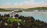
, newspaper reporter and publisher - Benjamin Ames Kimball, railroad president and builder of Kimball Castle (1897)
- Penny PitouPenny PitouPenelope Theresa 'Penny' Pitou is a former United States Olympic alpine skier, who in 1960 became the first American skier to win a medal in the Olympic downhill event. In 2001, Pitou was inducted into the New England Women's Sports Hall of Fame.Penny Pitou moved with her family from New York to...
, first US woman to win an Olympic medal in downhill skiing - Chris Sheridan, writer and television producer