

Gibraltar Arc
Encyclopedia
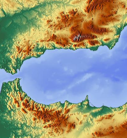
Alboran Sea
|300px|thumb|]]The Alboran Sea is the westernmost portion of the Mediterranean Sea, lying between Spain on the north and Morocco and Algeria on the south...
, between the Iberian Peninsula
Iberian Peninsula
The Iberian Peninsula , sometimes called Iberia, is located in the extreme southwest of Europe and includes the modern-day sovereign states of Spain, Portugal and Andorra, as well as the British Overseas Territory of Gibraltar...
and Africa
Africa
Africa is the world's second largest and second most populous continent, after Asia. At about 30.2 million km² including adjacent islands, it covers 6% of the Earth's total surface area and 20.4% of the total land area...
. It consists of the Betic Cordillera (south Spain), and the Rif
Rif
The Rif or Riff is a mainly mountainous region of northern Morocco, with some fertile plains, stretching from Cape Spartel and Tangier in the west to Ras Kebdana and the Melwiyya River in the east, and from the Mediterranean Sea in the north to the river of Wergha in the south.It is part of the...
(North Morocco).
Maximum altitudes of the region are reached at the Mulhacén
Mulhacén
Mulhacén is the highest mountain in continental Spain and in the Iberian Peninsula. It is part of the Sierra Nevada range in the Cordillera Penibética...
peak (3482 m) at the Cordillera Betica. Precipitation is collected mainly by the Guadalquivir
Guadalquivir
The Guadalquivir is the fifth longest river in the Iberian peninsula and the second longest river to be its whole length in Spain. The Guadalquivir is 657 kilometers long and drains an area of about 58,000 square kilometers...
(Betics) and Sebou
Sebou River
Sebou is a river in northern Morocco. The river is 458 kilometres long and has an average water flow of 137 m3/s, which makes it the largest North African river by volume. The source is in the Middle Atlas mountains. It passes near the city of Fes and discharges to the Atlantic Ocean in Mehdia...
(Rif) rivers, which have delivered most sedimentary infill of the homonym sedimentary foreland basin
Foreland basin
A foreland basin is a depression that develops adjacent and parallel to a mountain belt. Foreland basins form because the immense mass created by crustal thickening associated with the evolution of a mountain belt causes the lithosphere to bend, by a process known as lithospheric flexure...
s.
The geology of this orogen undergoes simultaneous extension coeval to the regional convergence between Iberia and Africa during the Tertiary
Tertiary
The Tertiary is a deprecated term for a geologic period 65 million to 2.6 million years ago. The Tertiary covered the time span between the superseded Secondary period and the Quaternary...
, which has not yet been satisfactorily interpreted.
See also
- Messinian Salinity CrisisMessinian salinity crisisThe Messinian Salinity Crisis, also referred to as the Messinian Event, and in its latest stage as the Lago Mare event, was a geological event during which the Mediterranean Sea went into a cycle of partly or nearly complete desiccation throughout the latter part of the Messinian age of the Miocene...