
Georgia State Route 242
Encyclopedia
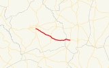
State Route 242 is a west–east state route located in the central part of the U.S. state
of Georgia
. From the route's western terminus at the intersection of State Route 24
and State Route 88, the route travels east, cosigned
with State Route 24 east to Sandersville
. In Sandersville, State Route 242 departs State Route 24, and becomes cosigned with State Route 15 for a short distance in a southerly direction, before departing and continuing east. State Route 242 intersects State Route 231 south of Davisboro
, before continuing east to Bartow
, where it meets its eastern terminus at U.S. Route 221
/U.S. Route 319
/State Route 78/State Route 171.
 Georgia State Route 242 Spur, known locally as Saffold Road, is a short spur from the State Route 242 mainline west of Sandersville.
U.S. state
A U.S. state is any one of the 50 federated states of the United States of America that share sovereignty with the federal government. Because of this shared sovereignty, an American is a citizen both of the federal entity and of his or her state of domicile. Four states use the official title of...
of Georgia
Georgia (U.S. state)
Georgia is a state located in the southeastern United States. It was established in 1732, the last of the original Thirteen Colonies. The state is named after King George II of Great Britain. Georgia was the fourth state to ratify the United States Constitution, on January 2, 1788...
. From the route's western terminus at the intersection of State Route 24
State Route 24 (Georgia)
State Route 24 is a state highway in the U.S. state of Georgia. It runs from State Route 15 north of Watkinsville south to Milledgeville along U.S. Highway 441, east to Waynesboro, and southeast and southwest to end at State Route 26/U.S. Highway 80 in Statesboro.Initially SR 24 ran from...
and State Route 88, the route travels east, cosigned
Concurrency (road)
A concurrency, overlap, or coincidence in a road network is an instance of one physical road bearing two or more different highway, motorway, or other route numbers...
with State Route 24 east to Sandersville
Sandersville, Georgia
Sandersville is a city in Washington County, Georgia, United States. The population was 6,097 at the 2010 census. The city is the county seat of Washington County...
. In Sandersville, State Route 242 departs State Route 24, and becomes cosigned with State Route 15 for a short distance in a southerly direction, before departing and continuing east. State Route 242 intersects State Route 231 south of Davisboro
Davisboro, Georgia
Davisboro is a city in Washington County, Georgia, United States. The population was 1,544 at the 2000 census.-Geography:Davisboro is located at ....
, before continuing east to Bartow
Bartow, Georgia
Bartow is a town in Jefferson County, Georgia, United States. The population was 223 at the 2000 census. Initially the town was known as "Spier's Turnout", but was changed to honor the first Confederate officer to die in battle, Colonel Francis S...
, where it meets its eastern terminus at U.S. Route 221
U.S. Route 221
U.S. Route 221 is a spur of U.S. Route 21. It runs for 734 miles from Perry, Florida at US Routes 19/98/ALT 27 to Lynchburg, Virginia at U.S. Route 29 . It passes through the states of Florida, Georgia, South Carolina, North Carolina, and Virginia...
/U.S. Route 319
U.S. Route 319
U.S. Highway 319 is a spur of U.S. Route 19. It runs for 318 miles from US 1 /State Route 4 in Wadley, Georgia to the John Gorrie Bridge at Apalachicola, Florida. The sections of US 319 in Medart, Florida and from just east of Carrabelle, Florida to its terminus in Apalachicola are jointly...
/State Route 78/State Route 171.
Georgia State Route 242 Spur
Georgia State Route 242 Spur, known locally as Saffold Road, is a short spur from the State Route 242 mainline west of Sandersville.